

You are here
Avalanche Advisory for 2018-03-23 06:33
- EXPIRED ON March 24, 2018 @ 6:33 amPublished on March 23, 2018 @ 6:33 am
- Issued by Nick Meyers - Shasta-Trinity National Forest
Bottom Line
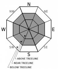
A WINTER STORM WARNING is in effect until 11 PM PDT this evening above 4,000 feet. Expect blizzard conditions above treeline through Saturday. Up to a foot of fresh snow is possible over the next 36 hours. Gale force winds near and primarily above treeline have and will continue to move snow onto leeward aspects. CONSIDERABLE avalanche danger remains above treeline for the wind slab avalanche problem. Reactive wind slabs are likely on slopes steeper than 35 degrees.


Avalanche Problem 1: Wind Slab
-
Character ?

-
Aspect/Elevation ?
-
Likelihood ?CertainVery LikelyLikelyPossible
 Unlikely
 -
Size ?HistoricVery LargeLargeSmall

Over the last 24 hours, winds on Gray Butte (8,000 feet) have averaged 20 mph with gusts to 50 mph out of the west/northwest. Continued strong winds and new snow will aid with wind slab growth. Gusty, erratic winds can produce unexpected and complex wind loading patterns. Pay attention out there.
Visible blowing snow, wind drifts, shooting cracks, wind eroded snow surfaces, and hollow sounding snow are all signs that you may be on or near a wind slab problem. Look for wind slabs in leeward terrain near and above treeline. Avoid them by sticking to protected or wind scoured areas. Steer clear of wind loaded slopes 35 degrees and steeper and avoid runout zones.
Forecast Discussion
Mother Nature is knocking at the door with Mr. Wind glaring over her shoulder. Fresh snow and wind will create for potentially touchy conditions in the backcountry, especially near and above treeline. Shred lightly and use all the tools in your box to make safe decisions while in or near avalanche terrain today.
Recent Observations
- Below treeline, previous rain on snow event created widespread rain runnels. Manzanita bushes are springing through the surface of the breakable snowpack. Recreational sliding and riding conditions are generally poor but will improve with new snow.
- Near treeline, transitional snow surfaces provided for measureable new snow. Storm totals for this last wave averaged 4-6 inches. Supportable skiing was possible.
- Above treeline, 6-10 inches of new snow was observed with drifts 1-1.5 feet. Erratic, gusty winds blew out of the west/northwest and were moving a lot of snow around yesterday. Textured snow surfaces were observed above 7,500 feet, though in general snow surfaces were smooth. Exposed areas were scoured. Gully bottoms held supportable, dry and creamy sliding surfaces.
- No recent avalanches have been observed, however visible wind loading has been occurring for the past 24 hours above treeline.
Weather and Current Conditions
Weather Summary
About an inch of water is forecast to fall over the course of the next 36 hours with snow levels near 2 to 3,000 feet. Strong southwesterly winds will dominate exposed terrain for the foreseeable future. We could see about a foot of fresh snow on the big hill by the end of tomorrow.
24 Hour Weather Station Data @ 4:00 AM
| Weather Station | Temp (°F) | Wind (mi/hr) | Snow (in) | Comments | ||||||||
|---|---|---|---|---|---|---|---|---|---|---|---|---|
| Cur | Min | Max | Avg | Avg | Max Gust | Dir | Depth | New | Water Equivalent | Settlement | ||
| Mt. Shasta City (3540 ft) | 39 | 36 | 43 | 39.5 | 1 | N | ||||||
| Sand Flat (6750 ft) | station down | |||||||||||
| Ski Bowl (7600 ft) | 15 | 14.5 | 30 | 23.5 | 77 | 0.6 | 0.07 | 0.6 | ||||
| Gray Butte (8000 ft) | 12.5 | 12 | 29.5 | 22.5 | 20 | 49 | WNW | |||||
| Castle Lake (5870 ft) | 0 | 0 | 0 | 0 | 0 | 0 | 0 | station down | ||||
| Mount Eddy (6509 ft) | 18.5 | 17.5 | 33.5 | 27 | 2 | 19 | SSE | 45 | 0 | 0 | ||
| Ash Creek Bowl (7250 ft) | station down | |||||||||||
| Ash Creek Ridge (7895 ft) | station down |
Two Day Mountain Weather Forecast
Produced in partnership with the Medford NWS
| For 7000 ft to 9000 ft | |||
|---|---|---|---|
|
Friday (4 a.m. to 10 p.m.) |
Friday Night (10 p.m. to 4 a.m.) |
Saturday (4 a.m. to 10 p.m.) |
|
| Weather | Breezy, snow showers | Snow showers, slight chance of thunderstorms | Cloudy, chance of of snow showers |
| Temperature (°F) | 29 | 18 | 26 |
| Wind (mi/hr) | S 15-20 mi/hr | SW 15-20 mi/hr | S 10-15 mi/hr |
| Precipitation SWE / Snowfall (in) | / 4-6 | / 4-6 | / 2-4 |
| For 9000 ft to 11000 ft | |||
| Friday | Friday Night | Saturday | |
| Weather | Snow showers, heavy at times, windy. | Snow showers, windy. | Snow showers, windy. |
| Temperature (°F) | 12 | 4 | 8 |
| Wind (mi/hr) | SW 40-50 mi/hr | SW 5-7 | SW 30-40 mi/hr |
| Precipitation SWE / Snowfall (in) | / 5-7 | / 5-7 | / 3-5 |
Season Precipitation for Mount Shasta City
| Period | Measured (in) | Normal (in) | Percent of Normal (%) |
|---|---|---|---|
| From Oct 1, 2023 (the wet season) | 15.48 | 34.20 | 45 |
| Month to Date (since Apr 1, 2024) | 4.59 | 4.70 | 98 |
| Year to Date (since Jan 1, 2024) | 9.65 | 18.99 | 51 |

