

You are here
Avalanche Advisory for 2018-04-03 07:01
- EXPIRED ON April 4, 2018 @ 7:01 amPublished on April 3, 2018 @ 7:01 am
- Issued by Andrew Kiefer - Mt Shasta Avalanche Center
Bottom Line
Although strong southwest winds will likely keep snow and ice firm and frozen today, continue to watch for wet loose instabilities and falling rime ice during periods of intense solar radiation. A potent storm series will bring a return to winter late in the week.


Avalanche Problem 1: Normal Caution
-
Character ?

-
Likelihood ?CertainVery LikelyLikelyPossible
 Unlikely
 -
Size ?HistoricVery LargeLargeSmall

Generally safe avalanche conditions exist in the backcountry. Both natural and human triggered avalanches are unlikely. Exercise NORMAL CAUTION and watch for isolated wet loose instabilities on steep southerly aspects.
- Strong solar radiation and warm temperatures can cause wet loose avalanches. Travel when the snow surface is colder and stronger. Avoid crossing on or under very steep sunlit slopes with wet, unconsolidated snow surfaces.
- Small cornices exist on easterly aspects above treeline. They may weaken and fall as the warm and sunny spring weather continues. Avoid traveling on top of or below these formations.
Forecast Discussion
Spring conditions exist in the backcountry for now. The upper snowpack has gone through several melt-freeze cycles in the past week. Corn skiing and riding has been found with good timing. A potent storm series will begin Thursday bringing plenty of snow and rain. Expect conditions to change quickly throughout the advisory area and for the avalanche danger to rise by the weekend.
Recent Observations
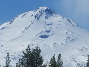
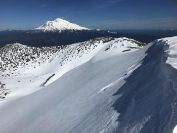
Yesterday, strong northwest winds blew with gusts up to 70 mph at the Gray Butte weather station. Winds died down late afternoon and overnight and become variable in direction. Temperatures remained cool throughout the advisory area with highs in upper 30s and mid 40s. Snow surfaces are firm and icy at upper elevations, and a corn cycle has begun on southerly aspect below 9,000 ft. Wet loose activity has been very limited by high winds the last 2 days. A ride in the Ash Creek Butte area yesterday revealed good snow coverage above 6,500 ft with consistent snow depths of 4-6 ft. Below, the Tri-Forest Snowmobile area trails are getting thin and melting out quickly. The east side climbing routes on Mount Shasta have good coverage, but access is still limited by several miles of snow covered roads. Check out the observation below for the full report.
Weather and Current Conditions
Weather Summary
A weak ridge of high pressure will bring clear and dry conditions today. Highs will be in the mid 50s at 7,000 ft with sunshine in the morning and increasing clouds in the afternoon. Strong and gusty winds will blow out of the southwest. Low pressure will move into the area late tomorrow night bringing light precipitation. Very wet and windy weather will continue Thursday through Saturday with high snow levels.
24 Hour Weather Station Data @ 4:00 AM
| Weather Station | Temp (°F) | Wind (mi/hr) | Snow (in) | Comments | ||||||||
|---|---|---|---|---|---|---|---|---|---|---|---|---|
| Cur | Min | Max | Avg | Avg | Max Gust | Dir | Depth | New | Water Equivalent | Settlement | ||
| Mt. Shasta City (3540 ft) | 25 | 25 | 53 | 41 | 5 | NE | ||||||
| Sand Flat (6750 ft) | station down | |||||||||||
| Ski Bowl (7600 ft) | 30.5 | 28 | 38.5 | 33 | 74.5 | 0 | 0 | 1 | ||||
| Gray Butte (8000 ft) | 32 | 28 | 36.5 | 32 | 10 | 70 | NW | |||||
| Castle Lake (5870 ft) | station down | |||||||||||
| Mount Eddy (6509 ft) | 26 | 24 | 36.5 | 29 | 3 | 15 | WSW | 41 | 0 | 0 | ||
| Ash Creek Bowl (7250 ft) | station down | |||||||||||
| Ash Creek Ridge (7895 ft) | station down |
Two Day Mountain Weather Forecast
Produced in partnership with the Medford NWS
| For 7000 ft to 9000 ft | |||
|---|---|---|---|
|
Tuesday (4 a.m. to 10 p.m.) |
Tuesday Night (10 p.m. to 4 a.m.) |
Wednesday (4 a.m. to 10 p.m.) |
|
| Weather | Mostly sunny | Mostly cloudy | Mostly cloudy |
| Temperature (°F) | 48 | 33 | 48 |
| Wind (mi/hr) | SSW 5-10 | SW 10-15 | S 5-10 |
| Precipitation SWE / Snowfall (in) | / 0 | / 0 | / 0 |
| For 9000 ft to 11000 ft | |||
| Tuesday | Tuesday Night | Wednesday | |
| Weather | Mostly sunny and windy | Mostly cloudy and windy | Mostly cloudy and windy |
| Temperature (°F) | 26 | 23 | 25 |
| Wind (mi/hr) | W 20-30 | NW 0 | SW 20-30 |
| Precipitation SWE / Snowfall (in) | / 0 | / 0 | / 0 |
Season Precipitation for Mount Shasta City
| Period | Measured (in) | Normal (in) | Percent of Normal (%) |
|---|---|---|---|
| From Oct 1, 2023 (the wet season) | 15.95 | 35.69 | 45 |
| Month to Date (since Apr 1, 2024) | 0.00 | 0.23 | 0 |
| Year to Date (since Jan 1, 2024) | 10.12 | 20.48 | 49 |

