

You are here
Avalanche Advisory for 2018-04-14 05:47
- EXPIRED ON April 15, 2018 @ 5:47 amPublished on April 14, 2018 @ 5:47 am
- Issued by Nick Meyers - Shasta-Trinity National Forest
Bottom Line
LOW danger exists for all aspects and elevations. Normal caution is advised. Watch for falling rime ice off exposed cliffs on the upper mountain, especially in the Helen Lake, Trinity Chutes, Redbanks areas. Smooth, firm snow surfaces provide the chance for a long slide for life on many routes currently. Climb and descend with care, know how to use your ice axe and crampons, wear a helmet. Be prepared for any type of weather in the springtime.


Avalanche Problem 1: Normal Caution
-
Character ?

-
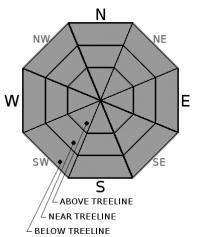
Aspect/Elevation ?
-
Likelihood ?CertainVery LikelyLikelyPossible
 Unlikely
Generally safe avalanche conditions exist in the backcountry. Both natural and human triggered avalanches are unlikely. Remember, LOW avalanche danger does not mean NO avalanche danger. In alpine areas above treeline, watch for small, isolated wind slabs where areas of drifting may have occurred. Always practice safe travel habits in the backcountry. Good questions to always ask yourself include:
- Is this a likely spot for triggering an avalanche?
- Am I exposed to possible natural avalanches or rime ice fall from above?
- Are there terrain traps below that would increase the severity of being caught in an avalanche?
- Are there options to escape or adjust my route if conditions prove different than expected?
Springtime brings the chance for any type of weather: a sunny day today can be followed by full value, winter conditions the next. Be prepared for rapidly changing conditions as late season storms roll through.
Forecast Discussion
The Mount Shasta spring climbing season is right around the corner. Conditions are good and we are expecting an early and short window of ideal climbing conditions this year. We can't stress enough: Be prepared and make sure you have the proper knowledge, skills and equipment to safely make a go of the mountain. Further, make good decisions, know the limits of your group, stick together, don't climb into a whiteout, know how to self-arrest. These are all common denominators that folks have failed to adhere to in the past, leading to accidents. Come enjoy the majesty of Mount Shasta, but remember that your safety is most important.
Recent Observations
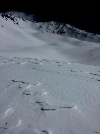
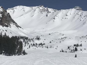
It's a mixed bag out there at the moment. A mostly clear day was had on Mount Shasta yesterday with a couple stagnant clouds that lingered here and there, obscuring visibility at times. Lower Casaval Ridge hosted a few roller balls off E/SE facing slopes in the afternoon. Wind blown powder from our recent storm got cooked pretty well and breakable crust is possible in some areas. Ridgelines, morain tops, and other windy areas are scoured down to the old, hard snow surface. Some old snow surfaces softened to corn-like conditions. Near Lake Helen and above, one will find firm, scabby windboard. Winds were strong out of the NW early in the day but mellowed out in the afternoon. Signs of instability were few to none. Rime ice is plastered to exposed cliffs on the upper mountain.
Weather and Current Conditions
Weather Summary
Today brings partly cloudy skies, near normal temperatures and an overall dry day. The next front will arrive Saturday evening. Rain chances will increase from west to east with light to moderate rain expected. Snow levels will be above 6,000 feet and will lower to 5,000 feet by late Sunday morning. Snow levels will continue to drop throughout the day and bottom out near 2,000 feet by late Sunday. Precipitation will be showery in nature. Additionally, Sunday will bring breezy winds of 40+ mi/hr on the mountain. Showers will continue into Monday. Snow rations are not super high at this poing as mid-April storms tend to have heavier, wet snow. Chance of precipitation decreases for the week in response to a building ridge of high pressure.
24 Hour Weather Station Data @ 3:00 AM
| Weather Station | Temp (°F) | Wind (mi/hr) | Snow (in) | Comments | ||||||||
|---|---|---|---|---|---|---|---|---|---|---|---|---|
| Cur | Min | Max | Avg | Avg | Max Gust | Dir | Depth | New | Water Equivalent | Settlement | ||
| Mt. Shasta City (3540 ft) | 36 | 33 | 57 | 45 | 2 | N | ||||||
| Sand Flat (6750 ft) | station down | |||||||||||
| Ski Bowl (7600 ft) | 32 | 19 | 42 | 32.5 | 77.9 | 0 | 0 | 3.6 | ||||
| Gray Butte (8000 ft) | 32 | 20 | 39.5 | 31 | 4 | 18 | WNW | |||||
| Castle Lake (5870 ft) | 0 | 0 | 0 | 0 | 0 | 0 | 0 | station down | ||||
| Mount Eddy (6509 ft) | 33 | 24 | 41 | 34 | 2 | 7 | WSW | 37.2 | 1.8 | 3.5 | ||
| Ash Creek Bowl (7250 ft) | station down | |||||||||||
| Ash Creek Ridge (7895 ft) | station down |
Two Day Mountain Weather Forecast
Produced in partnership with the Medford NWS
| For 7000 ft to 9000 ft | |||
|---|---|---|---|
|
Saturday (4 a.m. to 10 p.m.) |
Saturday Night (10 p.m. to 4 a.m.) |
Sunday (4 a.m. to 10 p.m.) |
|
| Weather | Partly cloudy | Mostly cloudy | Rain and snow, colder. Snow level near 5,500 feet. |
| Temperature (°F) | 51 | 33 | 38 |
| Wind (mi/hr) | SW 5-10 | S 10-15 | S 10-15 |
| Precipitation SWE / Snowfall (in) | / 0 | / 0 | / 4-6 |
| For 9000 ft to 11000 ft | |||
| Saturday | Saturday Night | Sunday | |
| Weather | Partly cloudy | Mostly cloudy, windy. | Snow, heavy at times, temps falling, windy. |
| Temperature (°F) | 26 | 22 | 22 |
| Wind (mi/hr) | SW 20-30 | SW 0 | SW 30-40+ |
| Precipitation SWE / Snowfall (in) | / 0 | / 0 | / 6-8 |
Season Precipitation for Mount Shasta City
| Period | Measured (in) | Normal (in) | Percent of Normal (%) |
|---|---|---|---|
| From Oct 1, 2023 (the wet season) | 17.81 | 36.87 | 48 |
| Month to Date (since Apr 1, 2024) | 1.86 | 1.41 | 132 |
| Year to Date (since Jan 1, 2024) | 11.98 | 21.66 | 55 |

