

You are here
Avalanche Advisory for 2016-03-18 06:27:13
- EXPIRED ON March 19, 2016 @ 6:27 amPublished on March 18, 2016 @ 6:27 am
- Issued by Nick Meyers - Shasta-Trinity National Forest
Bottom Line
Overall, LOW avalanche danger will be found in the forecast area today for most elevations and aspects.
As daytime warming occurs, expect pockets of MODERATE danger on E-SE-S-SW aspects, below and near treeline, due to wet-loose instabilities. While likely inconsequential today, loose-wet instabilities such as roller balls and point release style slides have the ability to entrench more snow as they move downhill and become potentially large.
Normal caution advised.


Avalanche Problem 1: Loose Wet
-
Character ?

-
Aspect/Elevation ?
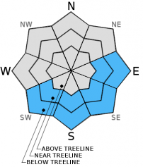
-
Likelihood ?CertainVery LikelyLikelyPossible
 Unlikely
 -
Size ?HistoricVery LargeLargeSmall

Temperatures in the last 24 hours did not drop below freezing at our weather station locations. High temps yesterday reached into the mid 50's F. Today will be warm again and loose-wet instabilities are likely. We don't expect any large slides, and most will be small, but it is possible that a loose wet slide could at least knock a rider off their feet and into a potentially bad terrain trap... a gully, off a cliff, into a crevasse, into trees. Pay attention to the slope you're on and what direction it faces. If you seen roller balls starting to form, it's a good sign that larger slides are possible. From about the noon hour until 3-4 pm is the warmest portion of the day and if on southerly slopes, use caution. Mt Shasta has the potential for very large loose wet slides due to the consistent, long fetch of certain slopes. While not a big concern today, as we move into spring and you start to think about your spring ski mountaineering and climbing adventures, larger loose wet slides will be a concern.
Cooler air will move in later today and this weekend, decreasing the danger of any loose-wet slides.
Avalanche Problem 2: Cornice
-
Character ?

-
Aspect/Elevation ?
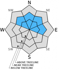
-
Likelihood ?CertainVery LikelyLikelyPossible
Unlikely
-
Size ?HistoricVery LargeLargeSmall
Small to large cornice formations has been observed on leeward facing slopes from the gale force southerly winds of weeks past. Poor overnight re-freeze and warm daytime high's will weaken cornices and provide a good chance for cornice failure. Can you say, 3-2-1 dropping? Yeah, not your line, but you dropping with that cornice you're standing on! Stay back, well back, away from cornices and on terra firma. Note trees and rocks protruding from the snow and travel in that area. Taking the elevator drop with a cornice is just the beginning - what is below? Will the cornice trigger a slide? Sweep you down a steep couloir? Over a cliff? You get it. Be careful. Aspects NW-N-NE will host the largest cornices.
Forecast Discussion
Another warm one today. We will have to see if we top yesterday's high temps... it's looking to be near the same, perhaps a degree or two cooler as the day progresses and colder air moves in. Get your last sunshine fix today - El Nino will continue to deliver with another round of systems on deck for this weekend. Set to arrive late Saturday/Sunday, these storms while not nearly as wet as the past two weekend's storms, will still give us an atmospheric river and solidify March as above normal for precipitation. El Nino is holding up to it's expectations, however models suggest it weakening and becoming neutral by summer. Regardless, March has been and will continue to be wet. Snow levels with this weekends system will start out high... imagine that... and lower as a cold air follows. Timing will be everything and as of now, it looks like much of the storm will arrive warm, followed by a cool top off. This will mean snow for the high country and more rain for most elevations. All good in our book. Water is life!
Expect increasing clouds tomorrow. Mid-mountain winds will pick up out of the southwest as the storm approaches. Climbers, this weekend doesn't look favorable for a summit attempt unless you climb today and early tomorrow. Even then, keep an eye to the sky. The upper mountain can become shrouded in clouds and it's been the cause of many disoriented and lost climber search and rescue's in the past. The climbing season is just beginning and their is plenty of time for good conditions and weather. Play it safe, we want you to come back alive!
THIS SEASON PRECIPITATION for MT SHASTA CITY: Since October 1st (the wet season), we have received 35.35 inches of water, normal is 33.38 inches, putting us at 105% of normal. For the month of March we've received 9.83 inches of water, normal is 3.88 inches, putting us at 253% of normal, and finally... for the year of 2016 we've received 25.86 inches of water, normal is 17.17 inches, putting us at 142% of normal.
Recent Observations
Yesterday temperatures soared into the lower to mid 50's at local weather stations and I can attest... it was down right warm! Roller ball action picked up a little bit on warm easterly and southerly slopes, but loose-wet instabilities that were observed were inconsequential... not a threat to human life. All loose-wet related instabilities existed below and near treeline. While the sun has been ample, above treeline temps have been staying cool enough with accomanied wind that the snow is staying put. Much of the terrain above treeline has been blasted by wind as well, creating wind packed sastrugi and scouring ridges down to old crusts and ice. In fact, late in the day a few days ago on the East side of the mountain, the light was at the perfect angle to highlight glistening icy patches in the exposed areas. Typical of Mt Shasta, while the ridges are firm, the gullies and depressions are still holding some decent snow near and above treeline. All in all however, Shasta variable is the name of the game right now. If you missed some of this week's advisories, we've noted that upwards of 4 feet of snow fell during the course of just a couple days last weekend. That is a lot of snow and it will take time to get all that new snow going into a melt/freeze cycle. Another 3-4 inches of settlement was recorded at our weather stations in the last 24 hours.
We've come across avalanche debris in various locations over the forecast area this week. All debris was evidence of considerable to high danger during the storm. It was primarily wind loaded east and northeast aspects below ridgelines with a few northwest facing slopes that slid. WIth several days of warm weather, instabilities have been far and few between and currently there are few avalanche concerns. Wet-loose related roller balls and sluffs are the primary concern, however as mentioned, will likely not present a threat to human life.
Four feet of new isothermic and well consolidated snowpack sits on top of the March 10th crust. Stability tests in snow pits have revealed consistent ECTX results all week. There is the very off chance that a hanging wind pillow on a steep slope in extreme terrain could be triggered, but we havn't seen any good signs of this yet. Wind can always form new wind slabs, even on sunny days, but new snow available for transport is minimal. The low danger will continue today however will rise this weekend as another round of rain and snow move over the forecast area.
A few have been making it onto the upper mountain this week, taking advantage of the calm winds and sunny skies. Conditions in the Trinity Chutes can be seen in pictures below and was described as pretty smooth with chalky and semi-soft, wind affected snow followed by a fun a continuous decent linking smooth section to smooth section.
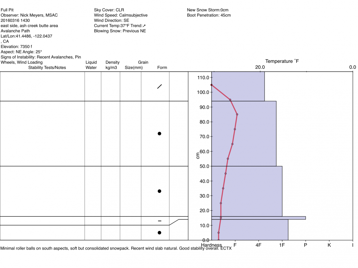
Pit profile from the east side of the forecast area. This profile reflects much of what we've been seeing over the entire forecast area... Four feet of new snow on top of the March 10th crust layer. Supportable to skis and a snowmobile, the new snow is still soft in areas, boot penetration 40-50 cm.
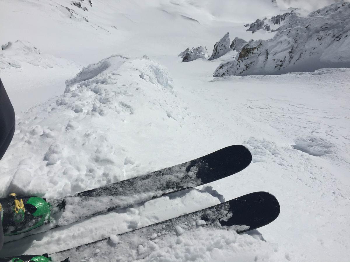
Looking down the Trinity Chutes on March 16th.- Photo: Shane Rathbun
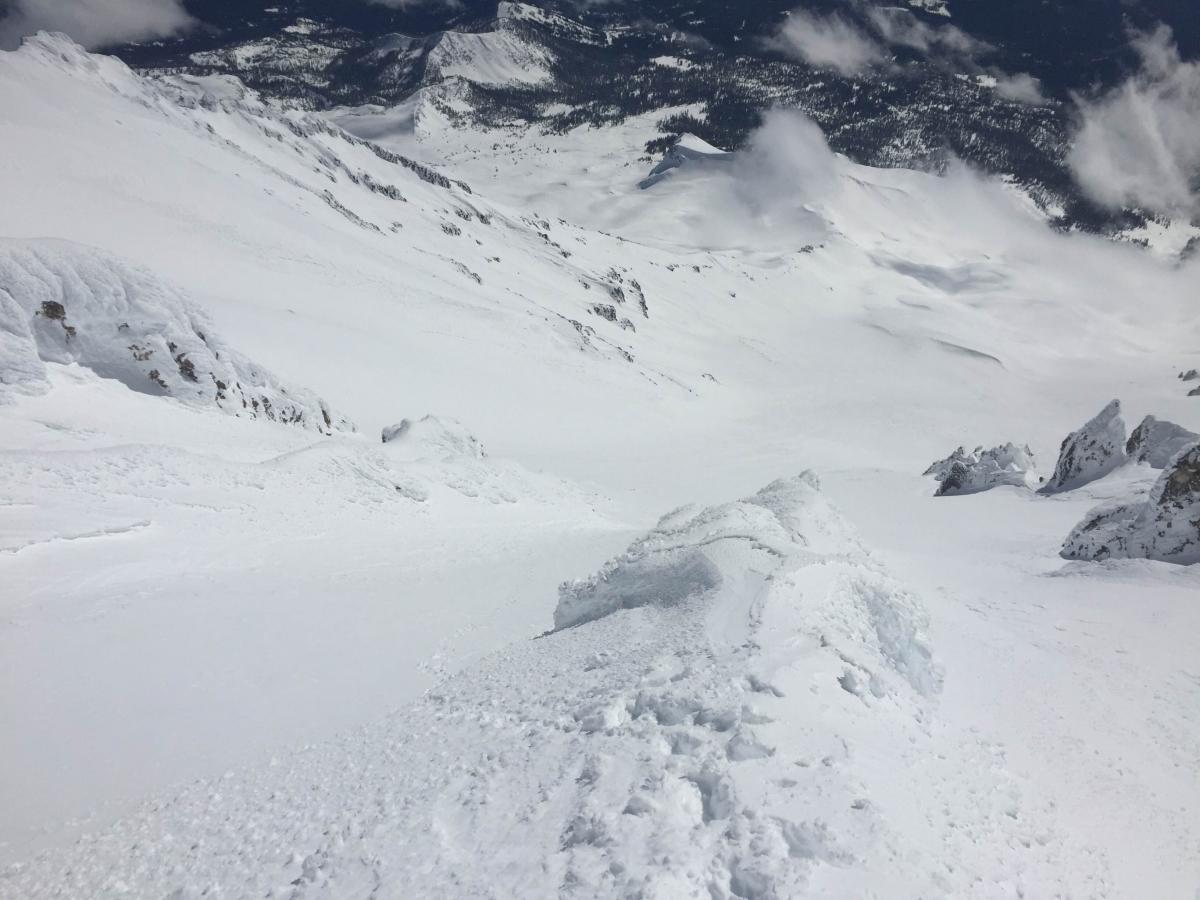
Trinity Chutes, March 16th, Avalanche Gulch below - Photo: Shane Rathbun
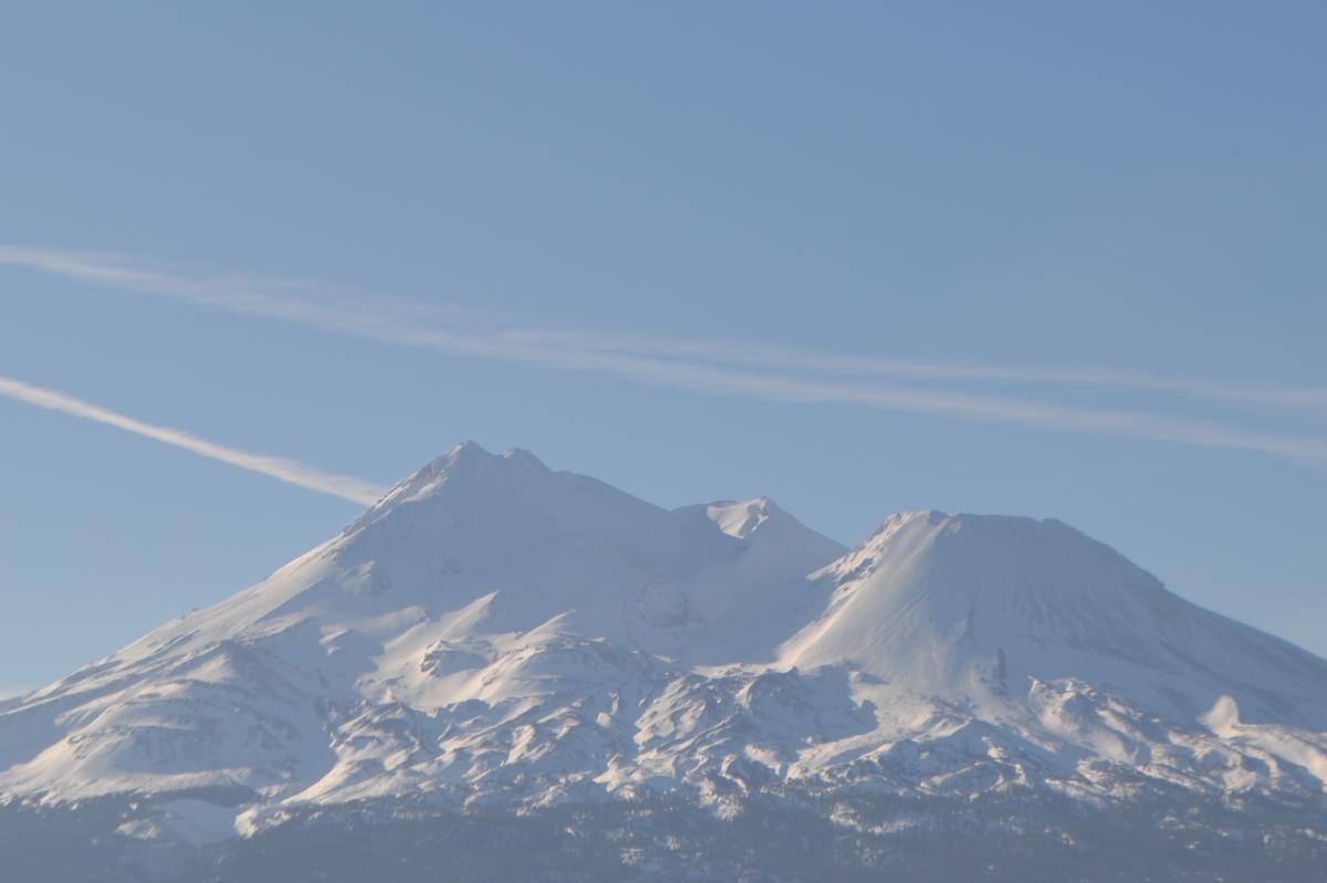
The North side of Mt Shasta, March 17th. - Photo: Zack a.k.a. Beaver Chief
-----------------------------------------------------------------------------------------------------------------------------------------------------------
LOCAL AREA ROAD, NORDIC, AND SNOWMOBILE PARK STATUS:
The Sand Flat cross country ski trails are in good shape and ready for your cross country skis and snow shoes. These are backcountry routes marked with blue diamonds on trees. Trails are not groomed. Snow shoers, please blaze a parallel trail to cross country skiers staying out of the skin track. These trails can be accessed via the Everett Memorial Highway. Thank you, and enjoy!
The Mt. Shasta Nordic Center is open! These beautiful, groomed trails can be accessed via the Ski Park Highway. http://www.mtshastanordic.org
The Pilgrim Creek & Deer Mountain Snowmobile Parks are open! Trails have not been groomed in the past week and a half due to constant deep snow fall. Head to our "Education" tab on our website and find the snowmobile section for trail information, grooming status, and other sledder resources.
The Castle Lake Road is CLOSED at the gate. The culvert blew out and we do not know when it will be repaired. The Everett Memorial Highway is plowed to Bunny Flat and currently mostly snow free until about Red Fir Flat up.
The Five Red Flags of Avalanche Danger any time of year include: 1) Recent/current avalanche activity 2) Whumphing sounds or shooting cracks 3) Recent/current heavy snowfall 4) Strong winds transporting snow 5) Rapid warming or rain on snow.
Weather and Current Conditions
Weather Summary
Good Morning! In Mt Shasta City at 0500, we have a current temperature of 33 F, one degree cooler than yesterday at this time. Skies are mostly clear with calm wind.
On Mt Shasta (South Side) in the last 24 hours...
Old Ski Bowl - 7,600 feet, the current temperature is 33 degrees F. Snow on the ground totals 164 inches with no new snow and 4 inches of settlement. Temperatures have ranged from 34 F to 51 F.
Gray Butte - 8,000 feet, the current temperature is 39 degrees F. Temperatures have ranged from 38 F to 48 F. Winds have been light and variable in direction averaging 4-6 mph with a gust to 14 mph.
Mt Eddy Range (West side of Interstate-5)...
Castle Lake - 5,600 feet, the current temperature is 46 degrees. Temperatures have ranged from 34 F to 57 F. Snow on the ground totals 81 inches with no new snow and 4 inches of settlement.
Mt Eddy - 6,500 feet, the current temperature is 35 degrees F. Temperatures have ranged from 34 F to 53 F. Snow on the ground measures 94 inches with no new snow and 4 inches of settlement. Winds have been west/southwest in nature with an average of 2-4 mph, and a maximum gust of 8 mph, WSW.
Always check the weather before you attempt to climb Mt Shasta. Further, monitor the weather as you climb. Becoming caught on the mountain in any type of weather can compromise life and limb. Be prepared.
| 0600 temperature: | 30 |
| Max. temperature in the last 24 hours: | 54 |
| Average wind direction during the last 24 hours: | Variable |
| Average wind speed during the last 24 hours: | 4-6 mi/hr |
| Maximum wind gust in the last 24 hours: | 14 (Gray Butte) mi/hr |
| New snowfall in the last 24 hours: | 0 inches |
| Total snow depth: | 109 inches |
Two Day Mountain Weather Forecast
Produced in partnership with the Medford NWS
| For 7000 ft to 9000 ft | |||
|---|---|---|---|
|
Friday (4 a.m. to 10 p.m.) |
Friday Night (10 p.m. to 4 a.m.) |
Saturday (4 a.m. to 10 p.m.) |
|
| Weather | Sunny, with a high near 52. South wind 5 to 10 mph. | Partly cloudy, with a low around 36. South wind around 10 mph. | A 20 percent chance of rain before 11am. Partly sunny, with a high near 46. South southeast wind 15 to 20 mph, with gusts as high as 30 mph. |
| Temperature (°F) | 52 | 36 | 46 |
| Wind (mi/hr) | South 5-10 mph | South 5-10 mph | South/Southeast 15-20 mph with gusts to 30 mph |
| Precipitation SWE / Snowfall (in) | / 0 | / 0 | / 0 |
| For 9000 ft to 11000 ft | |||
| Friday | Friday Night | Saturday | |
| Weather | Sunny, with a high near 31. Southwest wind 5 to 10 mph. | Mostly clear, with a low around 28. South southwest wind around 10 mph. | A 20 percent chance of snow before 11am. Partly sunny, with a high near 30. Windy, with a south southwest wind 25-30 mph, with gusts as high as 50 mph. |
| Temperature (°F) | 31 | 28 | 30 |
| Wind (mi/hr) | Southwest 5-10 mph | South/Southwest 0 | South/Southwest 25-30 mph, gusts to 50mph |
| Precipitation SWE / Snowfall (in) | / 0 | / 0 | / 0 |

