

You are here
Avalanche Advisory for 2016-03-27 06:47:26
- EXPIRED ON March 28, 2016 @ 6:47 amPublished on March 27, 2016 @ 6:47 am
- Issued by Jon Dove - Shasta-Trinity National Forest
Bottom Line
LOW avalanche danger exists for all elevations and aspects. Warm temperatures helped wind slabs continue to bond with underlying snow, and are becoming less sensitive to trigger. Some may remain above treeline at the tops of bowls, ridgelines, near rock outcroppings, and in steep chutes. They will be most sensitive on slopes 37 degrees and steeper. Cooling temperatures will prevent any loose wet instabilities. Evaluate snow and terrain carefully, and look for unstable snow on isolated terrain features.


Avalanche Problem 1: Wind Slab
-
Character ?

-
Aspect/Elevation ?
-
Likelihood ?CertainVery LikelyLikelyPossible
 Unlikely
 -
Size ?HistoricVery LargeLargeSmall

The strong northwest winds that developed wind slabs over the past couple of days shifted around early yesterday to a southerly then easterly flow. The winds then made a shift back to the northwest before noon. That being said, temperatures warmed significantly encouraging the snowpack to settle some and consolidate. Light rain and mist were present, reaching up to around 10,000 feet. These conditions have helped to encourage increased bonding of slabs with underlying snow. This will make wind slabs less sensitive to any type of trigger. Human trigger of wind slabs will be unlikely today. Areas where backcountry travelers should be most suspect of wind slabs will be above treeline at higher elevations (above 10,000 feet) on leeward NE-E-SE-S aspects. Lingering slabs will most likely be found in the usual places such as along ridge tops, around rock outcroppings, the tops of chutes and couloirs, and just below cornices. They will be most sensitive on slopes 37 degrees and steeper.
Forecast Discussion
A cold upper level trough will skirt along just to the north of our area this evening into Monday bringing a chance for some very light precipitation. Temperatures will begin to drop late this afternoon, and be several degrees cooler for tomorrow. Breezy northerly winds will begin to pick up this afternoon as the cold front approaches. Snow showers are possible by this evening, but accumulations will be light. Winds will be strong enough to transport any cold and light snow, or simply blow it away. Precipitation models only show a meager total water amount of 0.03 inches spread over 18 hours. Snow levels will start out around 4,000 feet then drop to around 3,000 feet by tonight into Monday morning. Levels will rise modestly on Monday to 3,500-4000 feet. Clouds and winds will diminish by Tuesday as a warming and drying trend develops. Expect the second half of the week to be sunny and relatively warm.
THIS SEASON PRECIPITATION for MT SHASTA CITY: Since October 1st (the wet season), we have received 36.72 inches of water, normal is 34.79 inches, putting us at 105% of normal. For the month of March we've received 11.20 inches of water, normal is 5.29 inches, putting us at 211% of normal, and finally... for the year of 2016 we've received 27.23 inches of water, normal is 19.58 inches, putting us at 139% of normal.
Recent Observations
Yesterday started off relatively clear, but the clouds didn't waist to much time encircling Mount Shasta limiting visibility above treeline. Temperatures rose over the course of the day, and some light rain/mist was observed all the way up to around 10,000 feet. The show surface conditions were hard and icy in the morning, then softened in the afternoon. Boot penetration of 10-15 cm was recorded. There were no signs of any wind slab instabilities as the warm temperatures and light precipitation helped with continued bonding with underlying snow. We are making the transition into late season conditions where warming daytime temperatures and cool overnight refreezes are more common. This will begin to produce the famous Shasta corn snow that will make for great skiing/riding conditions this spring. That being said, winter is not over yet despite what the calendar may say. There is a cold front that will push into the area later today, and into tonight bringing the threat of some light precipitation. We will only receive a dusting of new snow with this system, and the accompanying winds will blow the snow around or completely away. Avalanche danger will not likely be affected by any new snow with this storm. Continue to use normal caution as lingering wind slabs may be present at higher elevations (above 10,000 feet). They will be found in the usual locations along ridge lines, around rock outcrops, and the tops of chutes. They will be most sensitive on steeper slopes of 37 degree or more. Lower elevations will not present any noteworthy hazards. The cooling temperatures will prevent any loose wet snow instabilities for today, and tomorrow. Just because the avalanche danger is LOW, don't let your guard down. Practice safe travel techniques, and use good group communication.
Observations made at Castle Lake a couple of days ago noted melting lake edges. This is actually a serious concern... if one gets caught or knocked off their feet in any type of avalanche and the slide makes it's way down to lake level... well, lets just say it's very difficult if not impossible to dig somebody out from underneath slushy water. In other words, melting lake edges are horrible terrain traps! Be careful up there.
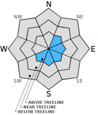
The snow's surface up in Old Ski Bowl. Note the wind's affect on the snow's surface forming sastrugi (3-26-2016):
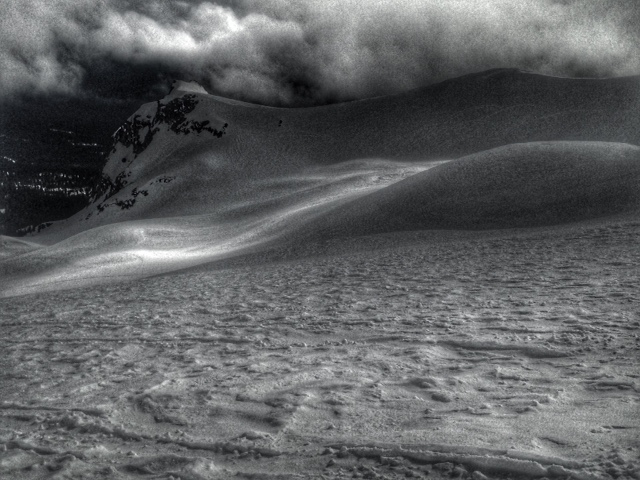
View up into Old Ski Bowl from the top of Gray Butte. Note the cornices that have formed on the top of SE facing ridge line (3-26-2016):
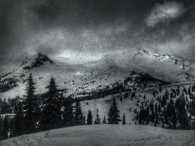
Snow banners rippling off of the ridge tops was prevalent across the forecast area (3-25-2016):
A note for all climbers and skiers heading up onto the upper mountain: Rime ice has formed on most rock outcroppings and is currently very thick. As warm days ensue, rime ice will flake off and fall down onto the slopes below. Rime ice chunks can be very large and very hard, enough to potentially kill you or cause serious injury. Beware of this hazard. Keep your eyes up slope as you climb and move laterally to avoid falling chunks of ice. If continuous ice fall is encountered turn around and descend to climb another day!
-----------------------------------------------------------------------------------------------------------------------------------------------------------
LOCAL AREA ROAD, NORDIC, AND SNOWMOBILE PARK STATUS:
The Sand Flat cross country ski trails are in good shape and ready for your cross country skis and snow shoes. These are backcountry routes marked with blue diamonds on trees. Trails are not groomed. Snow shoers, please blaze a parallel trail to cross country skiers staying out of the skin track. These trails can be accessed via the Everett Memorial Highway. Thank you, and enjoy!
The Mt. Shasta Nordic Center is open! These beautiful, groomed trails can be accessed via the Ski Park Highway. http://www.mtshastanordic.org
The Pilgrim Creek & Deer Mountain Snowmobile Parks are open! Trails have not been groomed in the past week and a half due to constant deep snow fall. Head to our "Education" tab on our website and find the snowmobile section for trail information, grooming status, and other sledder resources.
The Castle Lake Road is OPEN. The Everett Memorial Highway is OPEN. The Castle Lake and Everett Hwy are plowed year round to the trailheads. The roads are not always first priority, so your dawn patrol powder mission might be ceased if the plow has not made it up yet. Siskiyou County does a great job keeping the roads clear and be respectful of the plow drivers if you encounter them. If you get to Bunny Flat before or during when the plow is there, please park on the uphill, LEFT side of the parking lot as you drive in. This is uphill and lookers right of the bathrooms. Thank You!
The Five Red Flags of Avalanche Danger any time of year include: 1) Recent/current avalanche activity 2) Whumphing sounds or shooting cracks 3) Recent/current heavy snowfall 4) Strong winds transporting snow 5) Rapid warming or rain on snow.
Weather and Current Conditions
Weather Summary
Good Morning! In Mt Shasta City at 0500, we have a current temperature of 42 F, nine degrees warmer than yesterday at this time. Skies are clear with calm wind.
On Mt Shasta (South Side) in the last 24 hours...
Old Ski Bowl - 7,600 feet, the current temperature is 33 degrees F. Snow on the ground totals 154 inches with no new snow and 2-3 inches of settlement. Temperatures have ranged from 26 F to 43 F.
Gray Butte - 8,000 feet, the current temperature is 31 degrees F. Temperatures have ranged from 28 F to 38 F. The east/southeast winds have shifted to northwest, increasing to an average of 15-20 mph with gusts to 42 mph in the last 24 hours. Wind speeds will not be available as anemometer is being repaired. Thank you for your understanding.
Mt Eddy Range (West side of Interstate-5)...
Castle Lake - 5,600 feet, the current temperature is 34 degrees F. Temperatures have ranged from 28 F to 51 F. Snow on the ground totals 73 inches with no new snow and 1 inch of settlement.
Mt Eddy - 6,500 feet, the current temperature is 30 degrees F. Temperatures have ranged from 29 F to 46 F. Snow on the ground measures 84 inches with no new snow and 2 inches of settlement. Winds have been easterly in nature then shifting to west/southwest after 7 pm with an average of 3 mph, and a maximum gust of 9 mph, E.
Always check the weather before you attempt to climb Mt Shasta. Further, monitor the weather as you climb. Becoming caught on the mountain in any type of weather can compromise life and limb. Be prepared.
| 0600 temperature: | 34 |
| Max. temperature in the last 24 hours: | 44 |
| Average wind direction during the last 24 hours: | Southeasterly->Northwest |
| Average wind speed during the last 24 hours: | around 5 -> 15-20 mi/hr |
| Maximum wind gust in the last 24 hours: | 42 (Gray Butte) mi/hr |
| New snowfall in the last 24 hours: | 0 inches |
| Total snow depth: | 100 inches |
Two Day Mountain Weather Forecast
Produced in partnership with the Medford NWS
| For 7000 ft to 9000 ft | |||
|---|---|---|---|
|
Sunday (4 a.m. to 10 p.m.) |
Sunday Night (10 p.m. to 4 a.m.) |
Monday (4 a.m. to 10 p.m.) |
|
| Weather | Partly sunny. Increasing clouds with a 20% chance of showers. | Mostly cloudy with a 40% chance of snow showers. | Partly sunny with a 40% chance of snow showers. |
| Temperature (°F) | 39 | 18 | 31 |
| Wind (mi/hr) | Northwest shifting to the west this afternoon around 5 mph increasing to 10-15 mph this afternoon | Northwest 10-15 mph | Northwest 10-20 mph |
| Precipitation SWE / Snowfall (in) | / 0 | / 0-.5 | / 0-.5 |
| For 9000 ft to 11000 ft | |||
| Sunday | Sunday Night | Monday | |
| Weather | Partly sunny. Increasing clouds with a 20% chance of snow showers. Windy with wind chill values as low as -8 | Mostly cloudy with a 40% chance of snow showers. Windy with wind chill values as low as -22 | Partly sunny with a 50% chance of snow showers. Cold and windy. Wind chill values as low as -22 |
| Temperature (°F) | 18 | 3 | 9 |
| Wind (mi/hr) | West 30-35 mph with gusts to 45 mph | Northwest 0 | North 30-35 mph |
| Precipitation SWE / Snowfall (in) | / 0 | / 0-.5 | / 0-.5 |

