

You are here
Avalanche Advisory for 2016-12-16 06:52:54
- EXPIRED ON December 17, 2016 @ 6:52 amPublished on December 16, 2016 @ 6:52 am
- Issued by Nick Meyers - Shasta-Trinity National Forest
Bottom Line
Our recent wet and warm storm followed by cold temperatures has froze the snowpack well. Expect LOW avalanche danger below and near treeline and some remaining MODERATE danger above treeline. Lingering wind slabs are possible for human trigger. Watch for signs of wind slabs/wind pillows along ridgelines, near rock outcrops, on unsupported slopes and in narrow couloirs steeper than 37 degrees, all aspects. Further, steer clear of cornice formations along ridgelines.


Avalanche Problem 1: Wind Slab
-
Character ?

-
Aspect/Elevation ?

-
Likelihood ?CertainVery LikelyLikelyPossible
 Unlikely
 -
Size ?HistoricVery LargeLargeSmall

The wind slab problem today will be confined to primarily above treeline. A few remaining new and old wind slabs may remain above treeline for human trigger. Said slabs are likely frozen up pretty solid, however be on the lookout for smooth, rounded and sometimes hollow sounding snow, ranging from soft to hard. If observed, proceed with some caution. Slabs sit on variable surfaces, mostly smooth crusts and/or firm, icy old snow.
Avalanche Problem 2: Cornice
-
Character ?

-
Aspect/Elevation ?
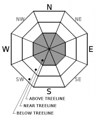
-
Likelihood ?CertainVery LikelyLikelyPossible
Unlikely
-
Size ?HistoricVery LargeLargeSmall
Pay attention to perhaps a few small to medium size cornice features out there today along ridgelines. Wet snow is great at building cornices. Give ridgelines plenty of room where cornice features may be present so you don't take the elevator drop! The ridgeline along Middle Peak at Castle Lake is famous for giant cornices. Casaval Ridge and some sections of Green Butte Ridge are also great locations for cornice features.
Forecast Discussion
High avalanche danger was short lived and confined to immediately during the recent storm. The wet and warm nature of the storm followed by a drastic drop in temperature last night has frozen our snowpack into a stable state. Evidence of naturally occuring instabilities during the storm were visible yesterday, but are unlikely today. In the alpine, a lingering unstable cornice or wind slab is possible for human trigger. Below and near treeline, backcountry travel is generally safe. Cold temperatures and northwesterly flow will bring in the weekend. Sunny skies should prevail with our next best chance of weather set for next week.
===============================================================
LOCAL AREA ROAD, NORDIC, AND SNOWMOBILE PARK STATUS:
The Sand Flat cross country ski trails are in good shape still and ready for your cross country skis and snow shoes. These are backcountry routes marked with blue diamonds on trees. Trails are not groomed. Snow shoers, please blaze a parallel trail to cross country skiers staying out of the skin track. These trails can be accessed via the Everett Memorial Highway. Thank you, and enjoy!
The Mt. Shasta Nordic Center is CLOSED for the time being but will be opening soon! The trails are covered in snow and they are working on getting things going this month. http://www.mtshastanordic.org
The Pilgrim Creek & Deer Mountain Snowmobile Parks are open, however there is no snow at these locations currently. One must drive down the 19 road (Military Pass) for several miles to get to consistent snow before unloading. Private industry is logging out there so watch out for log trucks. Head to our "Education" tab on our website and find the snowmobile section for trail information, grooming status, and other sledder resources.
The Castle Lake Road is OPEN. The Everett Memorial Highway is OPEN. The Castle Lake and Everett Hwy are plowed year round to the trailheads. The roads are not always first priority, so your dawn patrol powder mission might be ceased if the plow has not made it up yet. Siskiyou County does a great job keeping the roads clear. Be respectful of the plow drivers if you encounter them. If you get to Bunny Flat before or during when the plow is there, please park on the uphill, LEFT side of the parking lot as you drive in. This is uphill and lookers right of the bathrooms. Thank You!
The Five Red Flags of Avalanche Danger any time of year include: 1) Recent/current avalanche activity 2) Whumphing sounds or shooting cracks 3) Recent/current heavy snowfall 4) Strong winds transporting snow 5) Rapid warming or rain on snow.
Recent Observations
Observations came in from several areas on the south side of the mountain yesterday, out of the Bunny Flat trailhead. While a few noted some decent skiing early in the morning, the day gave way to some funky conditions. A light mist/rain was present at the trailhead until mid-afternoon. Rain runnels were visible on the snowpack up to about 7,500 feet. A 1-2 cm, widespread temperature crust formed on top of the new snow. Top layers of the snowpack were moist. Today, the snowpack is likely locked up from the drastic drop in temperature, 10-15 degrees cooler than yesterday at this time. The surface crust may be supportable, but due to its thin nature, we think not. Visibility was mostly poor yesterday above treeline. I was able to get a glimpse of one natural avalanche off an east facing slope near/above treeline. A wind slab with a 1-3 foot crown about 500 feet+ wide released during the storm at some point. Other ridgelines had numerous cornices failures initiating small wind slabs. A pit dug on an east aspect, very similar to the avalanche observed, revealed no obvious weak layers. The new snow is homogenous and sits on top of our old, thick melt freeze crust. Below the MF crust, lighter density snow exists, but I find it hard to imagine that fracture could initiate and propagate at this layer. See obs from yesterday below.
================================================================================
Have you seen our new, BIG BLUE buttons on our website? Yep, thats them, just up and to your left! You can use those and absolutely should. No more email, no more text, no more messing around! So cool. Please submit your observations by clicking either 'snowpack' or 'avalanche' observation and follow the template. Just a photo? Great! Snowpit profile? Awesome! Video, notes, weather...you name it, there is a place for it. It's simple, easy and fun and extremely useful for us and other users. We also have a drop down menu within the obs template that allows you to submit observations from "out of the forecast area". Heading to Crater Lake or Mt Lassen? Submit some obs! This will help us create the BEST possible avalanche advisory AND provide a great place for peeps to go for checking backcountry conditions. Saddle up!
Weather and Current Conditions
Weather Summary
Dry and cold northerly flow aloft will move into the area. A few left over showers will end today and clearing skies with a cold air mass will cause temps to plunge tonight. Daytime highs will be 10-15 degrees below normal, already being observed this moring. Northwest flow returning Saturday will stagnate things over the Pacific Northwest, holding in place into Monday morning. A dry weekend with a gradual warming trend is the jist of it. A more progressive pattern is forecasted for next week.
================================
In Mt Shasta City at 0500, we have a current temperature of 32 F, fourteen degrees cooler than yesterday at this time.
On Mt Shasta (South Side) in the last 24 hours...
Old Ski Bowl - 7,600 feet, the current temperature is 17F degrees F. Snow on the ground totals 73 inches with 4 inches new snow. Temperatures have ranged from 17F to 31F.
Grey Butte - 8,000 feet, the current temperature is 15 degrees F. Temperatures have ranged from 15 F to 31 F. Winds have averaged 15-20 mph, southwest moving to west and currently northwesterly in nature with gusts to 49 mph from the northwest.
Mt Eddy Range (West side of Interstate-5)...
Castle Lake - 5,600 feet, the current temperature is 21 degrees F. Temperatures have ranged from 21 F to 38 F. Snow on the ground totals 17 inches with 1 inch of settlement.
Mt Eddy - 6,500 feet, the current temperature is 18 degrees F. Temperatures have ranged from 18 F to 36 F. Snow on the ground measures 25 inches with no new snow. Winds have averaged 2 mph and southeasterly, with gusts to 9 mph.
THIS SEASON PRECIPITATION for MT SHASTA CITY: Since October 1st (the wet season), we have received 20.25 inches of water, normal is 10.94 inches, putting us at 185% of normal. For the month of December we received 3.78 inches of water, normal is 3.58 inches, putting us at 105% of normal, and finally... for the year of 2016 we've received 53.15 inches of water, normal is 38.94 inches, putting us at 136% of normal.
Always check the weather before you attempt to climb Mt Shasta. Further, monitor the weather as you climb. Becoming caught on the mountain in any type of weather can compromise life and limb. Be prepared.
| 0600 temperature: | 21 |
| Max. temperature in the last 24 hours: | 34 |
| Average wind direction during the last 24 hours: | SW -> W -> NW |
| Average wind speed during the last 24 hours: | 10-15 mi/hr |
| Maximum wind gust in the last 24 hours: | 30 mi/hr |
| New snowfall in the last 24 hours: | 4 inches |
| Total snow depth: | 35 inches |
Two Day Mountain Weather Forecast
Produced in partnership with the Medford NWS
| For 7000 ft to 9000 ft | |||
|---|---|---|---|
|
Friday (4 a.m. to 10 p.m.) |
Friday Night (10 p.m. to 4 a.m.) |
Saturday (4 a.m. to 10 p.m.) |
|
| Weather | Slight chance of lingering showers before 10am. Mostly sunny | Mostly clear | Sunny |
| Temperature (°F) | 22 | 8 | 26 |
| Wind (mi/hr) | North/Northwest 10-15 mph | North 10-15 mph | North/Northwest 5-10 mph |
| Precipitation SWE / Snowfall (in) | / 0 | / 0 | / 0 |
| For 9000 ft to 11000 ft | |||
| Friday | Friday Night | Saturday | |
| Weather | A chance of snow showers before 10am. Mostly sunny and cold. Windy. | Mostly clear. Windy. | Sunny. Windy. |
| Temperature (°F) | 8 | 7 | 15 |
| Wind (mi/hr) | Northwest 10-20 mph | North 0 | Northwest 30-40 |
| Precipitation SWE / Snowfall (in) | / 0 | / 0 | / 0 |

