

You are here
Avalanche Advisory for 2017-01-17 06:12:42
- EXPIRED ON January 18, 2017 @ 6:12 amPublished on January 17, 2017 @ 6:12 am
- Issued by Andrew Kiefer - Mt Shasta Avalanche Center
Bottom Line
The avalanche danger is LOW on all aspects and at all elevations. While triggering an avalanche is unlikely today, unstable snow may still exist in isolated wind-affected terrain near and above treeline. A significant winter storm is expected to begin by tomorrow. Watch for changing conditions, and expect the avalanche danger to rise with incoming new snow and strong southerly winds.


Avalanche Problem 1: Wind Slab
-
Character ?

-
Aspect/Elevation ?
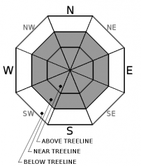
-
Likelihood ?CertainVery LikelyLikelyPossible
 Unlikely
 -
Size ?HistoricVery LargeLargeSmall

Wind slabs have the potential to exist on all aspects near treeline and above treeline. Natural and human triggered wind slab avalanches are unlikely. The wind slab problem exists in isolated areas, and has become stubborn to trigger. Unsupported terrain features, gullies, couloirs, and rocky outcrops near cliff bands are the areas where the wind slab problem is most likely to be encountered. Avoid these steep and complex terrain features that hold wind-loaded snow. Practice good travel techniques, and only expose one skier or rider at a time to avalanche terrain. Regroup in islands of safety, and be aware of what is above you and below you. Use visual observations to identify the wind slab problem.
Forecast Discussion
The snowpack continues to show signs of improving stability. Upper elevation (>10,000ft) terrain still holds the greatest potential for wind slab avalanche activity. Significant solar radiation input, and above freezing temperatures have melted snow surfaces on many slopes. In the short term, this creates the potential for isolated loose wet instabilities, but with cooling temperatures this afternoon and tonight, snowpack surfaces will refreeze and lock in place.. A series of winter storms is expected to begin by tomorrow morning. These storms look to bring heavy precipitation, strong southerly winds, and cold temperatures. If snowfall totals verify, expect conditions to change rapidly, and the avalanche danger to rise.
Recent Observations
It has been 1 week since our last storm ended, and roughly the same amount of time since any avalanche activity has occurred. Yesterday, temperatures reached 50 degrees at elevations up to 8000ft, and the majority of our remote weather stations have recorded above freezing temperatures for the past 24 hours. A temperature inversion has been in place during this time, and temperatures in Mount Shasta City and at Sand Flat did drop below freezing overnight. Variable snow surfaces exist, including wind scoured snow, melt-freeze crusts, firm and icy snow, and powder snow in shady, cold, and wind-protected areas. Very sporadic surface hoar formation has been observed near Grey Butte and in the Castle Lake area. The warm temperatures yesterday likely melted the majority of these formations, and any remaining surface hoar is not expected to cause significant concern with the incoming storms.
Weather and Current Conditions
Weather Summary
Our advisory area will experience one more day of calm before an active, wet and windy weather pattern moves in and continues through the weekend. The National Weather Service has issued a Winter Storm Warning in effect 4am Wednesday to 4am Thursday. Today, skies will become mostly cloudy by the late afternoon with moderate southerly winds and high temperatures in the mid 40’s. Freezing levels will be near 7500ft, and will drop to 4000ft by tomorrow morning. A mix of light rain and snow is expected overnight up to 6000ft. By tomorrow morning, precipitation should change to all snow, and freezing levels will continue to drop throughout the day. The advisory area may receive up to 1.5 inches of water, and 1-2 feet of new snow by the end of the day Thursday. Temperatures look to remain cold right now, and snowfall is expected to continue for the next several days.
===========================================================
In Mt Shasta City at 0500, we have a current temperature of 26 F with partly cloudy skies.
On Mt Shasta (South Side) in the last 24 hours...
Old Ski Bowl - (7,600ft) Not recording data at this time. We are working to get this station up and running again ASAP.
Grey Butte - 8,000 feet, the current temperature is 40 degrees F. Temperatures have ranged from 35 F to 50 F. Winds have averaged 10-15 mph with gusts to 42 mph, blowing out of the northwest.
Mt Eddy Range (West side of Interstate-5)...
Castle Lake - 5,600 feet, the current temperature is 41 degrees F. Temperatures have ranged from 32 F to 45 F. Snow on the ground totals 53 inches with no new snow and little settlement.
Mt Eddy - 6,500 feet, the current temperature is 38 degrees F. Temperatures have ranged from 36 F to 52 F. Snow on the ground measures 56 inches with no new snow and 2 inches of settlement. Winds have averaged 2-6 mph with gusts to 7 mph, blowing out of the west/southwest.
THIS SEASON PRECIPITATION for MT SHASTA CITY: Since October 1st (the wet season), we have received 28.27 inches of water, normal is 19.04 inches, putting us at 148% of normal. For the month of January and for the year of 2017, we received 7.11 inches of water, normal is 3.83 inches, putting us at 187% of normal.
Always check the weather before you attempt to climb Mt Shasta. Further, monitor the weather as you climb. Becoming caught on the mountain in any type of weather can compromise life and limb. Be prepared.
| 0600 temperature: | 27 |
| Max. temperature in the last 24 hours: | 34 |
| Average wind direction during the last 24 hours: | Northwest |
| Average wind speed during the last 24 hours: | 0-5 mi/hr |
| Maximum wind gust in the last 24 hours: | 10 mi/hr |
| New snowfall in the last 24 hours: | 0 inches |
| Total snow depth: | 61 inches |
Two Day Mountain Weather Forecast
Produced in partnership with the Medford NWS
| For 7000 ft to 9000 ft | |||
|---|---|---|---|
|
Tuesday (4 a.m. to 10 p.m.) |
Tuesday Night (10 p.m. to 4 a.m.) |
Wednesday (4 a.m. to 10 p.m.) |
|
| Weather | Mostly Sunny then a 30% Chance of Snow | Snow and Breezy. Chance of Precipitation 80% | Heavy Snow and Windy. Chance of Precipitation 100% |
| Temperature (°F) | 43 | 27 | 33 |
| Wind (mi/hr) | South 10-15 | South 20-30 | South 35-40 mph |
| Precipitation SWE / Snowfall (in) | / .5 | / 1-3 | / 8-12 |
| For 9000 ft to 11000 ft | |||
| Tuesday | Tuesday Night | Wednesday | |
| Weather | Mostly Sunny and Windy then 30% Chance of Snow | Snow and Windy. Chance of Precipitation 80% | Heavy Snow and Windy. Chance of Precipitation 100% |
| Temperature (°F) | 35 | 27 | 27 |
| Wind (mi/hr) | Southwest 25-30 mph | Southwest .5 | South/Southwest 50-60 mph |
| Precipitation SWE / Snowfall (in) | / .5 | / 1-3 | / 13-19 |

