

You are here
Avalanche Advisory for 2017-01-22 07:10:18
- EXPIRED ON January 23, 2017 @ 7:10 amPublished on January 22, 2017 @ 7:10 am
- Issued by Andrew Kiefer - Mt Shasta Avalanche Center
Bottom Line
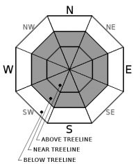
HIGH avalanche danger exists near and above treeline. CONSIDERABLE danger exists below treeline. Large and destructive wind slab and storm slab avalanches are likely to occur naturally, and very likely to be human triggered. Large cornice formations pose a significant concern as well. Travel in avalanche terrain is not recommended. The NWS Winter Storm Warning remains in effect until 4pm this afternoon.


Avalanche Problem 1: Wind Slab
-
Character ?

-
Aspect/Elevation ?
-
Likelihood ?CertainVery LikelyLikelyPossible
 Unlikely
 -
Size ?HistoricVery LargeLargeSmall

Moderate to strong winds have blown for the past 5 days and have created wind slabs on all aspects near and above treeline. Wind slabs continue to build in size, and the potential for large and destructive wind slab avalanches exists. Winds have primarily blown from the south, but significant variability has occurred in the redistribution of snow. Areas of loaded snow exist on terrain features even on windward slope aspects, especially within the several thousand feet of alpine terrain on Mount Shasta. Avoid traveling on or below steep and wind-loaded slopes today.
Avalanche Problem 2: Storm Slab
-
Character ?

-
Aspect/Elevation ?
-
Likelihood ?CertainVery LikelyLikelyPossible
Unlikely
-
Size ?HistoricVery LargeLargeSmall
Storm slabs exist on all aspects near and below treeline. Storm slabs may fail within the new snow, or at the old snow/new snow interface. Several small, human-triggered storm slab avalanches have occurred recently. Look for obvious signs of instability like recent avalanches, shooting cracks, and collapsing/whumphing. Avoid slopes steeper than 30 degrees where evidence of an unstable storm slab problem exists.
Avalanche Problem 3: Cornice
-
Character ?

-
Aspect/Elevation ?

-
Likelihood ?CertainVery LikelyLikelyPossible
Unlikely
-
Size ?HistoricVery LargeLargeSmall
Ridgelines within the advisory area hold small to large cornice features, particularly on the west side of I-5 in the Castle Lake and Cliff Lake areas. Rapid snow accumulation and wind transport are adding weight to existing cornices, and building new cornice features. Cornices are often overhung and can break in very unpredictable ways. If cornices fail, they pose a significant risk of triggering slopes below. Be sure to stand back on ridgelines, and avoid traveling on or below avalanche terrain threatened by cornice hazard.
Forecast Discussion
Five consecutive days of heavy snowfall have added more than 5 feet of new snow to the snowpack above 6000ft. The wind slab and storm slab problems have a widespread distribution throughout the terrain, and cornices continue to grow on ridgelines. Unstable conditions exist in the backcountry, and avalanche terrain should be avoided today.
This has been the largest precipitation event, and the longest period of active weather so far this season. What a storm! Precipitation forecasts for yesterday and last night verified, and we will be digging out once again this morning. Road conditions are poor, and it is very difficult to access trailheads within the advisory at this time.
Thank you very much to all who attended the 15th Anniversary Snow Ball, and participated in the Backcountry Ascension Race yesterday. We had a great turnout for both, and everyone at the Mount Shasta Avalanche Center appreciates your support.
Recent Observations
The advisory area received an additional 12-16 inches of new snow in the last 24 hours, putting the new snow total since 01/17 to over 70 inches above 6000ft. Continuous light snowfall occurred during the day yesterday before ramping up in intensity around 9pm last night. Southwest winds have shifted to the south/southeast, and have blown at speeds for productive transport of snow for the past 5 days.
Snowpack settlement has been notable this week. Overall, the recent snow we have received has accumulated in a right-side-up configuration, and bonded relatively well to the old snow surface. That being said, red flag rates for snowfall accumulation have been met every day for the past 5 days. The snowpack needs time to adjust to the several inches of water weight and feet of new snow we have received. The primary instabilities lie within the new storm snow and are very sensitive right now.
Weather and Current Conditions
Weather Summary
Gusty winds and heavy snowfall are expected, and the system bringing active weather will continue today. The National Weather Service Winter Storm Warning remains in effect until 4pm this afternoon. 12-18 inches of additional snow is expected to fall at the 6000ft level by tonight. Temperatures will reach highs in the upper 20’s and strong south winds will blow. Precipitation intensity will taper off throughout the day. Freezing levels will remain near 3000ft, and an additional 4-8 inches of snow is expected for Mount Shasta City today. We are looking to squeeze an additional inch of water out of this storm before it comes to a close on Monday night. Active weather will move out by this time, and an upper level ridge of high pressure will build into our area by Tuesday and remain in place through next weekend.
===========================================================
In Mt Shasta City at 0500, we have a current temperature of 32 F.
On Mt Shasta (South Side) in the last 24 hours...
Old Ski Bowl - (7,600ft) Not recording data at this time. We are working to get this station up and running again ASAP. Sand Flat (6,750 feet) the current temperature is 23 degrees F. Temperatures have ranged from 23 F to 29 F. Snow on the ground totals 101 inches with 11 inches of new snow and 1 inch of settlement.
Grey Butte - 8,000 feet, the current temperature is 18 degrees F. Temperatures have ranged from 17 F to 22 F. Winds have averaged 10-20 mph with gusts to 42 mph, blowing out of the west/southwest and shifting south/southeast.
Mt Eddy Range (West side of Interstate-5)...
Castle Lake - 5,600 feet, the current temperature is 23 degrees F. Temperatures have ranged from 23 F to 28 F. Snow on the ground totals 101 inches with 15 inches of new snow.
Mt Eddy - 6,500 feet, the current temperature is 21 degrees F. Temperatures have ranged from 21 F to 26 F. Snow on the ground measures 91 inches with 12 inches of new snow. Winds have averaged 2-4 mph with gusts to 20 mph, blowing southwest.
THIS SEASON PRECIPITATION for MT SHASTA CITY: Since October 1st (the wet season), we have received 31.85 inches of water, normal is 20.13 inches, putting us at 158% of normal. For the month of January and for the year of 2017, we received 10.69 inches of water, normal is 4.92 inches, putting us at 217% of normal.
Always check the weather before you attempt to climb Mt Shasta. Further, monitor the weather as you climb. Becoming caught on the mountain in any type of weather can compromise life and limb. Be prepared.
| 0600 temperature: | 23 |
| Max. temperature in the last 24 hours: | 29 |
| Average wind direction during the last 24 hours: | South/Southeast |
| Average wind speed during the last 24 hours: | 10-20 mi/hr |
| Maximum wind gust in the last 24 hours: | 42 mi/hr |
| New snowfall in the last 24 hours: | 11 inches |
| Total snow depth: | 101 inches |
Two Day Mountain Weather Forecast
Produced in partnership with the Medford NWS
| For 7000 ft to 9000 ft | |||
|---|---|---|---|
|
Sunday (4 a.m. to 10 p.m.) |
Sunday Night (10 p.m. to 4 a.m.) |
Monday (4 a.m. to 10 p.m.) |
|
| Weather | Heavy Snow and Breezy. Chance of precipitation is 100%. | Snow Showers Likely. Chance of precipitation is 70%. | Snow Showers. Chance of precipitation is 90%. |
| Temperature (°F) | 27 | 19 | 26 |
| Wind (mi/hr) | South/Southeast 20-25 mph | South 10-20 | South/Southeast 10-20 mph |
| Precipitation SWE / Snowfall (in) | / 10-14 | / 5-9 | / 3-7 |
| For 9000 ft to 11000 ft | |||
| Sunday | Sunday Night | Monday | |
| Weather | Heavy Snow and Windy. Wind chill values as low as -23. Chance of precipitation is 100%. | Heavy Snow and Windy. Wind chill values as low as -23. Windy. Chance of precipitation is 100%. | Snow Showers and Breezy. Wind chill values as low as -21. Windy. Chance of precipitation is 100%. |
| Temperature (°F) | 11 | 4 | 7 |
| Wind (mi/hr) | South 40-50 mph | Southwest 16-22 | South/Southwest 20-30 mph |
| Precipitation SWE / Snowfall (in) | / 16-22 | / 6-10 | / 3-7 |

