

You are here
Avalanche Advisory for 2017-01-25 06:58:22
- EXPIRED ON January 26, 2017 @ 6:58 amPublished on January 25, 2017 @ 6:58 am
- Issued by Nick Meyers - Shasta-Trinity National Forest
Bottom Line
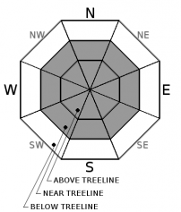
MODERATE avalanche danger exists in near and above treeline terrain steeper than 35 degrees concerning the wind slab avalanche problem. Human triggered wind slabs are still possible and while stubborn to trigger, could produce a large and dangerous avalanche. LOW avalanche danger presides below treeline. Unstable cornices also remain within the forecast area.


Avalanche Problem 1: Wind Slab
-
Character ?

-
Aspect/Elevation ?

-
Likelihood ?CertainVery LikelyLikelyPossible
 Unlikely
 -
Size ?HistoricVery LargeLargeSmall

Wind slabs are the primary avalanche problem, and may exist on all aspects near and above treeline on wind-loaded terrain 35 degrees and steeper. A human triggered wind slab avalanche is still possible today, especially above treeline. A wind slab avalanche, while becoming less of a concern and stubborn to trigger, would be large and destructive. Watch for blowing snow, cornice formation, drifts of loaded snow and textured snow surfaces to identify areas where the wind slab problem may exist.
Avalanche Problem 2: Cornice
-
Character ?

-
Aspect/Elevation ?
-
Likelihood ?CertainVery LikelyLikelyPossible
Unlikely
-
Size ?HistoricVery LargeLargeSmall
Small to large cornice features exist on ridgelines throughout the advisory area and remain easy to trigger. Cornices are often overhung and can break in very unpredictable ways. If cornices fail, they pose a risk of triggering slopes below. Identify terra firma on ridgelines as rocks, trees or shrubs poke through the snow. Otherwise, be sure to stand back on ridgelines, and avoid traveling on or below avalanche terrain threatened by cornice hazard.
Forecast Discussion
The roads to Bunny Flat (south side trailhead on Mt Shasta) and Castle Lake (west side trailhead) remain unplowed and closed at this time. Access to the backcountry can be made via the Mt Shasta Ski Park to Gray Butte or parking at McBride Springs... and of course by snowmobile to many areas. The Black Butte ski team has been out in full force as about 7 years has gone by since skiers were last able to lay tracks down the perfect 38 degree slopes. Overall, a right side up snowpack hosting overall good stability will be found within the forecast area. The wind slab problem near and mostly above treeline remains the primary avalanche problem. While we may see a lull in avalanche activity, a solid wind event could continue to load leeward slopes. Keep this in mind over the next several days. Even though it's not snowing out, wind can still load slopes 10x faster than snow falling from the sky. We've had a whopper of a storm deposit 6-8 feet of new snow over the forecast area and only one sunny day for things to settle out. Continue to keep your antenna up for potentially unstable wind slabs and cornices near and above treeline.
Recent Observations
Observations were made during a long tour on the south side of Mt Shasta yesterday, from McBride Springs (5,000 ft) up Cascade Gulch to above treeline Anaconda area (approx. 9,000 ft). We've observed upwards of 7 to 10 inches of settlement in the snowpack since the end of the storm series that began on January 17th and ended the 23rd. Below treeline, you would be hard pressed to buy an avalanche. Trees were dripping like crazy during the sunny afternoon hours and southerly aspects took a hit yesterday. A thin crust is likely today in some areas. As we begin to venture out into the backcountry after the storm, evidence of natural avalanches are being seen, but none of them have been very recent. The entire west side of Gray Butte and the entire east side of Green Butte produced large avalanches, both near/above treeline. A couple smaller slides were visible near the mouth of Hidden Valley, southerly facing above treeline. Continuing on our tour, the storm slab problem is a thing of the past. Widespread settlement and no signs of the storm slab problem were presented. Near treeline, the wind slab problem was noted in specific areas and was obvious in many areas above treeline. Wind slabs were easily avoided with visual observations. Some cornices remain and were easily triggered along ridgelines. Large cornices are possible on the west side of the forecast area. Winds were very calm yesterday and hardly a sign of any blowing snow. At one point, a whisp of snow could be seen off Shastina, but otherwise it was quite civilized. Overall, no signs of instability were observed during the day.
Weather and Current Conditions
Weather Summary
A weak front approaches from the west this morning. This front will provide nothing more than some nuisance clouds and very light precip, if any at all. A strong upper level ridge will begin to dominate our weather for the remainder of the week bringing strong inversions and mostly sunny skies. Air stagnation could be an issue for some areas as wood smoke and other pollutants become trapped in the valley bottoms. Temperatures will gradually warm over the next several days and winds will be light to moderate. Next week, model evidence indicates a wet pattern starting mid to late week. As we near the end of January, we sit at over double the normal precipitation values for the month! Yahoo!
===========================================================
In Mt Shasta City at 0500, we have a current temperature of 25 F. six degrees warmer than yesterday at this time.
On Mt Shasta (South Side) in the last 24 hours...
Old Ski Bowl - (7,600ft) Not recording data at this time. We are working to get this station up and running again ASAP. Sand Flat (6,750 feet) the current temperature is 18 degrees F. Temperatures have ranged from 5 F to 26 F. Snow on the ground totals 103 inches with no new snow and 3 inches of settlement.
Grey Butte - 8,000 feet, the current temperature is 14 degrees F. Temperatures have ranged from 10 F to 30 F. Winds have averaged 5 mph with gusts to 14 mph, variable in direction.
Mt Eddy Range (West side of Interstate-5)...
Castle Lake - 5,600 feet, the current temperature is 21 degrees F. Temperatures have ranged from 18 F to 26 F. Snow on the ground totals 103 inches with no new snow and 4 inches of settlement.
Mt Eddy - 6,500 feet, the current temperature is 19 degrees F. Temperatures have ranged from 15 F to 23 F. Snow on the ground measures 87 inches with no new snow and 4 inches of settlement. Winds have averaged 1-2 mph with gusts to 9 mph, blowing west/southwest.
THIS SEASON PRECIPITATION for MT SHASTA CITY: Since October 1st (the wet season), we have received 33.52 inches of water, normal is 20.79 inches, putting us at 161% of normal. For the month of January and for the year of 2017, we received 12.36 inches of water, normal is 5.58 inches, putting us at 221% of normal.
Always check the weather before you attempt to climb Mt Shasta. Further, monitor the weather as you climb. Becoming caught on the mountain in any type of weather can compromise life and limb. Be prepared.
| 0600 temperature: | 18 |
| Max. temperature in the last 24 hours: | 26 |
| Average wind direction during the last 24 hours: | Variable |
| Average wind speed during the last 24 hours: | 0-5 mi/hr |
| Maximum wind gust in the last 24 hours: | 10-15 mi/hr |
| New snowfall in the last 24 hours: | 0 inches |
| Total snow depth: | 103 inches |
Two Day Mountain Weather Forecast
Produced in partnership with the Medford NWS
| For 7000 ft to 9000 ft | |||
|---|---|---|---|
|
Wednesday (4 a.m. to 10 p.m.) |
Wednesday Night (10 p.m. to 4 a.m.) |
Thursday (4 a.m. to 10 p.m.) |
|
| Weather | Mostly cloudy. A 40 percent chance of snow showers after 10am. | Mostly cloudy. A 40 percent chance of snow showers. | Mostly sunny. A 30 percent chance of snow showers before 10am. |
| Temperature (°F) | 28 | 18 | 30 |
| Wind (mi/hr) | North 0-5 mph | South 0-5 mph | North 0-5 mph |
| Precipitation SWE / Snowfall (in) | / 0-.5 | / 0-.5 | / 0-.5 |
| For 9000 ft to 11000 ft | |||
| Wednesday | Wednesday Night | Thursday | |
| Weather | Mostly cloudy. A 40 percent chance of snow showers after 10am. Wind chill values as low as -16. | Mostly cloudy. A 40 percent chance of snow showers. Wind chill values as low as -13. | Mostly sunny. A 30 percent chance of snow showers before 10am. |
| Temperature (°F) | 12 | 10 | 20 |
| Wind (mi/hr) | Northwest 15-20 mph | West/Northwest 0-.5 | North 10-15 mph |
| Precipitation SWE / Snowfall (in) | / 0-.5 | / 0-.5 | / 0-.5 |

