

You are here
Avalanche Advisory for 2017-02-07 06:24:37
- EXPIRED ON February 8, 2017 @ 6:24 amPublished on February 7, 2017 @ 6:24 am
- Issued by Andrew Kiefer - Mt Shasta Avalanche Center
Bottom Line
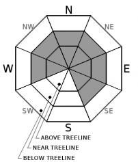
The avalanche danger is CONSIDERABLE above treeline and near treeline, while MODERATE danger exists below treeline. Previously formed wind slabs and cornices pose significant concerns to backcountry travelers. Up to a foot of new snow fell overnight above 6500ft. Continued southwest winds will add to existing wind slabs and will build fresh wind slabs. Cornices will continue to grow in size. Natural avalanches are possible, and human triggered avalanches are likely on wind loaded slopes 35 degrees and steeper.


Avalanche Problem 1: Wind Slab
-
Character ?

-
Aspect/Elevation ?
-
Likelihood ?CertainVery LikelyLikelyPossible
 Unlikely
 -
Size ?HistoricVery LargeLargeSmall

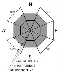
Wind slabs exist near and above treeline on W, NW, N, NE, E and SE aspects. The current wind slabs are 2-3ft thick and are building in size and distribution with continued southwest winds today. Recent deposits of wind-loaded snow are very stiff and have created hard slabs. These hard wind slabs are capable of producing large and dangerous avalanches. Watch for blowing snow, cornice formation, and newly formed wind pillows to identify areas of loaded snow. Avoid slopes 35 degrees and steeper where evidence of the wind slab problem can be found.
Avalanche Problem 2: Cornice
-
Character ?

-
Aspect/Elevation ?
-
Likelihood ?CertainVery LikelyLikelyPossible
Unlikely
-
Size ?HistoricVery LargeLargeSmall
Small to large cornice features exist on many ridgelines throughout the advisory area. The cornice formations in the Eddy Range have been especially large and impressive. Recent snow accumulation and wind transport are adding weight to existing cornices, and building new cornice features. Cornices are often overhung and can break in very unpredictable ways. If cornices fail, they pose a significant risk of triggering slopes below. Be sure to stand back on ridgelines, and avoid traveling in avalanche terrain threatened by cornice hazard from above.
Forecast Discussion
Another dose of wet, heavy snow came in overnight with rain below 5000ft. 3 or more feet of new snow have been added to the snowpack in areas 7000ft and higher during the last 5 days. Sadly, the snowpack at elevations 4000ft and below has significantly reduced in height from all of the recent rain. Strong southwesterly winds have redistributed snow throughout the terrain, building hard wind slabs and thick cornices. These avalanche problems build in size with elevation gain, but exist both near and above treeline.
Recent Observations
Areas 6500ft and higher received 6-13 inches of wet snow overnight and over 1 inch of water. The Old Ski Bowl has received 36 inches of snow in the last 5 days and close to 4 inches of water.
Overall, the new snow has bonded very well to the old snow surface. In areas protected from the wind, no significant signs of instability were found yesterday near and below treeline during a tour of Grey Butte. Evidence of wind effect and areas of loaded snow were easy to find near treeline. Cornice features guarded the majority of ridgelines in the area. Most of the cornices were small and very stiff. One small cornice failed with hard ski kicks. Wind slabs found on W, NW, and NE aspects were at least 2ft thick and very stiff - 1F to P in hand hardness. Active wind transport of snow by southwest wind was observed. The new snow is very consolidated and moist. A significant change in snow consistency was observed at the 6500ft level. Very heavy, moist snow exists near and below this elevation band. Above, the snow is noticeably drier.
Weather and Current Conditions
Weather Summary
A warm front continues to bring heavy snow and rain to the advisory area this morning. By 10am, precipitation is expected to diminish, and freezing levels will rise to 7000ft. Strong southwest winds are expected down to town level, and extreme winds will blow at the 8000ft level and higher today. Warm temperatures will last through the remainder of the week, and heavy rain is expected on Wednesday and Thursday. Freezing levels will climb to as high as 8500ft. During this time, the National Weather Service has issued a Flood Watch and High Wind Watch for Siskiyou County.
===========================================================
In Mt Shasta City at 0500, we have a current temperature of 39 F.
On Mt Shasta (South Side) in the last 24 hours...
Old Ski Bowl - 7,600ft. the current temperature is 27 degrees F. Temperatures have ranged from 19 F to 27 F. Snow on the ground measures 176 inches with 9 inches of new snow and 2 inches of settlement.
Grey Butte - 8,000 feet, the current temperature is 26 degrees F. Temperatures have ranged from 19 F to 26 F. Wind have averaged 15-25 mph with gusts to 56 mph, blowing out of the west/southwest and the west/northwest.
Mt Eddy Range (West side of Interstate-5)...
Castle Lake - 5,800 feet, the current temperature is 31 degrees F. Temperatures have ranged from 27 F to 35 F. Snow on the ground totals 101 inches with 5 inches of new snow and little settlement.
Mt Eddy - 6,500 feet, the current temperature is 30 degrees F. Temperatures have ranged from 25 F to 30 F. Snow on the ground measures 98 inches with 6 inches of new snow and little settlement. Winds have averaged 2-3 mph with gusts to 17 mph, blowing out of the south/southeast and south/southwest.
THIS SEASON PRECIPITATION for MT SHASTA CITY: Since October 1st (the wet season), we have received 34.90 inches of water, normal is 23.73 inches, putting us at 147% of normal. For the month of February, we have received 2.64 inches of water, normal is 1.46, which is 180% of normal. And finally for the year of 2017, we received 13.74 inches of water, normal is 8.52 inches, putting us at 161% of normal.
Always check the weather before you attempt to climb Mt Shasta. Further, monitor the weather as you climb. Becoming caught on the mountain in any type of weather can compromise life and limb. Be prepared.
| 0600 temperature: | 31 |
| Max. temperature in the last 24 hours: | 33 |
| Average wind direction during the last 24 hours: | SW |
| Average wind speed during the last 24 hours: | 10-15 mi/hr |
| Maximum wind gust in the last 24 hours: | 20 mi/hr |
| New snowfall in the last 24 hours: | 13 inches |
| Total snow depth: | 115 inches |
Two Day Mountain Weather Forecast
Produced in partnership with the Medford NWS
| For 7000 ft to 9000 ft | |||
|---|---|---|---|
|
Tuesday (4 a.m. to 10 p.m.) |
Tuesday Night (10 p.m. to 4 a.m.) |
Wednesday (4 a.m. to 10 p.m.) |
|
| Weather | Snow before 10am, then rain and snow showers. Windy. Chance of precipitation is 100%. | Rain and snow, mainly after 10pm. Chance of precipitation is 80%. | Rain and snow, becoming all rain after 10am. Chance of precipitation 100%. |
| Temperature (°F) | 40 | 26 | 43 |
| Wind (mi/hr) | Southwest 29-36 mph | South 23-30 mph | South 18-24 mph |
| Precipitation SWE / Snowfall (in) | / 1-3 | / 1-2 | / 0-.5 |
| For 9000 ft to 11000 ft | |||
| Tuesday | Tuesday Night | Wednesday | |
| Weather | Heavy snow and windy. Wind chill values as low as -4. Chance of precipitation is 100%. | Snow mainly after 10pm. Windy. Wind chill values as low as -4. Chance of precipitation is 80%. | Heavy snow and windy. Chance of precipitation is 100%. |
| Temperature (°F) | 26 | 21 | 28 |
| Wind (mi/hr) | West/Southwest 75-85 mph | West 6-10 | Southwest 40-50 mph |
| Precipitation SWE / Snowfall (in) | / 6-10 | / 3-5 | / 10-14 |

