

You are here
Avalanche Advisory for 2017-02-22 07:04:19
- EXPIRED ON February 23, 2017 @ 7:04 amPublished on February 22, 2017 @ 7:04 am
- Issued by Nick Meyers - Shasta-Trinity National Forest
Bottom Line
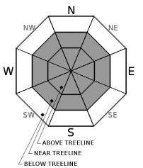
For today, expect MODERATE avalanche danger for below treeline and near treeline areas. Skier or snowmobiler triggered wind slabs, storm slabs and unstable cornice features are possible. Above treeline, winds will switch to the northwest and CONSIDERABLE danger will prevail for fresh wind slabs on southerly slopes as light density snow is available for transport.


Avalanche Problem 1: Wind Slab
-
Character ?

-
Aspect/Elevation ?
-
Likelihood ?CertainVery LikelyLikelyPossible
 Unlikely
 -
Size ?HistoricVery LargeLargeSmall

Near and above treeline, expect to find older wind slabs on northerly terrain today with some fresh wind slabs beginning to form on easterly and some southerly facing slopes as winds switch to the northwest. Wind slabs have shown improving stability however small shooting cracks in micro terrain and one recent natural avalanche in the Eddies yesterday has shown that wind slabs are still a possibility. Be cautious as you gain elevation and transition into terrain affected by the wind. Look for obvious signs of instability like recent avalanches and shooting cracks, and avoid slopes 35 degrees and steeper where evidence of the wind slab problem exists.
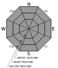
Avalanche Problem 2: Storm Slab
-
Character ?

-
Aspect/Elevation ?
-
Likelihood ?CertainVery LikelyLikelyPossible
Unlikely
-
Size ?HistoricVery LargeLargeSmall
The storm slab problem is becoming less of a concern but we are not out of the woods. Several inches of settlement has occurred in the snowpack over the past 24 hours. Be cautious for lingering storm slab instability in steep terrain with little or no wind. While settlement can strengthen the snowpack, it can also form a slab over a weak layer. We've observed heavy, dense snow resting on top of lighter, less dense snow in the advisory area and thus we cannot rule out storm slab avalanche potential.
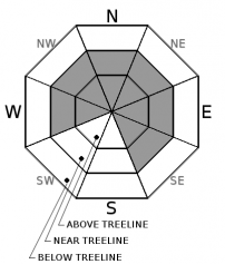
Avalanche Problem 3: Cornice
-
Character ?

-
Aspect/Elevation ?
-
Likelihood ?CertainVery LikelyLikelyPossible
Unlikely
-
Size ?HistoricVery LargeLargeSmall
Numerous, large cornices were easily triggered in the Eddy Range yesterday near and above treeline. Most cornices observed were on northerly facing slopes. Other ridgelines within the forecast area, unstable cornices are likely to be found. Stand back when cornices are observed! The weight of a fallen cornice can trigger wind and storm slabs and/or take you for a ride down a steep slope below.
Forecast Discussion
Wind slab and cornice fall avalanches all occurred naturally or were human triggered within the past few days. The avalanche hazard will remain elevated while the snowpack adjusts to the rapid load of new snow during the storm. Look for signs of instability like recent avalanches, shooting cracks, and collapses.
Recent Observations
Temperatures are about 10 degrees cooler than yesterday at this time and we've received .20 inches of SWE (snow/water equivalent) in the past 24 hours in Mt Shasta City. The Old Ski Bowl recorded only .09 SWE. Yesterday, observations were made up on the west side, in the Eddy Range. Mostly cloudy skies with periods of sun poking through and chilly temperatures was the general weather trend for the day. Short periods of graupel and very light snow occured but accumulation was minimal. Winds were light near and below treeline and moderate above treeline out of the south/southwest, transporting snow onto leeward, northerly slopes. Southerly ridgetops were scoured to bare rock. Snow surfaces were very smooth and soft with about 100-150cm (3-4 feet) of new snow measured in various locations. This the new snow from the storms that began last week. Several inches of settlement has occured in the snowpack, indicated by our weather stations and settlement cones around trees and other features. A couple cornices were observed on some leeward, north facing slopes and were easily triggered yesterday. One decent size (D2) wind slab avalanche was naturally triggered and observed on a nearby, north facing slope. This slide failed somewhere within new snow layers, had a crown of about 1-1.5 feet deep, was 150 feet wide and ran an unknown distance as the run out zone was not visible. Certainly a big enough slide to cause some trouble. While the avalanche danger seems to be improving, there were certainly some signs of unstable snow such as recent avalanches, cornice fall and wind transport of new snow. Cooler temperatures may cause weaknesses in the snowpack to linger.
Weather and Current Conditions
Weather Summary
Showers will continue this morning as temperatures and snow levels fall. Lingering showers today are expected to occur in two pulses, one this morning and another late this afternoon. Snow levels should lower to about 1,000 feet. About .21" of SWE is forecast, thus about 2 inches of new snow. The general flow of weather prevails out of the west currently but will swing to the northwest/north. This will aid in bringing cooler temperatures for the next several days. Tomorrow should be a pretty nice day with clearing skies giving way to some sun.
===========================================================
In Mt Shasta City at 0500, we have a current temperature of 30 F.
On Mt Shasta (South Side) in the last 24 hours...
Old Ski Bowl - 7,600ft, the current temperture is 15 degrees F. Temperatures have ranged from 25 F to 30 F. Snow on the ground totals 193 inches with .5-1 inch of new snow and about 3 inches of settlement
Gray Butte - 8,000 feet, the current temperature is 15 degrees F. Temperatures have ranged from 14 F to 27 F. Winds have averaged 10-15 mph with gusts to 49 mph, blowing out of the west/northwest
Mt Eddy Range (West side of Interstate-5)...
Castle Lake - 5,800 feet, the current temperature is 19 degrees F. Temperatures have ranged from 19 F to 40 F. Snow on the ground totals 111 inches with 1 inch of new snow and 4 inches of settlement.
Mt Eddy - 6,500 feet, the current temperature is 17 degrees F. Temperatures have ranged from 17 F to 29 F. Snow on the ground measures 115 inches with 1 inch of new snow and little settlement. Winds have averaged 1 mph with gusts to 10 mph, blowing southeast to southwest.
THIS SEASON PRECIPITATION for MT SHASTA CITY: Since October 1st (the wet season), we have received 43.08 inches of water, normal is 27.60 inches, putting us at 156% of normal. For the month of February, we have received 10.82 inches of water, normal is 5.33, which is 203% of normal. And finally for the year of 2017, we received 21.92 inches of water, normal is 12.39 inches, putting us at 176% of normal.
Always check the weather before you attempt to climb Mt Shasta. Further, monitor the weather as you climb. Becoming caught on the mountain in any type of weather can compromise life and limb. Be prepared.
| 0600 temperature: | 20 |
| Max. temperature in the last 24 hours: | 30 |
| Average wind direction during the last 24 hours: | W/NW |
| Average wind speed during the last 24 hours: | 10-15 mi/hr |
| Maximum wind gust in the last 24 hours: | 25 mi/hr |
| New snowfall in the last 24 hours: | .5-1 inches |
| Total snow depth: | 121 inches |
Two Day Mountain Weather Forecast
Produced in partnership with the Medford NWS
| For 7000 ft to 9000 ft | |||
|---|---|---|---|
|
Wednesday (4 a.m. to 10 p.m.) |
Wednesday Night (10 p.m. to 4 a.m.) |
Thursday (4 a.m. to 10 p.m.) |
|
| Weather | Snow showers. Chance of precipitation is 80%. | Snow showers, tapering off. Wind chill values as low as -6. Chance of precipitation is 80%. | A 20 percent chance of snow showers before 10am. Mostly sunny. Wind chill values as low as -1. |
| Temperature (°F) | 30 | 14 | 27 |
| Wind (mi/hr) | West 5-10 mph | Northwest 5-10 mph | Northwest 5-10 mph |
| Precipitation SWE / Snowfall (in) | / 2-4 | / 1-2 | / 0 |
| For 9000 ft to 11000 ft | |||
| Wednesday | Wednesday Night | Thursday | |
| Weather | Snow showers. Temperature falling. Wind chill values as low as -23. Blustery. Chance of precipitation is 80%. | Snow showers, mainly before 10pm. Wind chill values as low as -23. Chance of precipitation is 80%. | A 20 percent chance of snow showers before 10am. Partly sunny and cold. Wind chill values as low as -27. Blustery. |
| Temperature (°F) | 6 | 2 | 3 |
| Wind (mi/hr) | West 20-25 mph | Northwest 3-5 | North 15-20 mph |
| Precipitation SWE / Snowfall (in) | / 3-5 | / 1-2 | / |

