

You are here
Avalanche Advisory for 2018-02-23 06:43
- EXPIRED ON February 24, 2018 @ 6:43 amPublished on February 23, 2018 @ 6:43 am
- Issued by Nick Meyers - Shasta-Trinity National Forest
Bottom Line
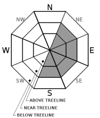
Wind slabs are the main avalanche problem of concern today. MODERATE avalanche danger will exist for most aspects and elevations of the forecast area. CONSIDERABLE avalanche danger may develop near treeline and above treeline on primarily east and southeast facing slopes due to new snow and wind.
Firm, icy ridgelines and shallow snowpack hazards still exist.


Avalanche Problem 1: Wind Slab
-
Character ?

-
Aspect/Elevation ?
-
Likelihood ?CertainVery LikelyLikelyPossible
 Unlikely
 -
Size ?HistoricVery LargeLargeSmall

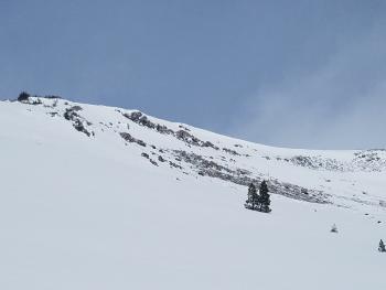
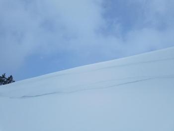
Wind slabs have developed on wind loaded slopes near and above treeline. Northwest winds will drift new, low density snow onto primarily E-SE aspects and some NE and S aspects. Additional wind slab development is expected today with continued winds blowing out of the N/NW. Avalanche size up to D2 (large enough to bury or injure a person) is possible today. Use visual clues such as blowing snow, plumes, snow drifts, and fresh cornices to identify and avoid slopes where wind is depositing snow. Slopes near or adjacent to a recent avalanche or those that have cornice features and/or wind pillows across the upper portion of the slope are the most suspect. Areas of snow surface cracking are an additional indication of unstable snow.
- Ski and ride one at a time in avalanche terrain.
- Don't regroup in run out zones.
- Avalanche rescue skills are essential in avalanche terrain.
Forecast Discussion
Backcountry users will observe winds transporting new, low density snow on Mount Shasta today. Active wind loading will continue to take place....Reactive wind slabs are possible and fresh cornices will be touchy. Pay attention out there.
Recent Observations
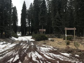
Yesterday was characterized by cold temperatures, poor visibility and windy conditions on the mountain. The small storm brought .12 inches of snow/water equivalent between 0500 and 1500 hours. This translated into 3-4 inches (at 7,900 feet) of new, low density snow on top of our shallow, rock hard snowpack. Over the past 24 hours, average wind speeds clocked in at 15 mi/hr out of the NW. Average temperature was 9.5 deg F. Natural cornice collapses were observed on leeward (E/SE/S) ridgelines in Sun Bowl. Ridgelines proper were scoured. While no natural avalanches were observed (poor visibility), blowing snow was widespread. Knee to thigh deep drifts were noted in leeward gully bottoms and depressions near treeline. Below treeline, continue to expect hidden and exposed rocks, chaparral, and forest debris.
Weather and Current Conditions
Weather Summary
Winter will continue to make up for its absence by doting upon us with cold temperatures and low level snow through most of next week. A sunny break today will be followed by a couple inches of snow tomorrow and a few more late Sunday. North/Northwest winds are going to crank for most of the weekend, especially above treeline and on the upper mountain. If you're planning a climb of Mount Shasta anytime soon, be prepared for extreme wind chill factors, blowing snow, poor visibility and full value, winter conditions.
24 Hour Weather Station Data @ 4:00 AM
| Weather Station | Temp (°F) | Wind (mi/hr) | Snow (in) | Comments | ||||||||
|---|---|---|---|---|---|---|---|---|---|---|---|---|
| Cur | Min | Max | Avg | Avg | Max Gust | Dir | Depth | New | Water Equivalent | Settlement | ||
| Mt. Shasta City (3540 ft) | 28 | 19 | 42 | 32 | 3 | |||||||
| Sand Flat (6750 ft) | station down | |||||||||||
| Ski Bowl (7600 ft) | 1.5 | 1.5 | 15 | 10 | 43.5 | 4 | 0.12 | .5 | ||||
| Gray Butte (8000 ft) | 4 | 4 | 13.5 | 9.5 | 14 | 43 | NW | |||||
| Castle Lake (5870 ft) | 11 | 11 | 24 | 17 | 10 | 2.5 | 1 | |||||
| Mount Eddy (6509 ft) | 7.5 | 7.5 | 18.5 | 13.5 | 3 | 14 | SE | 24.5 | 3.5 | 1 | ||
| Ash Creek Bowl (7250 ft) | station down | |||||||||||
| Ash Creek Ridge (7895 ft) | station down |
Two Day Mountain Weather Forecast
Produced in partnership with the Medford NWS
| For 7000 ft to 9000 ft | |||
|---|---|---|---|
|
Friday (4 a.m. to 10 p.m.) |
Friday Night (10 p.m. to 4 a.m.) |
Saturday (4 a.m. to 10 p.m.) |
|
| Weather | Sunny | Chance of snow, mainly after 4am. Mostly cloudy. | Snow showers likely, windy. |
| Temperature (°F) | 28 | 19 | 28 |
| Wind (mi/hr) | N 5-10 mi/hr | NW 5-10 mi/hr | W 10-15 mi/hr |
| Precipitation SWE / Snowfall (in) | / 0 | / 0-.5 | / 1-3 |
| For 9000 ft to 11000 ft | |||
| Friday | Friday Night | Saturday | |
| Weather | Sunny and windy | Chance of snow, mainly after 4am. Mostly cloudy. | Snow showers likely, windy. |
| Temperature (°F) | 14 | 10 | 14 |
| Wind (mi/hr) | N 30-40 mi/hr | NW 0 | W 20-30 mi/hr |
| Precipitation SWE / Snowfall (in) | / 0 | / 0-1 | / 2-4 |
Season Precipitation for Mount Shasta City
| Period | Measured (in) | Normal (in) | Percent of Normal (%) |
|---|---|---|---|
| From Oct 1, 2023 (the wet season) | 10.27 | 27.87 | 37 |
| Month to Date (since Apr 1, 2024) | 0.16 | 5.60 | 3 |
| Year to Date (since Jan 1, 2024) | 4.44 | 12.66 | 35 |

