

You are here
Avalanche Advisory for 2018-03-02 06:23
- EXPIRED ON March 3, 2018 @ 6:23 amPublished on March 2, 2018 @ 6:23 am
- Issued by Nick Meyers - Shasta-Trinity National Forest
Bottom Line
A WINTER STORM WARNING issued by the NWS Medford continues and is in effect until 4 AM PST Saturday. Wind slabs, storms slabs and/or cornice fall avalanche problems are likely. Travel in or below avalanche terrain is not recommended. If you are able to make it into the backcountry today, travel on slopes less than 30 degrees without expsoure to steeper terrain above. Poor visibility could make navigation difficult.


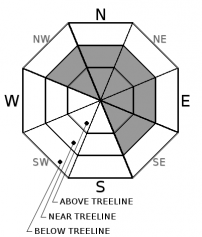
Avalanche Problem 1: Wind Slab
-
Character ?

-
Aspect/Elevation ?
-
Likelihood ?CertainVery LikelyLikelyPossible
 Unlikely
 -
Size ?HistoricVery LargeLargeSmall

Wind Slabs are most reactive during a wind/storm event and the first day or two after it has ended.in features. Look for convex pillows of wind-drifted snow on the NW-N-NE-E-SE aspects of ridges and other terrain features. The wind slab may have a chalky look and feel. Wind slabs can be very hard, and may present a hollow drum like sound as you traverse across slope. Avoid by sticking to sheltered or wind-scoured areas.
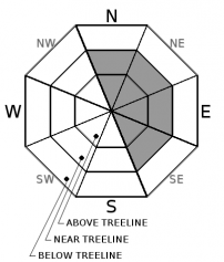
Avalanche Problem 2: Cornice
-
Character ?

-
Aspect/Elevation ?
-
Likelihood ?CertainVery LikelyLikelyPossible
Unlikely
-
Size ?HistoricVery LargeLargeSmall
Cornices develop whenever snow is available for transport and the wind is sufficiently strong to move the snow. Cornices form on the downwind (leeward) side of sharp terrain features. Ridges above treeline are the most common locations. Weather and terrain awareness are the best tools for recognizing potential cornice problems. Cornices can never be trusted; avoiding them is necessary for safe backcountry travel. While moving along ridge lines, stay well back from areas with cornice formation.
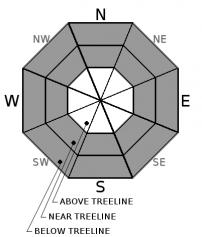
Avalanche Problem 3: Storm Slab
-
Character ?

-
Aspect/Elevation ?
-
Likelihood ?CertainVery LikelyLikelyPossible
Unlikely
-
Size ?HistoricVery LargeLargeSmall
Storm Slabs form in sheltered areas where new snow falls with light winds. They can occur on any steep open slope, and are often found on several aspects at the same time. They are easiest to trigger during periods of heavy snow and typically stabilize within a day or two after the storm cycle has ended. Natural activity on indicator slopes are often the best clues that a Storm Slab problem exists. Reduce your risk from storm slabs by waiting a day or two after a storm before venturing into steep avalanche terrain.
Forecast Discussion
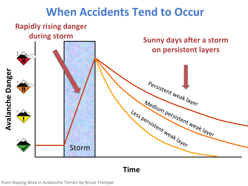
This graph illustrates our situation well with the spike in avalanche danger in relation to a storm. We are still in the midst of a strong winter storm that is bringing rapid snow accumulation and high winds. Until the snow settles out, the avalanche danger will remain elevated.
Recent Observations
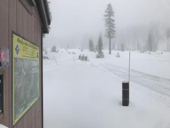
- The Everitt Memorial Highway and Castle Lake roads are closed as of yesterday afternoon.
- Snowmobile allowed access up the 31 road to the powerline road, and up to Bunny Flat and the Old Ski Bowl
- Snow measured at 1300-1400 hours: Bear Springs, 5,500 feet - 14" on bare ground / Bunny Flat, 6,950 feet - 17 inches / Old Ski Bowl, 8,000 feet - 21 inches.
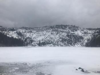
- Visibility was very poor with periods of light to moderate snow. Strong, gusty winds observed near and above treeline.
- Warming period during the day made for moist surface snow below 6,500 feet. Above, snow was dryer. Temperature at Bunny Flat was 25 deg F at 1345 hrs.
- Most new snow below 6,500 feet sits on bare ground.
- Unable to observe above treeline terrain due to whiteout conditions. One report from local sledders observed "giant wind formations".
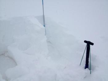
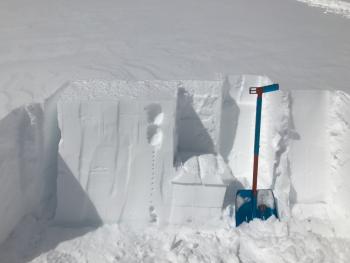
- Stability tests at a 8,100 foot, low angle test pit location revealed nothing notable. New snow is right side up. Observed two density changes at 30cm and 45cm down from surface. Any layers of concern for storm or wind slab avalanches will lie within new snow or at old snow/new snow interface.
- From the Mt Shasta Ski Park: 18-24 inches of loaded snow on top of an ice bed layer crusted with dirt on the east side of Coyote. The cornice is developing and more wind exposed areas are forming a firm slab. Winds variable, 15-45 mi/hr, SW. Temp: 25 def F at 1045 hrs.
Weather and Current Conditions
Weather Summary
A WINTER STORM WARNING remains in effect from 10AM this morning to 4AM PST Saturday. An upper low will bring continued cold and showery winter weather into Saturday. Gusty winds will sustain on Mount Shasta, near and above treeline. For the weekend, showers may linger into Saturday and diminish Sunday. Conditions begin to dry out for early next week. The next system is poised to arrive on the west coast around Wednesday or Thursday, bringing moderate precipitation.
24 Hour Weather Station Data @ 4:00 AM
| Weather Station | Temp (°F) | Wind (mi/hr) | Snow (in) | Comments | ||||||||
|---|---|---|---|---|---|---|---|---|---|---|---|---|
| Cur | Min | Max | Avg | Avg | Max Gust | Dir | Depth | New | Water Equivalent | Settlement | ||
| Mt. Shasta City (3540 ft) | 32 | 28 | 36 | 31.5 | 4 | ESE | ||||||
| Sand Flat (6750 ft) | station down | |||||||||||
| Ski Bowl (7600 ft) | 4.5 | 4.5 | 21 | 16 | 60.4 | 7 | 0.52 | 1 | ||||
| Gray Butte (8000 ft) | 5.5 | 5.5 | 20 | 15.5 | 22 | 49 | WSW | |||||
| Castle Lake (5870 ft) | 12.5 | 12.5 | 29.5 | 22.5 | 29.5 | 9 | 1 | |||||
| Mount Eddy (6509 ft) | 11 | 10.5 | 25.5 | 19.5 | 2 | 19 | SSW | 39 | 3 | 2 | ||
| Ash Creek Bowl (7250 ft) | station down | |||||||||||
| Ash Creek Ridge (7895 ft) | station down |
Two Day Mountain Weather Forecast
Produced in partnership with the Medford NWS
| For 7000 ft to 9000 ft | |||
|---|---|---|---|
|
Friday (4 a.m. to 10 p.m.) |
Friday Night (10 p.m. to 4 a.m.) |
Saturday (4 a.m. to 10 p.m.) |
|
| Weather | Breezy. Mostly cloudy. Snow showers likely this morning, then snow showers this afternoon. Chance of snow 80 percent. | Snow showers. Chance of snow 90 percent. | Chance of snow showers in the morning, then snow showers likely in the afternoon. Chance of snow 60 percent. |
| Temperature (°F) | 22 | 17 | 25 |
| Wind (mi/hr) | S 15-20 mi/hr | S 10-15 mi/hr | S 5-10 mi/hr |
| Precipitation SWE / Snowfall (in) | / 3-7 | / 3-7 | / 2-3 |
| For 9000 ft to 11000 ft | |||
| Friday | Friday Night | Saturday | |
| Weather | Snow showers. Windy. Chance of precipitation is 80%. | Snow showers. Windy Chance of precipitation is 90%. | Snow showers likely. Mostly cloudy and cold. Chance of precipitation is 60%. |
| Temperature (°F) | 6 | 5 | 6 |
| Wind (mi/hr) | SW 30-40 mi/hr | SW 4-8 | W 10-20 mi/hr |
| Precipitation SWE / Snowfall (in) | / 4-8 | / 4-8 | / 2-4 |
Season Precipitation for Mount Shasta City
| Period | Measured (in) | Normal (in) | Percent of Normal (%) |
|---|---|---|---|
| From Oct 1, 2023 (the wet season) | 11.97 | 29.76 | 40 |
| Month to Date (since Apr 1, 2024) | 1.08 | 0.26 | 415 |
| Year to Date (since Jan 1, 2024) | 6.14 | 14.55 | 42 |

