

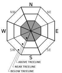
You are here
Avalanche Advisory for 2018-03-16 06:34
- EXPIRED ON March 17, 2018 @ 6:34 amPublished on March 16, 2018 @ 6:34 am
- Issued by Nick Meyers - Shasta-Trinity National Forest
Bottom Line
A WINTER STORM WARNING remains in effect through 8 AM PDT today. Snow stability below and near treeline has been good with no obvious signs of avalanche danger. Above treeline, MODERATE danger exists for wind slabs that may have formed during the recent storm. This remains our primary concern, however uncertainty exists due to whiteout conditions. If visibility allows and you find yourself above treeline today, keep your antennas up.


Avalanche Problem 1: Wind Slab
-
Character ?

-
Aspect/Elevation ?
-
Likelihood ?CertainVery LikelyLikelyPossible
 Unlikely
 -
Size ?HistoricVery LargeLargeSmall

We are on the tail end of a storm that brought several feet of new snow to Mount Shasta, accompanied by moderate south to west winds. It's a reasonable suspicion to believe that unstable wind slabs are lingering and a human trigger is still possible in alpine terrain. Use caution on leeward and cross-loaded slopes steeper than 35 degrees. Wind slabs can be recognized by the appearance of the snow surface, changes in surface snow hardness, hollow, drum-like sounds and/or shooting cracks. Winds that vary in strength and direction can produce complex and unexpected wind slab patterns. Avoid areas where wind slabs have formed.
Forecast Discussion
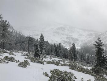
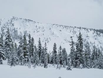
Overall, the new storm snow is showing good stability and right side up characteristics in below and near treeline terrain on Mount Shasta. The X-factor remains for above treeline where whiteout conditions have prevented good observations. If and when it does clear, tip-toe through the terrain carefully. Expect minor roller ball/point release instabilities if we do see the sunshine today.
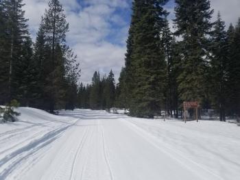
Castle Lake area does not have a usable snowpack currently. The Eddy Mountains have a barely usable snowpack. The Sand Flat winter xc-ski trails are in great shape!
Recent Observations
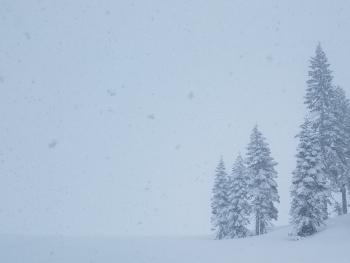
Nearly constant snowfall fell upon Southern Siskiyou County yesterday with the heaviest precipitation between 11am and 2pm. Precipitation began to fade after 3pm. In the last 24 hours, snowfall measured at 7,900 feet hovers around 6 to 8 inches. Storm totals are around the 1.5 to 2 feet mark near and above treeline on Mount Shasta. Average wind speeds recorded at the Gray Butte weather station have been light to moderate out of the SW/W. Evidence of wind loading has been minimal from what we've seen. Above treeline, visibility was limited due to whiteout conditions and observations are lacking in alpine terrain. Southerly aspects below treeline held 4-6 inches of low density new snow on top of a buried, supportable crust. Virtually zero signs of avalanche danger have been observed below and near treeline.
Late in the afternoon on Wednesday, numerous natural point release avalanches (D1) and one slab avalanche (D1) were observed during a brief break in the storm. These occurred in Powder Bowl and off Sargents Ridge into Avalanche Gulch, all southerly facing slopes above treeline.
Weather and Current Conditions
Weather Summary
A WINTER STORM WARNING remains in effect for the higher terrain of Siskiyou County through 8 AM PDT. A cold, upper level low is centered offshore this morning and will slowly move east to southeast today. Bands of showers will produce precipitation amounts that vary widely due to the spotty nature of the system. Snow levels are around 1,500 to 2,000 feet this morning and could rise to 3,000 feet by this afternoon. Precipitation amounts are minimal (.10" H20) though localized orographics could squeeze out a bit more. Shower activity will gradually diminish in coverage and intensity today. Lingering showers are possible for Saturday. The next best chance at significant winter weather is set for later next week.
24 Hour Weather Station Data @ 4:00 AM
| Weather Station | Temp (°F) | Wind (mi/hr) | Snow (in) | Comments | ||||||||
|---|---|---|---|---|---|---|---|---|---|---|---|---|
| Cur | Min | Max | Avg | Avg | Max Gust | Dir | Depth | New | Water Equivalent | Settlement | ||
| Mt. Shasta City (3540 ft) | 31 | 29 | 35 | 31.5 | 2 | N | ||||||
| Sand Flat (6750 ft) | station down | |||||||||||
| Ski Bowl (7600 ft) | 14.5 | 14.5 | 20 | 17 | 77.3 | 7.5 | 0.5 | 2.8 | ||||
| Gray Butte (8000 ft) | 14 | 13.5 | 19 | 16 | 10 | 25 | WNW | |||||
| Castle Lake (5870 ft) | 22 | 20.5 | 31.5 | 25 | 22.4 | 1.3 | 1.5 | station down | ||||
| Mount Eddy (6509 ft) | 17 | 15.5 | 25 | 20.5 | 1 | 9 | S | 43.1 | 2.3 | 1 | ||
| Ash Creek Bowl (7250 ft) | station down | |||||||||||
| Ash Creek Ridge (7895 ft) | station down |
Two Day Mountain Weather Forecast
Produced in partnership with the Medford NWS
| For 7000 ft to 9000 ft | |||
|---|---|---|---|
|
Friday (4 a.m. to 10 p.m.) |
Friday Night (10 p.m. to 4 a.m.) |
Saturday (4 a.m. to 10 p.m.) |
|
| Weather | Snow showers, chance of precipitation 100%. | Cloudy, snow showers possible, chance of precipitation 80%. | Mostly cloudy, chance of precipitation 30% |
| Temperature (°F) | 21 | 17 | 27 |
| Wind (mi/hr) | S 0-5 mi/hr | SW 0-5 mi/hr | W 0-5 mi/hr |
| Precipitation SWE / Snowfall (in) | / 3-5 | / 1-3 | / 0-1 |
| For 9000 ft to 11000 ft | |||
| Friday | Friday Night | Saturday | |
| Weather | Snow showers, breezy. Wind chill as low as -16 F. Chance of precipitation 100%. | Snow showers, mainly before 11pm. Wind chill as low as -13 F. Chance of precipitation 100%. | Mostly cloudy, cold, blustery. A 40% chance of precipitation. Wind chill as low as -16 F. |
| Temperature (°F) | 9 | 8 | 11 |
| Wind (mi/hr) | SW 10-15 mi/hr | NW 4-6 | NW 10-15 mi/hr |
| Precipitation SWE / Snowfall (in) | / 4-6 | / 2-4 | / 1-2 |
Season Precipitation for Mount Shasta City
| Period | Measured (in) | Normal (in) | Percent of Normal (%) |
|---|---|---|---|
| From Oct 1, 2023 (the wet season) | 14.31 | 33.00 | 43 |
| Month to Date (since Apr 1, 2024) | 3.42 | 3.50 | 98 |
| Year to Date (since Jan 1, 2024) | 8.48 | 17.79 | 48 |

