

You are here
Avalanche Forecast for 2019-03-29 06:04
- EXPIRED ON March 30, 2019 @ 6:04 amPublished on March 29, 2019 @ 6:04 am
- Issued by Nick Meyers - Shasta-Trinity National Forest
Bottom Line
The wind slab avalanche problem remains today. While the snowpack typically settles out quickly this time of year, continue to play it safe near and above treeline along ridgelines, steep convexities, couloirs, and/or other extreme terrain impacted by recent wind and new snow. The avalanche danger is LOW below treeline and MODERATE near and above treeline.


Avalanche Problem 1: Wind Slab
-
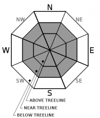
Character ?

-
Aspect/Elevation ?
-
Likelihood ?CertainVery LikelyLikelyPossible
 Unlikely
 -
Size ?HistoricVery LargeLargeSmall

Active wind loading has been observed recently. Fresh snow remains available for transport. Remain attentive to wind loaded slopes for one more day. Winds have been blowing from the S-SW-W-NW.
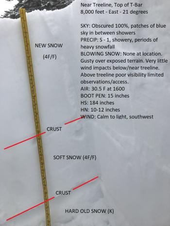
Look for convex pillows of wind-drifted snow on the lee side of ridges and other terrain features. The wind slab may have a chalky look and feel. Wind slabs can be very hard, and may present a hollow drum like sound as you traverse across slope. Snowpack tests conducted in wind-loaded areas may reveal a wind slab problem in the upper few feet of the snowpack.
Forecast Discussion
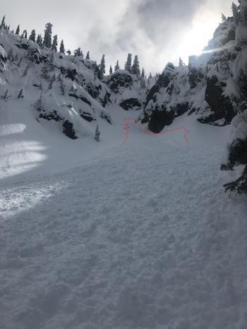
Loose-wet instabilities are knocking on the door. Recent, fresh storm snow will soon be followed by warm, spring sun. There are many clues that loose wet avalanches are likely. On small, steep test slopes, the surface layers will slide easily. Fresh roller balls–little snowballs–falling off trees and cliff bands indicate that the snowpack surface is getting weak.
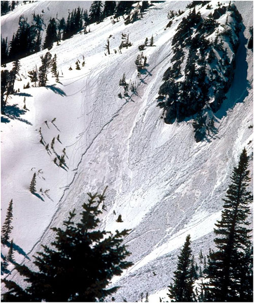
Example of loose-wet avalanches and a lot of pinwheels and roller balls.
Any climbers this weekend? Carry a beacon, shovel and probe...and know how to use them. Post-holing (i.e. sinking up to your calf, knee or thigh in soft snow) can also be a real problem. High wind can create dangerous wind chill and whiteout conditions on the mountain. Every year, climbers become lost, injured and/or die on Mount Shasta. The bottom line: BE PREPARED, check the weathe and avalanche forecast. Make sound decisions based on your knowledge, skill and ability.
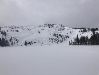
Recent Observations
Yesterday's observation tour was in the Deadfall drainage, Eddy mountains, collecting monthly snow survey information for the state of California. Despite rather mild weather in the lowlands, it was full value in the mountains. Poor visibility, deep snow, wind and steady precipitation made for an intrepid day.
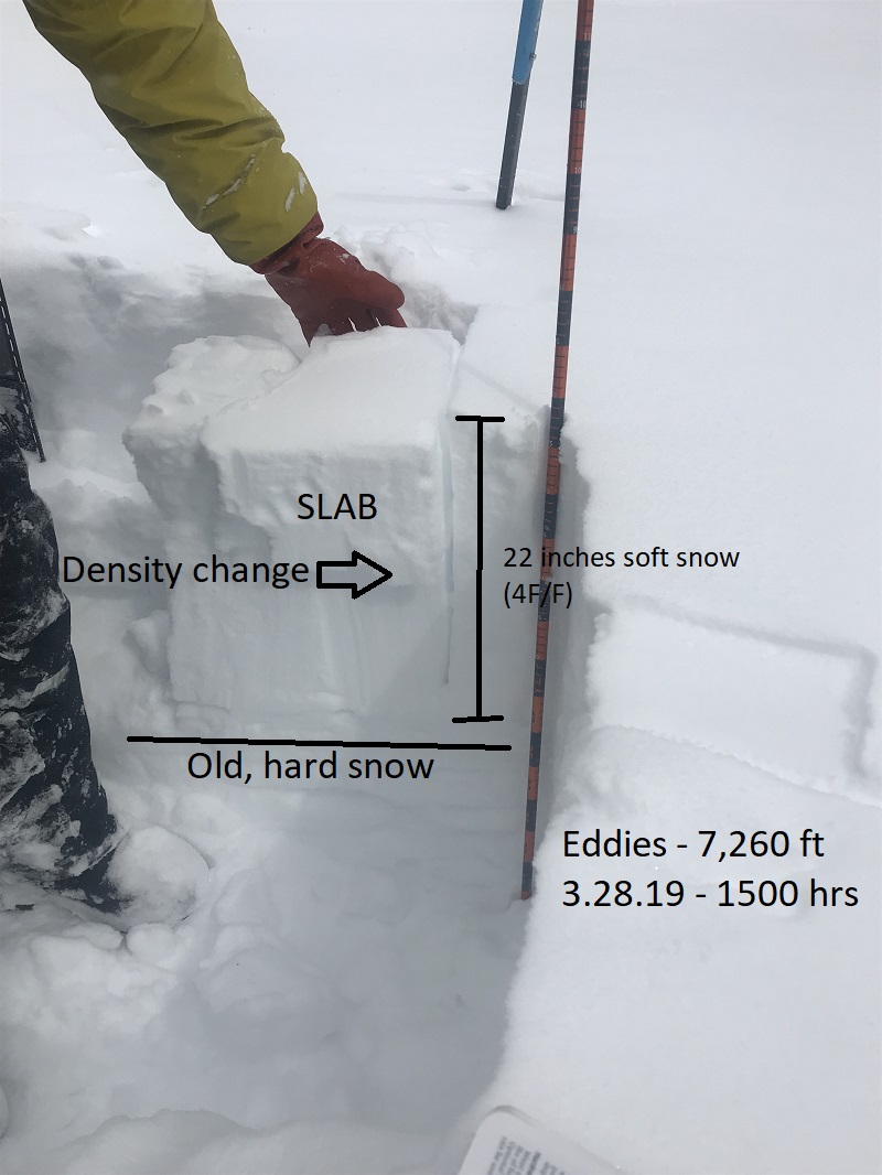
- New snow: 22 inches at 7,260 feet (storm total from past week).
- Average Height of Snow: 116 inches (9.6 feet)
- Wind: Southeasterly, moderate to strong, gusty. Active wind loading on westerly and northerly aspects. Human triggered avalanches possible. Active cornice formation.
- Precip: Steady, small, light flakes / < 1 inch an hour from 0500 to 1800 hours / 3-6 inches accumulation
- Boot Pen: 1 - 2 feet / Ski Pen: 6 - 10 inches
- Air Temp: High of 30 deg F
- Notes: Slabby where wind affected. Weak layer at density change 8-10 inches deep. Giant cornices along some ridgelines. On the east side of the forecast area, the groomer cut a small slope and triggered a 6' x 6' wind slab, approximately 1 foot deep.

Weather and Current Conditions
Weather Summary
A general clearing trend is in effect today. Precipitation and wind will taper this morning and dry weather to follow. The weekend looks sunny and nice, albiet short lived. A low moves toward the coast Sunday. Chances are good for showers late Sunday and Monday. The entire week will host a similar pattern of unsettled weather. Your prematurely placed lawn furniture might not turn white, but it will stay wet for the near future.
24 Hour Weather Station Data @ 3:00 AM
| Weather Station | Temp (°F) | Wind (mi/hr) | Snow (in) | Comments | ||||||||
|---|---|---|---|---|---|---|---|---|---|---|---|---|
| Cur | Min | Max | Avg | Avg | Max Gust | Dir | Depth | New | Water Equivalent | Settlement | ||
| Mt. Shasta City (3540 ft) | 33 | 32 | 38 | 34 | 1 | N | ||||||
| Sand Flat (6750 ft) | 24 | 22 | 32 | 27 | 151 | 6 | n/a | 1 | ||||
| Ski Bowl (7600 ft) | 17.5 | 17.5 | 28.5 | 23 | 189.6 | 6.5 | 0.96 | 1.1 | ||||
| Gray Butte (8000 ft) | 19 | 18.5 | 26.5 | 22 | 10 | 25 | WNW | |||||
| Castle Lake (5870 ft) | Station not responding | |||||||||||
| Mount Eddy (6509 ft) | 21 | 20 | 30 | 25.5 | 1 | 11 | SSE | 149.7 | 4 | 1 | ||
| Ash Creek Bowl (7250 ft) | ||||||||||||
| Ash Creek Ridge (7895 ft) |
Two Day Mountain Weather Forecast
Produced in partnership with the Medford NWS
| For 7000 ft to 9000 ft | |||
|---|---|---|---|
|
Friday (4 a.m. to 10 p.m.) |
Friday Night (10 p.m. to 4 a.m.) |
Saturday (4 a.m. to 10 p.m.) |
|
| Weather | Chance of snow showers in the morning, then becoming mostly cloudy, clearing. Snow level near 3,800 feet. | Partly cloudy, clearing. | Sunny, then becoming partly cloudy. |
| Temperature (°F) | 38 | 25 | 43 |
| Wind (mi/hr) | West 10-15 | West/Northwest 5-10 | Variable 0-5 |
| Precipitation SWE / Snowfall (in) | / < .5 | / 0 | / 0 |
| For 9000 ft to 11000 ft | |||
| Friday | Friday Night | Saturday | |
| Weather | Chance of snow showers in the morning, then becoming mostly cloudy, clearing. Snow level near 3,800 feet. | Partly cloudy, clearing. | Sunny, then becoming partly cloudy. |
| Temperature (°F) | 12 | 12 | 20 |
| Wind (mi/hr) | West 15-25 | West/Northwest < .5 | Variable 5 |
| Precipitation SWE / Snowfall (in) | / < .5 | / 0 | / 0 |
Season Precipitation for Mount Shasta City
| Period | Measured (in) | Normal (in) | Percent of Normal (%) |
|---|---|---|---|
| From Oct 1, 2023 (the wet season) | 35.22 | 35.07 | 100 |
| Month to Date (since May 1, 2024) | 5.69 | 5.57 | 102 |
| Year to Date (since Jan 1, 2024) | 26.81 | 19.86 | 135 |

