

You are here
Avalanche Forecast for 2021-02-07 06:30
- EXPIRED ON February 8, 2021 @ 6:30 amPublished on February 7, 2021 @ 6:30 am
- Issued by Ryan Sorenson - Mount Shasta Avalanche Center
Bottom Line
Avalanche danger is low. Isolated wind slabs may still be found on protected leeward slopes. More northwesterly wind will continue to gouge into the existing snowpack today. Mixed and variable snow surfaces remain. Higher elevation terrain will host firm conditions with plenty of exposed rock.


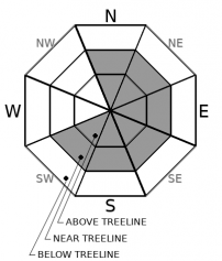
Avalanche Problem 1: Wind Slab
-
Character ?

-
Aspect/Elevation ?
-
Likelihood ?CertainVery LikelyLikelyPossible
 Unlikely
 -
Size ?HistoricVery LargeLargeSmall

Overall, avalanche danger is low. Northwesterly winds have blasted any exposed terrain. Warm daytime temperatures with colder nights have allowed the snowpack to settle and lock in place. Continue to watch for wind slabs. Blowing snow today may still form new ones. Isolated colder north and/or easterly slopes that could host moderate wind-speeds are most suspect. Be willing to step back into safer terrain if you experience cracking and blocking within the snowpack.
Forecast Discussion
Bunny Flat has been moderately busy. However, the crowds have been ruly and respectful. We appreciate everyone's efforts at keeping the parking situation organized and manageable.
We had an excellent showing at yesterday's companion rescue. Thank's for coming out.
Recent Observations
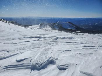
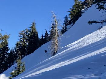
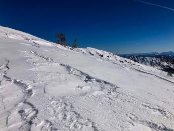
- Strong northwesterly winds have scoured, packed, and stripped any exposed snow over the past few days.
- Snow surfaces are a mixed bag of textures, including firm packed powder, sticky moist snow, and smooth spring-like melt-freeze.
- Reports from the Eddies indicate colder soft snow holding on northerly aspects with various wind packed layers.
- Winds have stripped the snowpack down to the rime layer (from 1/30), leaving icy patches and chicken heads in some exposed areas above treeline.
- Gray Butte wind: moderate to strong northwesterly wind yesterday afternoon with calmer winds last night.
- Max winds speed to 20 mi/hr, and 10 mi/hr average. Wind gusts were as high as 67 mi/hr.
- Near treeline temperatures Old Ski Bowl: Minimum: 37 ℉, Max: 50 ℉, Average: 44 ℉
Total snow heights:
- 72.7 inches (184 cm) - 7,600 feet, Old Ski Bowl
- 65.2 inches (165 cm) - 6,600 feet, Mt. Eddy
- 61.9 inches (157 cm) - 5,800 feet, Castle Lake
- 55.5 inches (140 cm) - 7,300 feet, Ash Creek Butte

Weather and Current Conditions
Weather Summary
We've moved into a relatively quiet weather pattern. A ridge of high pressure offshore is keeping the western United States dry with a pronounced northwesterly flow. Cold air dipping down from Canada is cooling the interior states. However, the Rocky Mountains are blocking this cold air from reaching California. We can expect normal temperatures for the next few days. Daytime highs will reach into the low 40's ℉ with lows in the upper 20's ℉. The strong northwest winds will continue to blow today and slowly decrease over the next few days.
24 Hour Weather Station Data @ 6:00 AM
| Weather Station | Temp (°F) | Wind (mi/hr) | Snow (in) | Comments | ||||||||
|---|---|---|---|---|---|---|---|---|---|---|---|---|
| Cur | Min | Max | Avg | Avg | Max Gust | Dir | Depth | New | Water Equivalent | Settlement | ||
| Mt. Shasta City (3540 ft) | 37 | 32 | 56 | 42 | 4 | |||||||
| Sand Flat (6750 ft) | 38 | 25 | 45 | 37 | 0.0 | 0 | 2 | 0 | Depth sensor not working. | |||
| Ski Bowl (7600 ft) | 42.5 | 34.5 | 50 | 43.5 | 72.8 | 0 | 0 | 1.7 | ||||
| Gray Butte (8000 ft) | 39.5 | 37 | 47 | 42 | 9 | 67 | NNW | |||||
| Castle Lake (5870 ft) | 39.5 | 33.5 | 46 | 39 | 61.9 | 0 | 8.5 | |||||
| Mount Eddy (6509 ft) | 39.5 | 37.5 | 46.5 | 41 | 3 | 7 | SE | 65.2 | 0 | 1.5 | ||
| Ash Creek Bowl (7250 ft) | 32.5 | 31.5 | 40 | 34 | 56.1 | 0 | 0.8 | |||||
| Ash Creek Ridge (7895 ft) | 30.5 | 29.5 | 36 | 31.5 | 18 | 30 | W | wind sensor rimed |
Two Day Mountain Weather Forecast
Produced in partnership with the Medford NWS
| For 7000 ft to 9000 ft | |||
|---|---|---|---|
|
Sunday (4 a.m. to 10 p.m.) |
Sunday Night (10 p.m. to 4 a.m.) |
Monday (4 a.m. to 10 p.m.) |
|
| Weather | Sunny | Partly cloudy | Mostly Sunny |
| Temperature (°F) | 40 | 28 | 42 |
| Wind (mi/hr) | Northwest 10-15 | Northwest 10-15 | West 5-10 |
| Precipitation SWE / Snowfall (in) | 0.00 / 0 | 0.00 / 0 | 0.00 / 0 |
| For 9000 ft to 11000 ft | |||
| Sunday | Sunday Night | Monday | |
| Weather | Sunny | Partly cloudy | Mostly sunny |
| Temperature (°F) | 30 | 28 | 28 |
| Wind (mi/hr) | Northwest 35-40 | Northwest 25-35 | West 20-25 |
| Precipitation SWE / Snowfall (in) | 0.00 / 0 | 0.00 / 0 | 0.00 / 0 |
Season Precipitation for Mount Shasta City
| Period | Measured (in) | Normal (in) | Percent of Normal (%) |
|---|---|---|---|
| From Oct 1, 2023 (the wet season) | 12.60 | 23.73 | 53 |
| Month to Date (since Apr 1, 2024) | 1.16 | 1.46 | 79 |
| Year to Date (since Jan 1, 2024) | 9.02 | 8.52 | 106 |

