

You are here
Avalanche Forecast for 2021-03-09 06:30
- EXPIRED ON March 10, 2021 @ 6:30 amPublished on March 9, 2021 @ 6:30 am
- Issued by Aaron Beverly - Mount Shasta Avalanche Center
Bottom Line
Avalanche danger will become high. Significant snow, productive winds, crusts, and weak layers will all combine today to create a variety of avalanche concerns. Traveling near or in avalanche terrain is not recommended. Natural and human-triggered avalanches will be likely.


Avalanche Problem 1: Wind Slab
-
Character ?

-
Aspect/Elevation ?
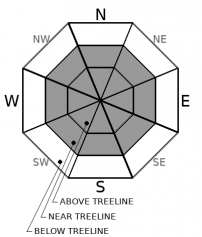
-
Likelihood ?CertainVery LikelyLikelyPossible
 Unlikely
 -
Size ?HistoricVery LargeLargeSmall

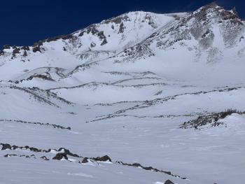
In the next 24 hours, 10-20 inches of new snow will fall. This will combine with yesterday's 10 inches. That's a significant amount of snow and weight being added to the snowpack. Productive southerly winds will pile that snow into thick wind slabs. These slabs will sit on top of a breakable crust and will not be well bonded to it. In addition, a weak layer exists under that crust. Wind slab avalanches will be likely today.
Traveling in or near avalanche terrain is not recommended. Pay attention to these signs: whumphing sounds, shooting cracks, and hollow snow. If you see or experience these things, winds slabs are nearby.
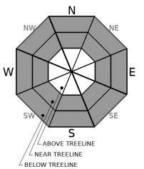
Avalanche Problem 2: Storm Slab
-
Character ?

-
Aspect/Elevation ?

-
Likelihood ?CertainVery LikelyLikelyPossible
Unlikely
-
Size ?HistoricVery LargeLargeSmall
On steep, wind protected slopes, human-triggered storm slabs are likely if the new snow becomes cohesive. Cold temperatures may prevent this, in which case, loose dry (slough) avalanches are more likely. Either way, the significant amount of snow from yesterday and today will not be well bounded to the underlying crust. The weak layer under this crust could also activate with the added weight.
Storm slabs form when new snow consolidates over a weaker layer or interface. The weak point can be snow that fell early in the storm or just a poor bond with the old snow surface.
Avalanche Problem 3: Loose Dry
-
Character ?

-
Aspect/Elevation ?
-
Likelihood ?CertainVery LikelyLikelyPossible
Unlikely
-
Size ?HistoricVery LargeLargeSmall
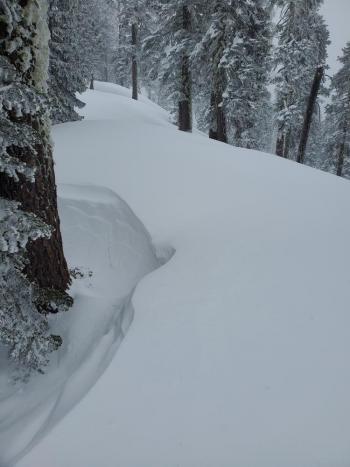
A loose dry avalanche (slough) is the release of unconsolidated snow. Sloughs were easily produced yesterday and are likely today on very steep, unsupported slopes. They could be on the large side. They are not usually as hazardous as slab avalanches but can carry you into terrain traps or over cliffs.
Forecast Discussion
The weak layer that exists within the storm snow from Saturday is something to keep an eye on. It is not clear how widespread it is, but based on what was seen on Sunday and Monday, it very well could be. That layer lies between two crusts and is not well bonded to the crust it sits on. Pay attention to this over the next few days. Cold temperatures will not allow it to strengthen and could cause facets to form.
Recent Observations
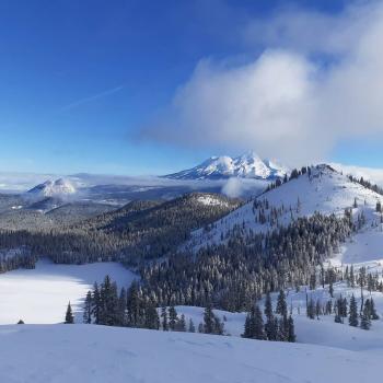
There is 79 inches of snow at 7,600 ft on Mount Shasta. In the last 24 hours, 10 inches of snow has fallen near treeline. West/southwest winds have averaged 11 mi/hr and gusted up to 37. The mean temperature was 18 ºF.
Oddly, the Eddy weather stations indicate very little snow fell west of I-5.
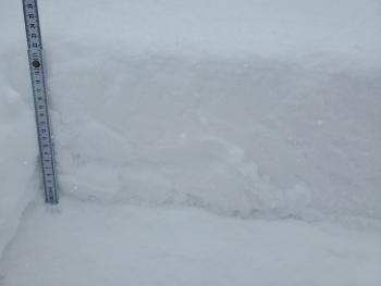
Sunday, a widespread sun/melt-freeze crust formed over Saturday's storm snow. New snow yesterday was not well bonded to it. Sloughs were easy to trigger. A weak layer exists between it and the hard snow surface prior to Saturday.
Weather and Current Conditions
Weather Summary
A winter storm warning is in effect until 10 a.m. Wednesday.
A pronounced low pressure system offshore will bring cold temperatures, low wind chills, and significant snow to the area today and tonight. Forecasted snow has almost doubled since yesterday. Expect 10-20 inches over the next 24 hours. It'll be snowing in Dunsmuir. South/southwest winds will be moderate to strong.
A few more inches could fall tomorrow as the tail end of the storm passes through. Drier conditions will set in until Sunday.
24 Hour Weather Station Data @ 5:00 AM
| Weather Station | Temp (°F) | Wind (mi/hr) | Snow (in) | Comments | ||||||||
|---|---|---|---|---|---|---|---|---|---|---|---|---|
| Cur | Min | Max | Avg | Avg | Max Gust | Dir | Depth | New | Water Equivalent | Settlement | ||
| Mt. Shasta City (3540 ft) | 31 | 31 | 39 | 33.5 | 3 | ESE | ||||||
| Sand Flat (6750 ft) | 20 | 20 | 25 | 23 | Snow sensor down | |||||||
| Ski Bowl (7600 ft) | 16 | 15.5 | 21 | 18 | 79.1 | 10.4 | 0.71 | 0 | ||||
| Gray Butte (8000 ft) | 15 | 14.5 | 20 | 17 | 12 | 37 | WSW | |||||
| Castle Lake (5870 ft) | 21.5 | 21.5 | 34 | 25.5 | 66.5 | 3.9 | 0 | |||||
| Mount Eddy (6509 ft) | 18.5 | 18.5 | 27.5 | 22 | 2 | 5 | SSE | 63.8 | 2.1 | 0 | ||
| Ash Creek Bowl (7250 ft) | 17.5 | 16.5 | 22.5 | 19 | 67.1 | 8.4 | 0 | |||||
| Ash Creek Ridge (7895 ft) | 13.5 | 13.5 | 19.5 | 16 | 10 | 43 | S | wind sensor rimed |
Two Day Mountain Weather Forecast
Produced in partnership with the Medford NWS
| For 7000 ft to 9000 ft | |||
|---|---|---|---|
|
Tuesday (4 a.m. to 10 p.m.) |
Tuesday Night (10 p.m. to 4 a.m.) |
Wednesday (4 a.m. to 10 p.m.) |
|
| Weather | Snow showers. The snow could be heavy at times. Widespread blowing snow, mainly between 10 a.m. and 1 p.m. Chance of precipitation is 90%. | Snow showers, mainly before 10 p.m. The snow could be heavy at times. Areas of blowing snow. Chance of precipitation is 90%. | Snow showers likely, mainly after 10 a.m. Mostly cloudy. Chance of precipitation is 70%. |
| Temperature (°F) | 25 | 19 | 26 |
| Wind (mi/hr) | South 10-15 | South 10-15 | South 5-10 |
| Precipitation SWE / Snowfall (in) | 1.00 / 6-10 | 0.30 / 3-5 | 0.32 / 2-4 |
| For 9000 ft to 11000 ft | |||
| Tuesday | Tuesday Night | Wednesday | |
| Weather | Snow showers. The snow could be heavy at times. Widespread blowing snow. Windy. Low wind chills. Chance of precipitation is 90%. | Snow showers, mainly before 10 p.m. The snow could be heavy at times. Widespread blowing snow. Windy. Low wind chills. Chance of precipitation is 90%. | Snow showers, mainly between 10 a.m. and 4 p.m. Chance of precipitation is 80%. |
| Temperature (°F) | 12 | 7 | 11 |
| Wind (mi/hr) | Southwest 25-30 | Southwest 25-30 | South 10-15 |
| Precipitation SWE / Snowfall (in) | 1.00 / 11-15 | 0.30 / 3-5 | 0.32 / 3-5 |
Season Precipitation for Mount Shasta City
| Period | Measured (in) | Normal (in) | Percent of Normal (%) |
|---|---|---|---|
| From Oct 1, 2023 (the wet season) | 14.27 | 31.46 | 45 |
| Month to Date (since Apr 1, 2024) | 0.69 | 1.96 | 35 |
| Year to Date (since Jan 1, 2024) | 10.69 | 16.25 | 66 |

