

You are here
Avalanche Advisory for 2013-02-16 01:34:27
- EXPIRED ON February 17, 2013 @ 1:34 amPublished on February 16, 2013 @ 1:34 am
- Issued by -
Bottom Line
Overall, avalanches are unlikely today in the forecast area. A variety of conditions will can be found out there with most areas trending on the firm side. Wind slabs have bonded well to the widespread crust layer and are not a concern. A thick layer of facets still exists below our thick crust, however we do not have any slabs above this layer from our observations. With plentiful sunshine, any southerly aspect should warm nicely and any instability will be limited to roller balls during the warmest portion of the day. Other aspects from the top 180 degrees of the compass will remain firm and funky!


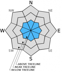
Avalanche Problem 1: Wind Slab
-
Character ?

-
Aspect/Elevation ?
-
Likelihood ?CertainVery LikelyLikelyPossible
 Unlikely
 -
Size ?HistoricVery LargeLargeSmall

Recent Observations
Weather Observations (last 24 hours): In Mt. Shasta City at 0500, we have clear skies and a current temperature of 28 F.
On Mt. Shasta: In the Old Ski Bowl (7,600') on the south side of Mt. Shasta, we have a current temperature of 34 F. Snow on the ground totals 97" inches with no new snow and little settlement. Temperatures have ranged from 27 F to 47 F in the last 24 hours. At Grey Butte (8,000') on the south side of Mt. Shasta winds averaged 15 mph from the ENE with a max gust of 49 from the E. The current temperature is 32 F and temps have ranged 30 F to 39 F.
Castle/Mt. Eddy: Castle Lake - Castle Lake is hosting a current temp of 37 F. In the last 24 hours temperatures have ranged from 29 F to 40 F. Snow depth measures 45" inches with no new snow and little settlement. On Mt Eddy, we have 61" inches of snow with no new snow and little settlement. The current temperature reads 32 F with temps ranging from 31 F to 39 F in the last 24 hours. Winds have been SE, averaging 2 mph and gusting to 11 mph from the SE.
Weather and Current Conditions
Weather Summary
 SXUS46 KMFR 151100
 RECMFR

 FORECAST FOR MOUNT SHASTA RECREATIONAL AREA
 NATIONAL WEATHER SERVICE MEDFORD, OR
 300 AM PST FRI FEB 15 2013

 CAZ082-160400-
 SOUTH CENTRAL SISKIYOU COUNTY-
 300 AM PST FRI FEB 15 2013

 .TODAY...SUNNY. HIGHS IN THE LOWER TO MID 50S. SOUTHEAST WINDS
 5 TO 10 MPH.
 .TONIGHT...MOSTLY CLEAR. LOWS IN THE MID 20S TO MID 30S. SOUTH
 WINDS 5 TO 10 MPH.
 .SATURDAY...PARTLY CLOUDY. HIGHS IN THE LOWER TO MID 50S. LIGHT
 WINDS BECOMING WEST AROUND 5 MPH IN THE AFTERNOON.
 .SATURDAY NIGHT...PARTLY CLOUDY IN THE EVENING THEN BECOMING
 MOSTLY CLOUDY. LOWS IN THE MID 20S TO LOWER 30S.
 .SUNDAY...COOLER. SUNNY IN THE MORNING THEN BECOMING PARTLY
 CLOUDY. HIGHS IN THE LOWER TO MID 40S.

 .EXTENDED...
 .WASHINGTONS BIRTHDAY...MOSTLY CLOUDY. CHANCE OF SNOW IN THE
 AFTERNOON AND EVENING. LOWS IN THE 20S. HIGHS 35 TO 45.
 .TUESDAY...SNOW SHOWERS. LOWS 15 TO 25. HIGHS 25 TO 35.
 .WEDNESDAY...MOSTLY CLOUDY. SNOW SHOWERS LIKELY...THEN CHANCE OF
 SNOW SHOWERS IN THE AFTERNOON AND EVENING. LOWS 15 TO 25. HIGHS
 25 TO 35.
 .THURSDAY...MOSTLY CLOUDY. CHANCE OF SNOW SHOWERS...THEN CHANCE
 OF SNOW IN THE AFTERNOON AND EVENING. LOWS 15 TO 25. HIGHS 25 TO
 35.

 &&
   TODAY        TEMPERATURE   /   WIND (MPH)
  6000 FEET         47        /    SW  10
 10000 FEET         34        /    SW  15
 14000 FEET         21        /    SW  25

   SNOW LEVEL FORECAST

 TODAY............9500 FEET.
 TONIGHT..........9500 FEET.
 SATURDAY.........8000 FEET.
 SATURDAY NIGHT...6000 FEET.
 SUNDAY...........4500 FEET.

 THIS PRODUCT IS ISSUED ONCE A DAY. FOR THE LATEST INFORMATION
CHECK THE MORE RECENT FORECAST FOR SOUTH CENTRAL SISKIYOU COUNTY | 0600 temperature: | 34 |
| Max. temperature in the last 24 hours: | 47 |
| Average wind direction during the last 24 hours: | ENE |
| Average wind speed during the last 24 hours: | 15 mi/hr |
| Maximum wind gust in the last 24 hours: | 49 mi/hr |
| New snowfall in the last 24 hours: | 0 inches |
| Total snow depth: | 97 inches |

