

You are here
Avalanche Advisory for 2016-03-26 07:01:10
- EXPIRED ON March 27, 2016 @ 7:01 amPublished on March 26, 2016 @ 7:01 am
- Issued by Jon Dove - Shasta-Trinity National Forest
Bottom Line
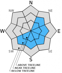
The strong northwest flow aloft continued yesterday. This created some small to medium sized wind slabs/pillows in isolated areas near and above treeline. MODERATE avalanche danger exist for these wind loaded pockets on SW-S-SE-E-NE facing slopes. Human trigger of lingering wind slabs along the tops of bowls, ridgelines, near rock outcroppings, and steep chutes may be possible. LOW avalanche danger exist below treeline. Evaluate snow and terrain carefully.


Avalanche Problem 1: Wind Slab
-
Character ?

-
Aspect/Elevation ?
-
Likelihood ?CertainVery LikelyLikelyPossible
 Unlikely
 -
Size ?HistoricVery LargeLargeSmall

A strong northwest flow was quite evident yesterday with the characteristic lenticular cloud capping Mount Shasta. The down wind side of the cloud curled under indicating an eddy on the southern side of the mountain. It was fun to watch from town, but being up in the midst of that tempest would have been epic. These winds, and the resulting "eddies" have mostly sublimated the snow, simply blowing it away. Most areas seemed very wind scoured limiting any chance for snow instabilities. However, some small to medium sized wind pillows and slabs may have formed in protected areas not directly affected by the winds. These areas will be found primarily on SW-S-SE-E-NE facing aspects near and above treeline. Areas along ridge lines, near rock outcroppings, convexities on the edge of moraines, and the tops of steep chutes will have the most potential to harbor wind loaded instabilities. The most concern for these potentially unstable pockets of wind loading will be near and above treeline on Mt Shasta.
Forecast Discussion
A warm front will move inland from the coast today bringing increasing clouds this afternoon with a chance for light precipitation late in the day into tonight. We will be at the southern edge of this system, and precipitation amounts will be light at best. Total water amounts are predicted to reach a paltry 0.03 inches with this "storm". A cold front will move in behind this system during the night lowering snow levels. For today, the snow levels increase to around 7,000 feet this afternoon, then drop to around 5,000 feet overnight. By Sunday morning clouds thin out a bit before the next front begins to move over the area later in the day. Clouds will increase, as will the chance for some precipitation. The upper level low pressure on Sunday evening will bring a cold air mass aloft dropping snow levels to 4,000-4,500 feet. Once again, precipitation amounts associated with system will be light due to the majority of the energy flowing to the north of our area. New snow amounts of only around an inch are possible with the Sunday/Monday disturbance. Winds will remain moderate shifting from an easterly direction to the northwest then, west. Ridge tops, and other exposed areas could see winds of 30-40 mph with some higher gusts possible.
THIS SEASON PRECIPITATION for MT SHASTA CITY: Since October 1st (the wet season), we have received 36.72 inches of water, normal is 34.65 inches, putting us at 105% of normal. For the month of March we've received 11.20 inches of water, normal is 5.15 inches, putting us at 217% of normal, and finally... for the year of 2016 we've received 27.23 inches of water, normal is 19.44 inches, putting us at 140% of normal.
Recent Observations
For the third straight day strong northwest winds howled across our forecast area. At higher elevations the winds have been strong enough to simply sublimate the snow, blowing it away instead of depositing it somewhere. This has limited the development of wind slabs and pillows. That being said, they do exist is some isolated, protected areas near and above treeline. Observations made yesterday to the east of Mount Shasta revealed the presence of wind slab formations, but they did not seem unstable. Any instabilities from wind loading over the past few days will have been immediately during development. There has been no sustaining weakness associated with wind slabs/pillows, and the warmer temperatures will encourage bonding with underlying snow. Areas of concern for today will lie in isolated wind protected zones on leeward NE-E-SE-S-SW aspects along ridge tops, around rock outcroppings, the edge of moraines along their convexities, the steep tops of chutes, and depressions. Observations of the snowpack below treeline revealed a layer of corn snow development on top of softer, dryer snow, especially in shaded areas. In general the snowpack is in a state of gradual consolidation and is bonding well. It is fairly safe out there except for those isolated pockets affected by the recent wind events. Keep your eyes peeled for any evidence of wind loading such as cornice formations, snow ribs behind trees, rounded hollow sounding hard slabs, etc. Avoid these formations on slopes 37 degrees and steeper.
Observations made at Castle Lake a couple of days ago noted melting lake edges. This is actually a serious concern... if one gets caught or knocked off their feet in any type of avalanche and the slide makes it's way down to lake level... well, lets just say it's very difficult if not impossible to dig somebody out from underneath slushy water. In other words, melting lake edges are horrible terrain traps! Be careful up there.
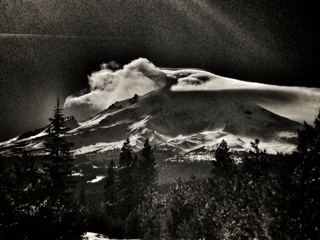
Strong Northwest winds created a lenticular cloud common on Mount Shasta. Note the curling nature of the cloud on the southerly, down wind side (left side) indicating an eddy:
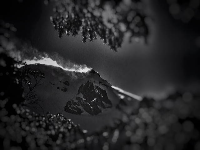
Snow banners rippling off of the ridge tops was prevalent across the forecast area:
Note the snow ribs that have formed behind trees (lower right) due to Northwest winds in near treeline areas on the east side of the forecast area:
A note for all climbers and skiers heading up onto the upper mountain: Rime ice has formed on most rock outcroppings and is currently very thick. As warm days ensue, rime ice will flake off and fall down onto the slopes below. Rime ice chunks can be very large and very hard, enough to potentially kill you or cause serious injury. Beware of this hazard. Keep your eyes up slope as you climb and move laterally to avoid falling chunks of ice. If continuous ice fall is encountered turn around and descend to climb another day!
-----------------------------------------------------------------------------------------------------------------------------------------------------------
LOCAL AREA ROAD, NORDIC, AND SNOWMOBILE PARK STATUS:
The Sand Flat cross country ski trails are in good shape and ready for your cross country skis and snow shoes. These are backcountry routes marked with blue diamonds on trees. Trails are not groomed. Snow shoers, please blaze a parallel trail to cross country skiers staying out of the skin track. These trails can be accessed via the Everett Memorial Highway. Thank you, and enjoy!
The Mt. Shasta Nordic Center is open! These beautiful, groomed trails can be accessed via the Ski Park Highway. http://www.mtshastanordic.org
The Pilgrim Creek & Deer Mountain Snowmobile Parks are open! Trails have not been groomed in the past week and a half due to constant deep snow fall. Head to our "Education" tab on our website and find the snowmobile section for trail information, grooming status, and other sledder resources.
The Castle Lake Road is OPEN. The Everitt Memorial Highway is OPEN. The Castle Lake and Everitt Hwy are plowed year round to the trailheads. The roads are not always first priority, so your dawn patrol powder mission might be ceased if the plow has not made it up yet. Siskiyou County does a great job keeping the roads clear and be respectful of the plow drivers if you encounter them. If you get to Bunny Flat before or during when the plow is there, please park on the uphill, LEFT side of the parking lot as you drive in. This is uphill and lookers right of the bathrooms. Thank You!
The Five Red Flags of Avalanche Danger any time of year include: 1) Recent/current avalanche activity 2) Whumphing sounds or shooting cracks 3) Recent/current heavy snowfall 4) Strong winds transporting snow 5) Rapid warming or rain on snow.
Weather and Current Conditions
Weather Summary
Good Morning! In Mt Shasta City at 0500, we have a current temperature of 33 F, four degrees cooler than yesterday at this time. Skies are clear with calm wind.
On Mt Shasta (South Side) in the last 24 hours...
Old Ski Bowl - 7,600 feet, the current temperature is 27 degrees F. Snow on the ground totals 157 inches with no new snow and 2 inches of settlement. Temperatures have ranged from 27 F to 43 F.
Gray Butte - 8,000 feet, the current temperature is 29 degrees F. Temperatures have ranged from 27 F to 40 F. The northwest winds have shifted to east/southeast, decreasing to an average of 5-10 mph with gusts to 49 mph in the last 24 hours.
Mt Eddy Range (West side of Interstate-5)...
Castle Lake - 5,600 feet, the current temperature is 30 degrees F. Temperatures have ranged from 29 F to 45 F. Snow on the ground totals 74 inches with no new snow and 2 inches of settlement.
Mt Eddy - 6,500 feet, the current temperature is 34 degrees F. Temperatures have ranged from 29 F to 40 F. Snow on the ground measures 86 inches with no new snow and 2 inches of settlement. Winds have been south east in nature with an average of 3 mph, and a maximum gust of 15 mph, SE.
Always check the weather before you attempt to climb Mt Shasta. Further, monitor the weather as you climb. Becoming caught on the mountain in any type of weather can compromise life and limb. Be prepared.
| 0600 temperature: | 27 |
| Max. temperature in the last 24 hours: | 42 |
| Average wind direction during the last 24 hours: | East/southeast |
| Average wind speed during the last 24 hours: | 5-10 mi/hr |
| Maximum wind gust in the last 24 hours: | 49 (Gray Butte) mi/hr |
| New snowfall in the last 24 hours: | 0 inches |
| Total snow depth: | 100 inches |
Two Day Mountain Weather Forecast
Produced in partnership with the Medford NWS
| For 7000 ft to 9000 ft | |||
|---|---|---|---|
|
Saturday (4 a.m. to 10 p.m.) |
Saturday Night (10 p.m. to 4 a.m.) |
Sunday (4 a.m. to 10 p.m.) |
|
| Weather | Partly cloudy with increasing clouds. 30% chance of rain late this afternoon. | Mostly cloudy with a 30% chance of rain before midnight, then mostly cloudy. Decreasing clouds. | Partly sunny with increasing clouds in the afternoon. 20% chance of snow showers. |
| Temperature (°F) | 48 | 32 | 43 |
| Wind (mi/hr) | Northeast shifting to West this afternoon 5-10 mph with gusts to 25 | West 5-10 mph | West around 5 mph increasing to 10-15 mph in the afternoon |
| Precipitation SWE / Snowfall (in) | / 0 | / 0 | / 0 |
| For 9000 ft to 11000 ft | |||
| Saturday | Saturday Night | Sunday | |
| Weather | Partly cloudy with increasing clouds. 30% chance of snow late this afternoon. Windy | Mostly cloudy with a 30% chance of snow before midnight, then mostly cloudy. Decreasing clouds. Windy | Partly sunny with a 20% chance of snow showers. Windy with wind chill values as low as -9 |
| Temperature (°F) | 26 | 25 | 19 |
| Wind (mi/hr) | North/northwest 25-30 mph with gusts to 40 mph | West/northwest 0-.5 | West 25-30 mph |
| Precipitation SWE / Snowfall (in) | / 0-.5 | / 0-.5 | / 0 |

