

You are here
Avalanche Advisory for 2016-04-16 07:11:33
- EXPIRED ON April 17, 2016 @ 7:11 amPublished on April 16, 2016 @ 7:11 am
- Issued by Nick Meyers - Shasta-Trinity National Forest
Bottom Line
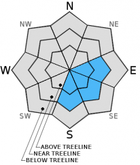
A couple inches of new snow on Wednesday & Thursday accompanied by high NW-N-NE winds have created small/medium sized cornices and small wind slabs on Mt Shasta. Cornices have been failing and causing point release avalanches on slopes below. Warming today will allow for human & natural trigger of lingering cornices and/or loose wet point release slides within new snow layers. Expect overall MODERATE danger to prevail for avalanche terrain near and above treeline.


Avalanche Problem 1: Loose Wet
-
Character ?

-
Aspect/Elevation ?
-
Likelihood ?CertainVery LikelyLikelyPossible
 Unlikely
 -
Size ?HistoricVery LargeLargeSmall

A solid freeze last night with temps in the teens to low twenties will keep any loose wet slides in check for the morning hours. However, temps this morning are climbing high with 0500 temps already 7 F to 17 F degrees warmer than yesterday at this time. Continued warming today is likely to cause some instability within the top, new layers of snow. Steeper southeast aspects off Casaval, in Powder and Sun bowl, all below 10,000 feet in elevation will be the most likely areas to see small to medium sized point release, loose-wet slides triggered by skiers, climbers, rocks, ice or failing cornices. Because of the small amount and lack of even distribution of the new storm snow received over the past couple days, I'm not expecting to see any large scale wind slabs or large loose wet slides. That said, wind pillows up to 8" to 12" deep have been observed. Most of these deeper wind deposits have been in non-threatening areas like low angle gully bottoms, but not limited to. As you gain near and above treeline avalanche terrain, it's going to be up to you to identify wind loaded areas and avoid them entirely or tread lightly!
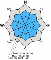
Avalanche Problem 2: Cornice
-
Character ?

-
Aspect/Elevation ?
-
Likelihood ?CertainVery LikelyLikelyPossible
Unlikely
-
Size ?HistoricVery LargeLargeSmall
Rapid cornice growth was observed over the past few days due to high northwest/north/northeast winds. Isolated cornices grew quickly but also failed quickly, thus larger lingering cornices have been few and far between. The aforementioned cornice failures have triggered small point release slides that have traveled partially down slopes below. Large cornices or cornices triggering large wind slabs have not been observed and are not expected today. In the perfect situation however, enough snow could fail to entrain a skier or climber, taking them down the slope. Combine with a terrain trap and burial is possible. Due to winds from multiple directions, expect wind loading and cornices on multiple aspects! Ridgelines are likely scoured, but just below or immediately off ridgelines is where you'll find the cornice formations. Stay away from the edge. Identify terra firma by looking for trees or rock protruding through the snow, or stay on the scoured, firm snow.
Forecast Discussion
Not much elaborating necessary today. Clear, sunny, warming temperatures and decreasing winds. Today and tomorrow will be very nice in the forecast area and on Mt Shasta. Even the upper mountain should be quite civilized. This does not mean caution should be thrown to the light northeasterly wind today. Pay attention, be safe, have fun.
THIS SEASON PRECIPITATION for MT SHASTA CITY: Since October 1st (the wet season), we have received 37.61 inches of water, normal is 37.07 inches, putting us at 101% of normal. For the month of April we've received 0.88 inches of water, normal is 1.61 inches, putting us at 54% of normal, and finally... for the year of 2016 we've received 28.12 inches of water, normal is 21.86 inches, putting us at 128% of normal.
Recent Observations
Yesterday opened up into splendid weather albeit some hefty winds blowing on the upper mountain. This was easily discernable by the giant plumes of blowing snow coming off Sargents Ridge and other areas of the mountain. Down below treeline, there was a nip to the air, but the sun was out in full force and winds were light. Many skiers were out and about for the day, though surprisingly, none of the folks I spoke to raved about the skiing conditions. "Meh..." was the word most described the skiing... hot, sticky powder scabs dispersed about and in gullies, scoured icy patches, small to medium size hard wind pillows. The snow needs a day or two of cooking for it to get back to a solid melt/freeze cycle. Temps have been overall cooler lately with sub-freezing temps at night, but as predicted, temps are beginning to rise drastically this morning with 5am temps already reporting 7 to 17 degrees warmer than yesterday at this time.
The south side of the mountain continued to see high north/northeast wind causing rapid and immediate cornice build-up and failures along ridgelines. These natural cornice failures resulted in small to medium point release style slides. These new cornice failures and resulting surface sluffs occurred off Casaval Ridge yesterday. The slides off Casaval were identical to the small cornice break/point release slide we saw in Sun Bowl the day prior. Winds blowing out of the north/northeast have loaded southerly facing slopes and also created small cornices along ridgelines in the past few days. Storm winds, a few days prior, blew out of the southwest/west so other aspects could also host small cornices and/or wind pillows/wind loaded areas. Overall, large scale wind slabs are unlikely and the only instability we've been seeing are these cornice failures initiating surface sluffs and traveling 3/4 of the way down the given slope. Most are not entraining enough snow to cause a backcountry skier or climber any trouble, but certainly could if combined with a terrain trap.
Today, while we have not see any loose-wet slides yet, warming temperatures could have some of the new surface snow on the move today. My guess is that skier triggered and perhaps some small natural slides are likely within the surface layers of the snowpack today. Steeper slopes below 10,000 feet on the southeast aspect of Casaval Ridge for example and other east/southeast/south aspects are going to be the most probable locations to encounter this avalanche problem. A few lingering cornices might also be sensitive to trigger. Do yourself and others a favor: stay back from the edge. Cornices are like rattlesnakes... How do most people get bit by rattlesnakes? Teasing them. How to most people trigger a cornice? Teasing them.
As the mountain begins to get more visitors, pay attention to your surrounding. Your sphere of influence becomes much larger when you have the ability to trigger a slide that could travel hundreds of yards, taking out a climber in a gully, another skier, or perhaps day hikers having lunch somewhere. Skiing is a fairly personal endevour, but not when others are around.
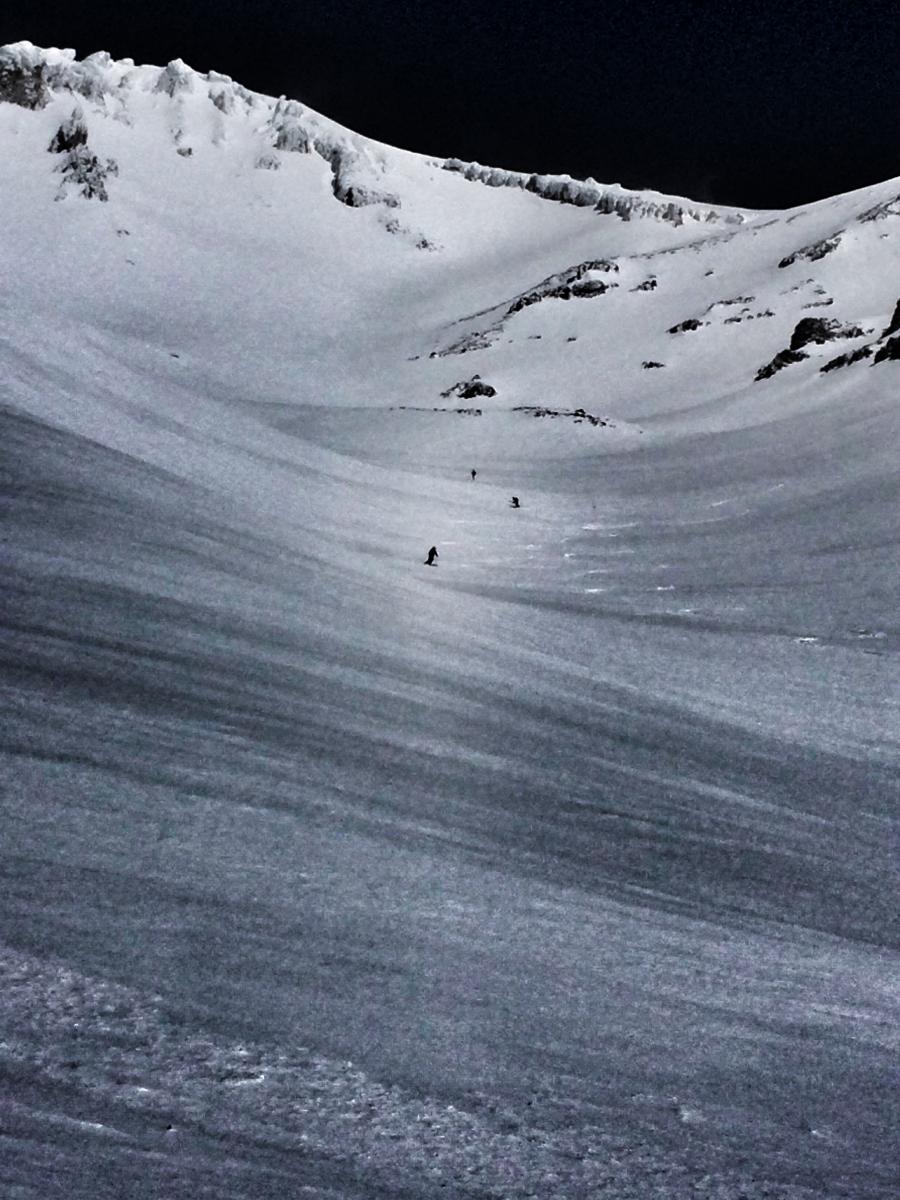
Skiers descending Avalanche Gulch to Helen Lake on 4.15.16. Notice the heavily rimed Redbanks and Trinity Chutes formations. This rime will flake off and fall down the slopes below on warm days. If you're climbing, wear a helmet and watch out for chunks of ice headed your way! / Photo: J Koster
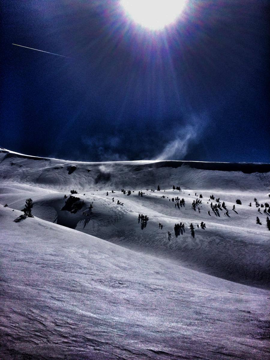
High northwest/north/northeast winds near and above treeline yesterday with plums of snow visible for most of the day. These winds caused rapid cornice growth and failure, initiating small point release style slides over the past two days. Some small lingering cornices could still remain. (4.15.16) / Photo: J Koster
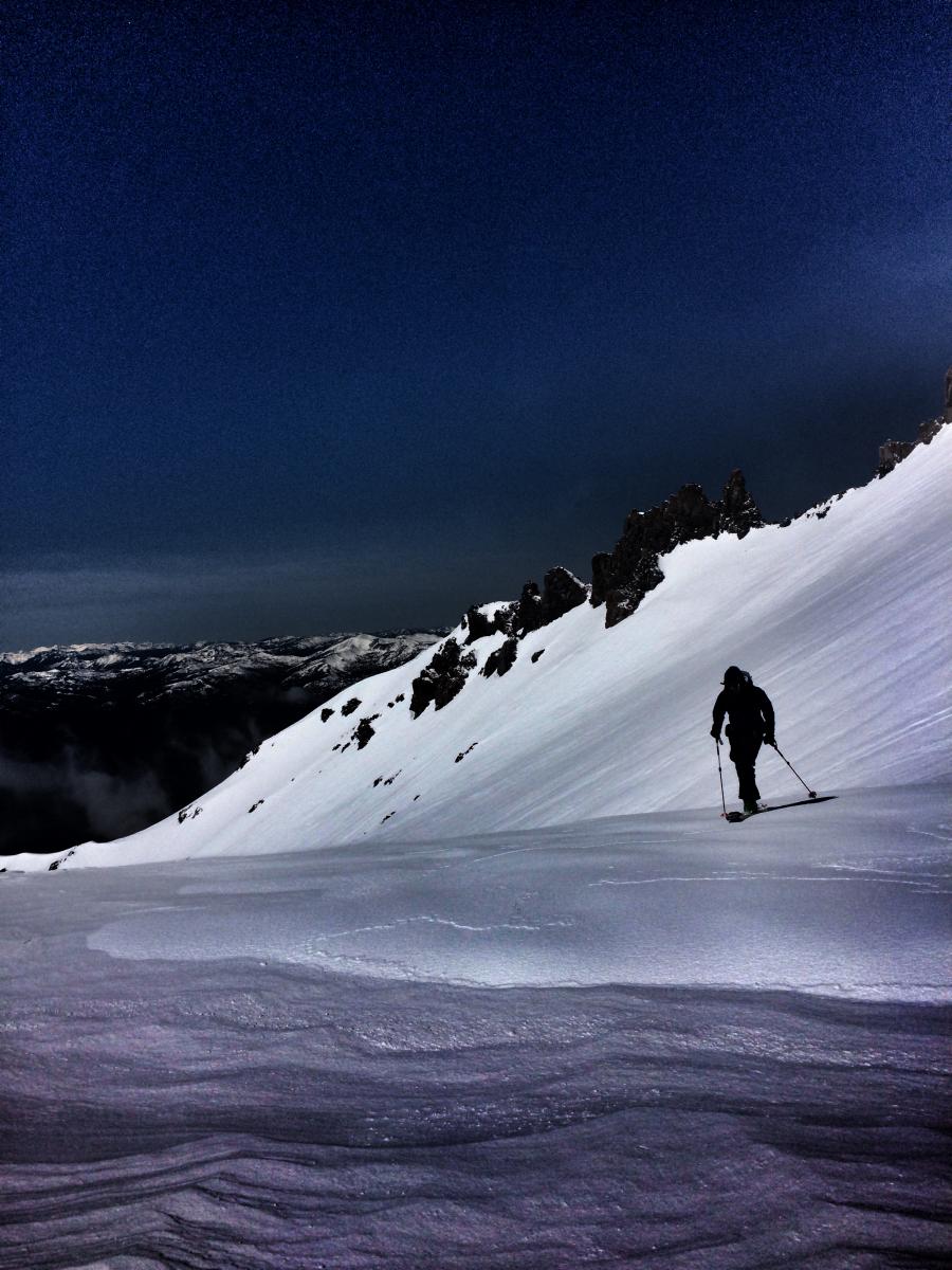
A skier tops out at Helen Lake on 4.15.16. Notice funky nature of snow with "scabs" of packed powder, scoured old snow and everything in between. / Photo: J Koster
-------------------------------------------------------------------------------------------------------------------------------------
Climbing Conditions: Current climbing conditions are good to great. Below are some things to think about when planning your trip this Spring:
- Avalanche Danger & Weather: You may encounter a variety of snow conditions during the spring time. Late season storms can bring fresh snow and high winds to the mountains. Avalanche danger can quickly spike due to new wind and storm slabs on top of icy, firm melt/freeze snow. Further, warm and sometimes downright hot days can create loose wet avalanches. Low danger in the cool morning hours may rise rapidly to higher danger during the afternoon hours on sunny aspects. These are two different avalanche problems associated with different weather patterns with both being possible during the same week, or even the same day. A beacon, shovel and probe continue to be essential, even during Spring time. Always check the avalanche advisory before starting your climb, and call the ranger station for the latest in weather and conditions. Spring time weather patterns can bring it all. The point is... you need to bring the appropriate attire to accommodate all weather conditions. Snow, rain, sun, wind... you can count on all of it on Shasta at some point during Spring time. Further, Mt Shasta can often host a cloud cap creating poor visibility conditions. DO NO climb into a white-out. It is very easy to wander off the WRONG side of Mt Shasta when on the upper mountain, >12,500 feet. This can create a long day and perhaps night for climber, party members, rescue resources and family. Play it safe.
- Firm and smooth snow (slide for life conditions): Snow conditions on Mount Shasta are great right now. That being said, the snow in the morning hours is very firm and very smooth. These types of conditions have caused serious injury in the past to those who slip, trip, or fall and fail to self-arrest as they slide. You MUST know how to self-arrest with an ice axe. This is one of your best defenses for a safe trip on Mt Shasta. Practice this and other climbing skills on small, short slopes in soft snow. If you fall, you must immediately self-arrest or you will take a long, sliding, tumbling fall resulting in serious injury or death. Along with your solid ice axe skills, know how to walk/climb with crampons on. It is easy to catch the front points of the crampon on the cuff of your pant leg resulting in a fall if you are not careful with each step.
- Rime Ice: What is rime ice? Rime ice forms on rocks, towers, etc. as super cooled water droplets freeze upon contact with a solid object. The ice grows into the wind taking on a cauliflower like appearance. The exposed rocks on Mt Shasta at higher elevations are currently plastered in rime ice. This hazard will diminish as the ice flakes off on warm days, but until then... HEADS UP! You absolutely should wear a helmet if climbing. As the days warm, chances increase of getting hit by falling ice until all of it falls off.
-----------------------------------------------------------------------------------------------------------------------------------------------------------
LOCAL AREA ROAD, NORDIC, AND SNOWMOBILE PARK STATUS:
The Sand Flat cross country ski trails are still covered in snow. A little bit of fresh snow has them in better shape currently, though they have been a little crusty before this last storm. These are backcountry routes marked with blue diamonds on trees. Trails are not groomed. Snow shoers, please blaze a parallel trail to cross country skiers staying out of the skin track. These trails can be accessed via the Everett Memorial Highway. Thank you, and enjoy!
The Mt. Shasta Nordic Center is CLOSED for the season. http://www.mtshastanordic.org
The Pilgrim Creek & Deer Mountain Snowmobile Parks are open, however there is currently no snow at these locations. One had to drive down the 19 road (Military Pass) to get to consistent snow before unloading. Head to our "Education" tab on our website and find the snowmobile section for trail information, grooming status, and other sledder resources.
The Castle Lake Road is OPEN. The Everett Memorial Highway is OPEN. The Castle Lake and Everett Hwy are plowed year round to the trailheads. The roads are not always first priority, so your dawn patrol powder mission might be ceased if the plow has not made it up yet. Siskiyou County does a great job keeping the roads clear. Be respectful of the plow drivers if you encounter them. If you get to Bunny Flat before or during when the plow is there, please park on the uphill, LEFT side of the parking lot as you drive in. This is uphill and lookers right of the bathrooms. Thank You!
The Five Red Flags of Avalanche Danger any time of year include: 1) Recent/current avalanche activity 2) Whumphing sounds or shooting cracks 3) Recent/current heavy snowfall 4) Strong winds transporting snow 5) Rapid warming or rain on snow.
Weather and Current Conditions
Weather Summary
Good Morning! In Mt Shasta City at 0500, we have a current temperature of 33 F, 4 degrees cooler than yesterday at this time. Skies are clear with calm wind.
On Mt Shasta (South Side) in the last 24 hours...
Old Ski Bowl - 7,600 feet, the current temperature is 33 degrees F. Snow on the ground totals 126 inches with no new snow and 2 inches settlement. Temperatures have ranged from 16 F to 41 F.
Gray Butte - 8,000 feet, the current temperature is 36 degrees F. Temperatures have ranged from 25 F to 46 F. Wind speeds are not available for Gray Butte at this time. The anemometer was taken down due to the need for repairs. Thank you for your understanding.
Mt Eddy Range (West side of Interstate-5)...
Castle Lake - 5,600 feet, the current temperature is 36 degrees F. Temperatures have ranged from 25 F to 46 F. Snow on the ground totals 43 inches with no new snow and 2 inches settlement.
Mt Eddy - 6,500 feet, the current temperature is 29 degrees F. Temperatures have ranged from 22 F to 39 F. Snow on the ground measures 56 inches with no new snow and one inch settlement. Winds have been southerly in nature with an average of 2-4 mph, and a maximum gust of 19 mph, SE.
Always check the weather before you attempt to climb Mt Shasta. Further, monitor the weather as you climb. Becoming caught on the mountain in any type of weather can compromise life and limb. Be prepared.
| 0600 temperature: | 27 |
| Max. temperature in the last 24 hours: | 43 |
| Average wind direction during the last 24 hours: | N/A |
| Average wind speed during the last 24 hours: | N/A mi/hr |
| Maximum wind gust in the last 24 hours: | N/A mi/hr |
| New snowfall in the last 24 hours: | 0 inches |
| Total snow depth: | 70 inches |
Two Day Mountain Weather Forecast
Produced in partnership with the Medford NWS
| For 7000 ft to 9000 ft | |||
|---|---|---|---|
|
Saturday (4 a.m. to 10 p.m.) |
Saturday Night (10 p.m. to 4 a.m.) |
Sunday (4 a.m. to 10 p.m.) |
|
| Weather | Sunny | Mostly clear | Sunny |
| Temperature (°F) | 56 | 39 | 21 |
| Wind (mi/hr) | Northeast 5-10 mph | East 5-10 mph | East 5-10 mph |
| Precipitation SWE / Snowfall (in) | / 0 | / 0 | / 0 |
| For 9000 ft to 11000 ft | |||
| Saturday | Saturday Night | Sunday | |
| Weather | Sunny, a bit breezy | Mostly clear | Sunny |
| Temperature (°F) | 33 | 36 | 37 |
| Wind (mi/hr) | North/Northeast 10-15 mph | Northeast 0 | Southeast 10-15 mph |
| Precipitation SWE / Snowfall (in) | / 0 | / 0 | / 0 |

