

You are here
Avalanche Advisory for 2013-03-16 06:44:14
- EXPIRED ON March 17, 2013 @ 6:44 amPublished on March 16, 2013 @ 6:44 am
- Issued by Nick Meyers - Shasta-Trinity National Forest
Bottom Line
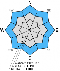
The avalanche danger for today is low for all aspects and elevations. We've seen a general cooling trend over the last two days and temperatures will remain similar to yesterday. All aspects below 8,000 feet will host soft, sticky snow with a low potential for loose-wet sloughs. Snow on slopes near and above treeline is making a transition to melt/freeze corn...supportable, however not fully mature... Mid elevation wet-loose activity has been low. Upper elevations will host wind packed powder and some small wind slabs in isolated areas with low potential to trigger.


Avalanche Problem 1: Wet Slab
-
Character ?

-
Aspect/Elevation ?
-
Likelihood ?CertainVery LikelyLikelyPossible
 Unlikely
 -
Size ?HistoricVery LargeLargeSmall

Loose-wet avalanches will be unlikely today with the cooler nighttime lows and daytime highs. However, release of wet unconsolidated snow or slush is possible for lower elevation, sunny slopes that are steeper than 40 degrees. Loose-wet slides typically start at a point and entrain snow as they move downhill. They generally are slow moving, but can contain enough mass to sweep a rider of their feet. For the past two days, temperatures have peaked at 1300.
Any concern lies in the top +/- 30cm of the snowpack. The bottom 15 cm of that 30 cm remains saturated and wet. Stability tests have resulted in some collapse of the wet layer, but with no propagation. While not impossible, the chance of loose-wet sloughs today remains low and isolated to only the warmest, southerly facing-low elevation, steep (>40) slopes.
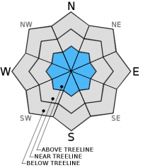
Avalanche Problem 2: Wind Slab
-
Character ?

-
Aspect/Elevation ?
-
Likelihood ?CertainVery LikelyLikelyPossible
Unlikely
-
Size ?HistoricVery LargeLargeSmall
Very isolated areas hosting small wind slabs of little consequence could exist at mid and upper elevations on Mt. Shasta and the Mt. Eddy area. Wind slabs will likely be unreactive to trigger.
Avalanche Problem 3: Cornice
-
Character ?

-
Likelihood ?CertainVery LikelyLikelyPossible
Unlikely
-
Size ?HistoricVery LargeLargeSmall
Cornice failure could be possible along Middle Peak at Castle Lake and other isolated areas. Use caution when traveling along ridgetops where cornices are present. They can often break back much further than expected. Always be sure you have terra-firma underneath your feet!
Recent Observations
Temperatures have cooled some today. Yesterday, the snow was supportable and hosted decent skiing mid-day on southerly facing slopes above treeline on Mt. Shasta. Below treeline, soft, mushy glop was the name of the game. The snow is freezing at mid and upper elevations at night and making its transition into mature corn. North facing aspects could potentially host some "dryer" snow at mid/upper elevations, but these areas will be limited to only the most cold and shady north aspects. Ash Creek Guard Station (East of Mt. Shasta) hit 70 F degrees yesterday and 26 F last night. On the mountain, temps hit 49 F in the Old Ski Bowl and 56 F at Caslte Lake (3 F / 5 F cooler than the day prior, respectively) with little wind. Lows last night reached freezing at Old Ski Bowl and Sand Flat.
A great video from the Gallatin Avalanche Center, Bozeman, MT demonstrating a loose-wet slide: http://www.youtube.com/watch?v=zWpRQzgtL3o&feature=share&list=PLXu5151nmAvT7gHqdNajDBGfGY4u5XMSL
Overall, no loose-wet avalanche activity has been seen or reported, except for the ob below reported on 3-14.
Local observation submitted yesterday, 3-14-13 from Castle Lake area: "Wet slide activity on northeast aspect, potential leg breaker, not burial depth however...Very warm, wet snowpack...not corn yet..."
This observation was similar to what was seen on Mt. Shasta...that is: a very wet and warm upper snowpack...we saw very little in the way of roller balls, pinwheels, wet-loose sloughs, etc on the mountain. Any wet-loose activity will be on low elevation, southerly aspects during mid-afternoon hours.
3-14-13...
Old Ski Bowl, 8,500 feet, 1500, 48 F, East facing - Consolidated, 30cm of new snow on top of old snowpack; bottom 15cm of new snow completely saturated with water and loose/slushy. ECTN-15...no propagation but collapse within saturated, wet/loose bottom 15cm of new snow from last week.
Old Ski Bowl, 9,300 feet, 1530, North Facing - Dry snow, wind slab up to 50cm deep on top of old snowpack, CTN (No fracture)
North side Mt. Shasta, 7,500 - 8,000 feet, NE aspect, very limited roller ball / pin wheel activity isolated to near rock outcrops on steeper slopes.
Weather and Current Conditions
Weather Summary
Temperatures are a degree or two cooler than yesterday as the weak cold front moves through the area today. While overnight temps have not been super cold, they have been cold enough to firm the snow up for the morning hours and help transition our snowpack into a melt/freeze cycle. Eventually we should get the beloved corn were famed for! Soft and sticky snow will likely continue however for lower elevation slopes.
Partly cloudy to mostly sunny skies will be above head today. A very low chance of precipitation for this afternoon exists, though it looks like Shasta remains a bit to far south for this one. Of most interest... near and above treeline winds will increase out of the northwest and peak tonight / tomorrow morning. Nothing major, but we should see winds NW 35-45 with gusts higher...and calming by later Sunday / Monday. Next best chance of winter weather is Tuesday, but snow levels look to be around 5,000 ft.
WEATHER STATIONS - (last 24 hours):
In Mt. Shasta City at 0500, we have clear skies and a current temperature of 39 F.
On Mt. Shasta: In the Old Ski Bowl (7,600') on the south side of Mt. Shasta, we have a current temperature of 34 F. Snow on the ground totals 102 inches with 2" of settlement. Temperatures have ranged from 31 F to 49F. At Grey Butte (8,000') on the south side of Mt. Shasta winds averaged 8 mph from the NW late last night and switched to ENE - 7 mph in the last 12 hours. A max gust of 35 mph / NW was recorded between 18-1900 . The current temperature is 35 F and temps have ranged 34 F to 47 F.
Castle/Mt. Eddy: Castle Lake - Castle Lake is hosting a current temp of 34 F. Temperatures have ranged from 34 F to 56 F. Snow depth measures 45" inches with 2" of settlement. On Mt Eddy, we have 60" inches of snow on the ground with 1" settlement. The current temperature reads 35 F with temps ranging from 33 F to 45 F. Winds have been averaging 2 mph from various directions and gusting to 9 mph / ESE.
THIS SEASON: September and October were warm and dry with September recording exactly zero precipitation. November remained warmer than normal with precipitation almost double normal values, 9.16" vs. 5.08". A local weather COOP observed the 2nd wettest November on record. December started out wet and warm, but temperatures cooled and brought snow to very low elevations. Since our avalanche cycle near Christmas, we've had a few small storms that brought some amounts of snow to the area, but did not produced any notable avalanches. January was below normal for precipitation with a long period of high pressure and sun that kept skiing conditions somewhat meager. We've had a few storms in the past few weeks that have brought a pittance of wintery weather, but nothing to write home about! The area has been under siege by high pressure overall and giving us blue bird days for the most part. California and the Sierra Nevada have recorded the driest January and February on record. We currently have 5'-8.5' feet of snow above 6,500 ft. Since September 1st, Mt Shasta sits at 72% of normal, 24.37" recorded; normal 33.67". For 2013, we sit at 20% of normal with 3.67" recorded and 17.79" normal.
| 0600 temperature: | 30 |
| Max. temperature in the last 24 hours: | 50 |
| Average wind direction during the last 24 hours: | NW |
| Average wind speed during the last 24 hours: | 8 mi/hr |
| Maximum wind gust in the last 24 hours: | 35 mi/hr |
| New snowfall in the last 24 hours: | 0 inches |
| Total snow depth: | 60-102 inches |
Two Day Mountain Weather Forecast
Produced in partnership with the Medford NWS
| For 7000 ft to 9000 ft | |||
|---|---|---|---|
|
Saturday (4 a.m. to 10 p.m.) |
Saturday Night (10 p.m. to 4 a.m.) |
Sunday (4 a.m. to 10 p.m.) |
|
| Weather | Partly Cloudy | Mostly cloudy | Partly Cloudy |
| Temperature (°F) | low to mid 50's | Mid 20's - low 30's | Mid 40's |
| Wind (mi/hr) | NW 5-10 mph | NW 10-15 mph | NW 15-20 mph and increasing in the afternoon |
| Precipitation SWE / Snowfall (in) | / 0 | / 0 | / 0 |
| For 9000 ft to 11000 ft | |||
| Saturday | Saturday Night | Sunday | |
| Weather | Partly cloudy | Mostly cloudy | Partly cloudy |
| Temperature (°F) | 33 | 14 | 29 |
| Wind (mi/hr) | NW 10-20 with gusts to 25 mph | NW 0 | NW 30-40 mph with gusts higher |
| Precipitation SWE / Snowfall (in) | / 0 | / 0 | / 0 |

