

If you look at avalanche advisories other English-speaking countries like Canada and New Zealand, they will look similar to our advisory. Thanks to a grant obtained by the Utah Avalanche Center, several of the avalanche centers including those in Wyoming, Idaho, Utah, Colorado, and here in California/Nevada have come together to create this common look.
The avalanche advisory is designed for people who have taken at least an avalanche awareness class or preferably an avalanche Level 1 course. We don't expect a first time user to understand the contents of an advisory. This page explains the basic concepts of the advisory and how to read it.
The first section offers a choice of views: a basic view and a danger rose view. You can easily switch between these views by clicking on the "switch view" button above and right of the bottom line.
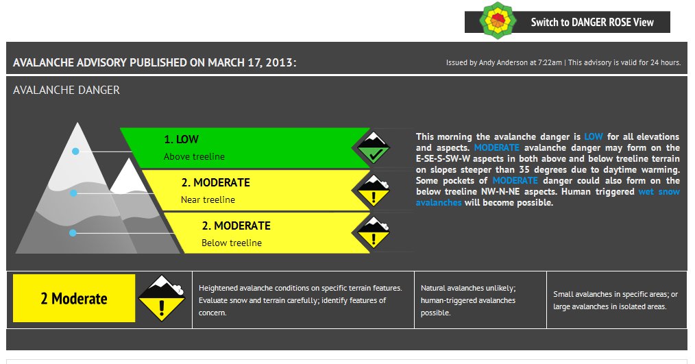
The Mountain Graphic / Basic View
This graphic provides a general overview of the avalanche danger with a short paragraph on the "Bottom Line" information. This section many tell you whether you can safely walk you dog on a mountain trail or snowmobile on a mountain road. The rest of the advisory gives more specific avalanche information you will need for more specific trip planning decisions. For a tutorial on danger ratings click HERE.
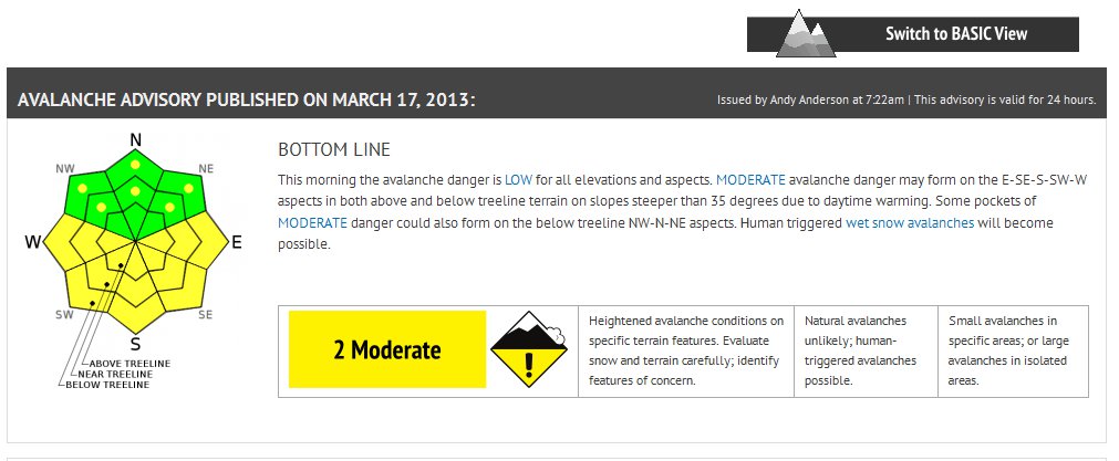
The Danger Rose View:
This view provides the same "bottom line" summary paragraph as the mountain/basic view. The danger rose graphic next to the bottom line displays the danger rating by aspect and elevation.
Imagine looking straight down on a mountain from above where the center of the diagram is the top of the mountain and the outside edges of the diagram are the lowest elevation terrain. The shape of the diagram is supposed to remind you that mountains have many ridges, gullies and bowls. For instance, even on the south side of a mountain, the sides of gullies or ridges may face east or west and there may be parts of a bowl that actually face north. Aspect is aspect no matter where you find it.
Below this Bottom Line section you will find a brief Weather section followed by a summary of the recent snow and avalanche observations. In the Recent Observations section we have included an image slider that displays the videos, photos, and snowpits collected in the last 5 days.
 |
Avalanche Problems There are many different kinds of avalanches and each has its own characteristics. Most Level 1 avalanche classes cover these various avalanche problems. For a quick tutorial, click HERE. For each problem, we tell you both graphically and in text, where you will find the problem by aspect and elevation, the characteristics of the problem including how easy it is to trigger, its size and distribution, and whether or not its is becoming more or less dangerous. |
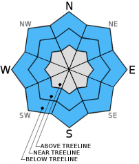 |
The Aspect-Elevation Rose The aspect-elevation rose is a powerful way to understand the general avalanche pattern in a glance by aspect (the direction a slope faces) and elevation. These blue-and-grey roses are what we call "locator roses" meaning that they show you the general aspect and elevation where you will MOST LIKELY find the avalanche problem, not all the places where you might find it. The blue areas indicate where this avalanche problem likely exists and the grey areas indicate where it likely is absent. |
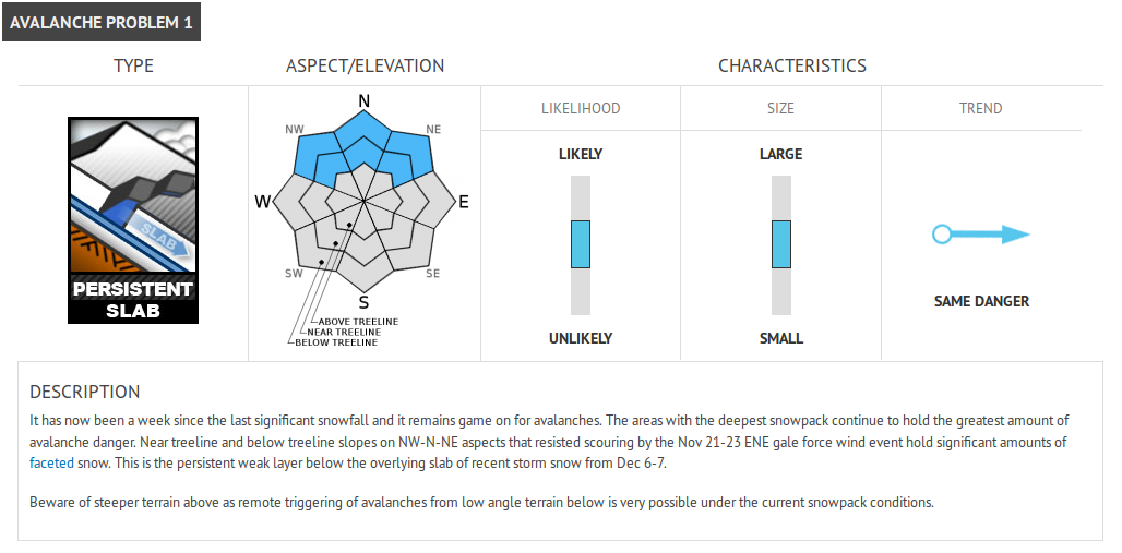
Likelihood of Triggering means the probability that a single person will trigger that type of avalanche in the terrain specified. The bottom position means it's unlikely to trigger an avalanche, the middle position means that it is possible and the top position means it's likely.
Size means the size of the avalanche. The bottom position means generally small avalanches that are fairly "manageable". The middle position means medium-sized avalanches that could easily bury a person. The top position means large, probably un-survivable avalanches.
Trend means the expected future trend of the avalanche danger, getting safer, staying the same or getting more dangerous. When the arrow slants up the danger is increasing. When it slants down, the danger is decreasing. When it is horizontal, the danger is staying the same.
Finally, remember this information is only for AVALANCHE TERRAIN, which is generally slopes steeper than 30 degrees (or flatter slopes locally connected to steeper terrain). Even on high danger days you can find much safer terrain if you stay on slopes less steep than about 30 degrees that are not underneath steeper terrain.

