

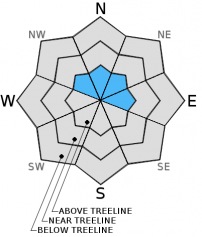
You are here
Avalanche Advisory for 2014-01-05 07:19:11
- EXPIRED ON January 6, 2014 @ 7:19 amPublished on January 5, 2014 @ 7:19 am
- Issued by -
Bottom Line
All areas, other than Mt. Shasta's glaciers, do not have enough snow to warrant an avalanche danger rating.
The avalanche danger on the glaciers is LOW. Open bergshrunds/crevasses, potentially weak snow bridges and large ice patches will be encountered on most of the glaciers. Self-arrest will be difficult with the current conditions. Rock fall is ever present on the mountain and potentially life-threatening. Climbing select routes on Mt. Shasta is not recommended at this time, though hiking on the lower elevation flanks can still be enjoyable. If you still choose to climb, please read the Climbing Advisory.
Have a great day!


Avalanche Problem 1: Normal Caution
-
Character ?

-
Aspect/Elevation ?
-
Likelihood ?CertainVery LikelyLikelyPossible
 Unlikely
 -
Size ?HistoricVery LargeLargeSmall

The avalanche danger on Mt Shasta's glaciers is LOW. Skiing on the glaciers at this time is rough and icy. Any skiing on the north or east side glaciers would be not for the faint of heart! Be cautious of open bergshrunds, crevasses, ice patches, and rock/ice fall. Self arrest may be difficult with current conditions. Always keep an eye and ear above for rock fall.
Recent Observations
A chilly but sunny day ensued yesterday as we hosted our Companion Rescue clinic at Shastice Park. We had a good turn out granted we have no snow. Bushes and leaves provided a great way to hide the beacons! Thanks to all that showed up. Our next Avalanche Awareness and Companion Rescue classes will be held February 7th and 8th. Check the education and events tab of our site for the listings and details. Coming up this month, The SNOW BALL on January 25th as well as the Shasta Ascension Backcountry Ski Race!
On New Years Day, we had a rockfall accident on the south side of Mt Shasta on the Avalanche Gulch (AG) route. Three climbers were attempting to climb the AG route on January 1st and were right of 'The Heart' at approximately 11,700 feet when a shower of rocks struck the climbers and knocked them off their feet. Each fell several hundred feet over rock and ice. One female suffered critical head and leg injuries though she should make a full recovery. A male climber suffered a head injury also and a broken elbow. The third climber got lucky and had cuts/contusions and abraisions only. Both the critical female and male climbers were hoisted off the mountain with cooperation between Siskiyou County SAR, California Highway Patrol helicopter H-16 and a USFS Climbing Ranger. The climbers had little to no experience and did not have ice axes or crampons. They did say they were wearing helmets but "they flew off" during their falls and never located. This accident is exactly why we do not recommend climbing this route when conditions are as such.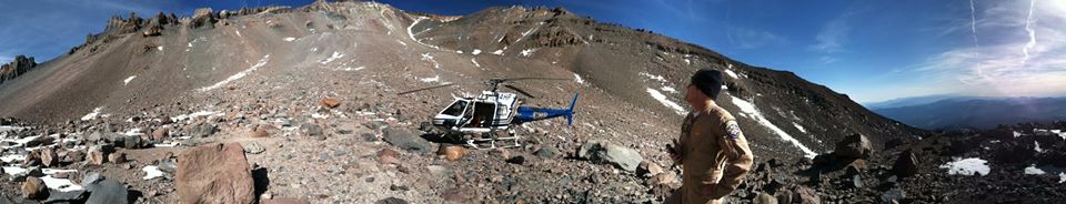
California Highway Patrol helicopter H-16 awaits Ranger N. Meyers and last member of the climbing party as they descend the Avalanche Gulch route on New Years Day. [Photo: John Scala]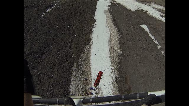
The first hoist of the critical female climber; Meyers and two other climbers below. Jan 1st, 2014. [Photo: J. Scala]
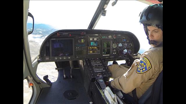
Pilot Steve Weyand at the helm. [Photo: K. Alexander]
Mt Shasta has received no new snow over the past week (surprise, surprise!) and conditions continue to be the same: partly cloudy to mostly sunny and mild. Recreation has been in the form of ice skating, mountain biking, hiking, ice fishing and anthing else not on snow. Most upper elevation lakes are frozen and pretty good for ice skating, but always use caution as conditions change daily.
Downright desperate snow conditions only a couple inches deep at best can be found above 6,500 feet on shaded, northerly slopes. Other aspects are devoid of snow. Northerly/shaded slopes holding the most snow consist of sugary, faceted snow with various near surface crusts. That being said, much of these crust layers and snow in general has melted in recent weeks and we are basically starting over with our snowpack. We have such little snow on the ground now that it will likely not affect the future avalanche danger until we get measurable snow.
Beyond the gate at Bunny Flat and the Sand Flat Winter Trails, snow is gone right now and skiing is not possible until we get more snow. For the most hard up skiers, Shasta's glaciers are the only skiing to be had in the area.
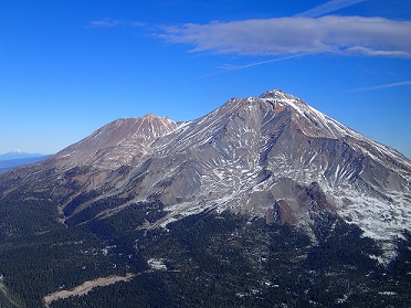
Aerial photo of the South side of Mt. Shasta, taken 12-18-13. (Photo: H Meyers)
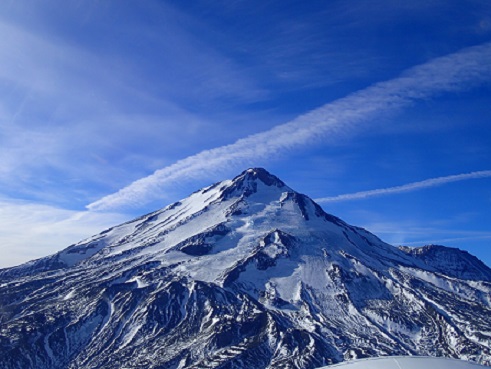
The North Side of Mt. Shasta with the Hotlam Glacier in center, Hotlam/Wintun ridge left, Shastina to the far right. Taken 12-18-13. (Photo: H Meyers)
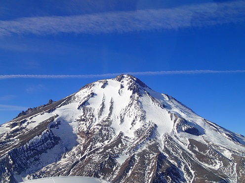
The East side of Mt. Shasta, taken 12-18-13 (Photo: H Meyers)
Terrain: Remember most of the terrain that we like to play on is greater than 30 degrees. Avalanches are possible on anything steeper than 30 degrees. Avoid cornices, rock bands, terrain traps and runout zones of avalanche paths.
Weather: Most of our areas avalanche danger will occur 24-48 hours after a storm. We still can see persistent weak layers from time to time and we always will be sure to let you know about that! Heed the basic signs: Wind (significant snow transport and depositions), Temperature (rain/snow/rain/snow, which in turn weakens the snowpack), and Precipitation (Snow or rain add weight and stress to the current snowpack).
Snowpack: If snow accumulates, give the snowpack a chance to adjust to the new snow load before you play on or near steep slopes (greater than 30 degrees). Most direct action avalanches occur within 24-48 hours of recent snowfall. Watch for obvious signs of snowpack instability such as recent natural avalanche activity, collapsing of the snowpack (often associated with a “whumphing” sound), and shooting cracks. If you see these signs of instability, limit your recreation to lower angle slopes.
Human Factor: Don’t forget to carry and know how to use avalanche rescue gear. You should NOT be skiing or climbing potential avalanche slopes without having beacons, shovels, and probes. Only one person in a group should be exposed to potential avalanche danger at a time. Remember, climbing, skiing, and riding down the edge of slopes is safer than being in the center. Just because another person is on a slope doesn’t mean that it is safe. Be an individual! Make your own decisions. Heed the signs of instability: rapid warming, “whumphing” noises, shooting cracks, snowing an inch an hour or more, rain, roller balls, wind loading, recent avalanche activity.
Weather and Current Conditions
Weather Summary
In Mt Shasta City this morning at 0500, we have clear skies once again, with a brisk current temperature of 19F degrees.
On Mt Shasta (South Side) in the last 24 hours...
Old Ski Bowl - 7,600 feet, we have no new snow, with a snow depth total 0-2 inches in shaded and/or northerly facing aspects. The current temperature is 35F with a low of 31F and a high of 45F.
Gray Butte - 8,000 feet, the current temperature is 39F. Temps have ranged from a low of 32F to a high 39F. Winds averaged 20-30 mph from northeast/east for the last 24 hours with a max gust to 56mph, straight east, at 0800 yesterday. Wind speeds have fallen a bit this morning though still averaging about 20mph with gusts into the mid-thirties.
Castle Lake and Mt Eddy (West side of I-5)...
Castle Lake - 5,600 feet, the current temperature is 33F with a low of 26F and a high of 41F. Castle Lake has no new snow with a current snowpack of 0-2 inches in more shaded areas and/or northerly aspects.
Mt Eddy - 6,500 feet, the current temperature is 33F with a low of 31F and a high of 45F. Winds have averaged 2 mph with gusts to 12 mph and southwest in nature. Snow depth total is 0-2 inches.
THIS SEASON: We'll reset the numbers and see where we stand this year, 2014. While it's quite early still, thus far, since September 1st (the wet season), we have received 2.82 inches of water, normal is 16.82 inches, putting us at 16% of normal. For the month of January, Mt Shasta has received 0.00 inches of water with normal being .94 inches. For the year 2014, Mt Shasta has received 0.00 inches of water, normal is .94 inches.
Mt Shasta finished off 2013 with exactly 10.00 inches of water, normal is 43.21", putting us at a meager 23% of normal. Let it be known that a DESERT is classified as an area that receives 10 inches of water or less per year. Welcome to the Mt. Shasta area desert biome.
December 2012 was wetter than the entire 2013 calendar year (10.43"). WOW!
WEATHER SYNOPSIS:
I hope you can take one more day of sunny and clear skies. It's tough, I know. We are approaching somewhat of a change as the coming week draws near. Monday should be somewhat of a transition day. Tuesday we should begin to see a series of systems move through the Mt. Shasta area. Initial precip amounts look to be around .10 of an inch of water, which could mean a couple inches of snow on the mountain. Past Tuesday, we'll see a chance of rain and snow for the rest of the week, but nothing to write home about.
The Earth reached its perihelion yesterday morning, the 4th of January. This is the point in a planets orbit that is closest to the sun. Brilliant Jupiter rises as dusk and remains out all night and is the brightest and largest of the year today. It will remain out all night in January and most of the night throughout the winter. The Quadrantid meteor showers reached their maximum yesterday, but still may be visible at night to the North with 25 meteor's per hour.
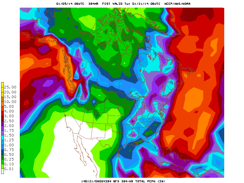
Image below shows total precipitation amounts to fall through January 21st. As you can see, the Mt. Shasta area sits at .25 to .5 at best. Hopefully this will change!
| 0600 temperature: | 35 |
| Max. temperature in the last 24 hours: | 45 |
| Average wind direction during the last 24 hours: | ENE |
| Average wind speed during the last 24 hours: | 20-30 mi/hr |
| Maximum wind gust in the last 24 hours: | 56 mi/hr |
| New snowfall in the last 24 hours: | 0 inches |
| Total snow depth: | 0-2 inches |
Two Day Mountain Weather Forecast
Produced in partnership with the Medford NWS
| For 7000 ft to 9000 ft | |||
|---|---|---|---|
|
Sunday (4 a.m. to 10 p.m.) |
Sunday Night (10 p.m. to 4 a.m.) |
Monday (4 a.m. to 10 p.m.) |
|
| Weather | Sunny | Clear | Partly sunny |
| Temperature (°F) | 47 | 28 | 44 |
| Wind (mi/hr) | East/southest 5-10mph | East/southeast 5-10mph | South 5-10mph5-10mph |
| Precipitation SWE / Snowfall (in) | / 0 | / 0 | / 0 |
| For 9000 ft to 11000 ft | |||
| Sunday | Sunday Night | Monday | |
| Weather | Sunny | Clear | Partly sunny |
| Temperature (°F) | 45 | 28 | 41 |
| Wind (mi/hr) | North, becoming southeast in the afternoon 10-20mph gusting to 30mph | South 0 | West/southwest 15-25mph with gusts to 40mph |
| Precipitation SWE / Snowfall (in) | / 0 | / 0 | / 0 |

