

You are here
Avalanche Advisory for 2014-02-09 07:12:31
- EXPIRED ON February 10, 2014 @ 7:12 amPublished on February 9, 2014 @ 7:12 am
- Issued by Adam Teel - Mt. Shasta Avalanche Center
Bottom Line
Currently, the avalanche danger is LOW for all aspects and elevations. Be careful of shallow buried objects!
Rockfall is still a hazard on Mt. Shasta until we receive significant snow. Climbing is not recommended on select routes. Be sure to check the climbing advisory if you still choose to climb.


Avalanche Problem 1: Normal Caution
-
Character ?

-
Aspect/Elevation ?
-
Likelihood ?CertainVery LikelyLikelyPossible
 Unlikely
 -
Size ?HistoricVery LargeLargeSmall

The avalanche danger on Mt Shasta's glaciers and all other areas hosting snow is LOW. Normal caution advised. Be cautious of open bergshrunds, crevasses, ice patches, and rock/ice fall. Self arrest may be difficult with current conditions. Always keep an eye and ear out for rock fall.
Other areas are working on becoming covered in snow! If you choose to ski, be careful of shallow buried objects. If you find yourself climbing or skiing one of the many skinny, snow-filled gullies...keep in mind that these gullies can host much more rockfall than open slopes as they act like a funnel for any loose rocks descending the mountain. IF you choose to climb, WEAR A HELMET PROPERLY - That is, fit snugly to your head with the front of the helmet directly over your eyebrow line. Further, know how to use your ice axe and crampons!
Recent Observations
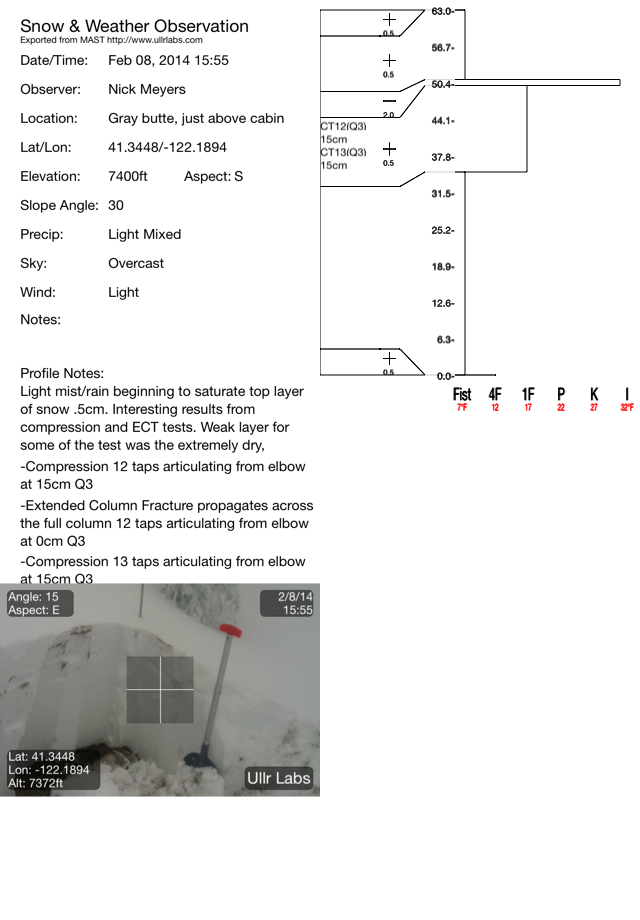
Skiing is now an option on Mt Shasta. Yesterday we had up to 12-18 inches, give or take, to play on from 6,500 feet and above. The snow came in heavy which provided decent coverage for the amounts. View the snowpit below dug up at 7,400 feet on Gray Butte. Interesting results came from this location. On a couple tests, weak layers proved to be the extremely dry, hydrophobic dirt layer at the bottom of the snowpack! The other weak layer was at 15cm and due to a density change in the snow. A pervasive ice crust was found in many areas up to 13cm below the surface. Even though stability tests gave moderate results, I feel like the overall avalanche danger is still low due to low snow depth totals and anchoring from bushes, rocks, trees, etc. I will be curious however to see how these layers develop over the next few days and weeks as we get more snow.
Rain runnels began to form below 6,500 feet yesterday beginning at about 1530. A light mist/rain fell all the way up to about 8,000 feet for portions of the afternoon creating wet snow and beginning to saturate the top layers of the snowpack. While this snow is not great for skiing, it's classic Cascade cement and will function as a great base for the rest of our season.
As always when our snowpack is shallow, watch out for objects that can cause injury near the surface of the snow.
---------------------------------------------------------------------------------------------------------------------------------------------------------------
Some trailheads are still accessible by 4 x 4 vehicle. Be cautious of any overnight trips on the mountain with snow involved. Storms can easily dump large amounts of snow to the area and make it difficult to drive off the mountain! While Northgate, Brewer Ck and Clear Ck trailheads are officially closed, the bathrooms are still open with packout bags inside, and one can still access the Mt Shasta Wilderness. However, your summit pass and wilderness permits must be purchased at McCloud or Mt Shasta Ranger Stations. NO DOGS are allowed in the Mt Shasta Wilderness OR Sierra Club Property. Thanks!
---------------------------------------------------------------------------------------------------------------------------------------------------------------
Terrain: Remember most of the terrain that we like to play on is greater than 30 degrees. Avalanches are possible on anything steeper than 30 degrees. Avoid cornices, rock bands, terrain traps and runout zones of avalanche paths.
Weather: Most of our areas avalanche danger will occur 24-48 hours after a storm. We still can see persistent weak layers from time to time and we always will be sure to let you know about that! Heed the basic signs: Wind (significant snow transport and depositions), Temperature (rain/snow/rain/snow, which in turn weakens the snowpack), and Precipitation (Snow or rain add weight and stress to the current snowpack).
Snowpack: If snow accumulates, give the snowpack a chance to adjust to the new snow load before you play on or near steep slopes (greater than 30 degrees). Most direct action avalanches occur within 24-48 hours of recent snowfall. Watch for obvious signs of snowpack instability such as recent natural avalanche activity, collapsing of the snowpack (often associated with a “whumphing” sound), and shooting cracks. If you see these signs of instability, limit your recreation to lower angle slopes.
Human Factor: Don’t forget to carry and know how to use avalanche rescue gear. You should NOT be skiing or climbing potential avalanche slopes without having beacons, shovels, and probes. Only one person in a group should be exposed to potential avalanche danger at a time. Remember, climbing, skiing, and riding down the edge of slopes is safer than being in the center. Just because another person is on a slope doesn’t mean that it is safe. Be an individual! Make your own decisions. Heed the signs of instability: rapid warming, “whumphing” noises, shooting cracks, snowing an inch an hour or more, rain, roller balls, wind loading, recent avalanche activity.
Weather and Current Conditions
Weather Summary
In Mt Shasta City this morning at 0500, we have overcast skies and a current temperature of 42 F.
On Mt Shasta (South Side) in the last 24 hours...
Old Ski Bowl - 7,600 feet, we've had 2-4 inches new snow over the last 24 hours. Our current snow depth total at the Old Ski Bowl is 12-15 inches! The current temperature is 27F with a low of 26F and a high of 30F.
Gray Butte - 8,000 feet, the current temperature is 27F. Temps have ranged from a low of 26F to a high 29F. The anemometer at this station has been riming up and frozen but recorded winds between 1500 and 1900 averaging 15 mph from the WNW with a gust to 35mph, WNW also. We are working on resolving the riming problem!
Castle Lake and Mt Eddy (West side of I-5)...
Castle Lake - 5,600 feet, the current temperature is 33F with a low of 31F and a high of 34F. Castle Lake has received 2 inches of new snow with a current snowpack of 6 inches.
Mt Eddy - 6,500 feet, the current temperature is 32F with a low of 29F and a high of 35F. Mt Eddy has 6 inches new snow and a current snow depth total of 10 inches. Winds have averaged 2 mph with gusts to 12 mph, southwest in nature.
THIS SEASON: Since September 1st (the wet season), we have received 4.01 inches of water, normal is 24.89 inches, putting us at 13% of normal. For the year of 2014, Mt Shasta has received 1.19 inches of water with normal being 9.01 inches which puts us at 16% of normal. And lastly, for February we are 50% of normal, receiving 0.98 inches of water, normal is 1.95 inches.
Mt Shasta finished off 2013 with exactly 10.00 inches of water, normal is 43.21", putting us at 23% of normal. A DESERT is classified as an area that receives 10 inches of water or less per year. Yikes! ![]()
December 2012 had more precipitation than the entire 2013 calendar year (10.43"). WOW!
WEATHER SYNOPSIS:
Rain and snow. Snow accumulations of 2 to 3 inches with the freezing level around 5,500 to 6,500 ft. We will have light precipitation today and tonight with clouds remaining Monday morning and becoming partly cloudy in the afternoon. A 50% chance of more precip exists on Tuesday. We have a southerly flow showing up early to middle of next week and models are showing an 'active pattern' through late next week. We can expect a shortwave pulse of snow on Wednesday with snow levels remaining high at or above 6000 ft.
| 0600 temperature: | 27 |
| Max. temperature in the last 24 hours: | 31 |
| Average wind direction during the last 24 hours: | WNW |
| Average wind speed during the last 24 hours: | 15 mi/hr |
| Maximum wind gust in the last 24 hours: | unknown mi/hr |
| New snowfall in the last 24 hours: | 2-4 inches |
| Total snow depth: | 15 inches |
Two Day Mountain Weather Forecast
Produced in partnership with the Medford NWS
| For 7000 ft to 9000 ft | |||
|---|---|---|---|
|
Sunday (4 a.m. to 10 p.m.) |
Sunday Night (10 p.m. to 4 a.m.) |
Monday (4 a.m. to 10 p.m.) |
|
| Weather | Snow | Snow | Mostly sunny |
| Temperature (°F) | 37 | 30 | 39 |
| Wind (mi/hr) | West southwest 10-20mph, gusts to 30mph | Southwest 10-15mph | West southwest 10-15mph |
| Precipitation SWE / Snowfall (in) | / 2-4 | / 1-2 | / trace |
| For 9000 ft to 11000 ft | |||
| Sunday | Sunday Night | Monday | |
| Weather | Snow | Snow | Partly sunny |
| Temperature (°F) | 31 | 20 | 29 |
| Wind (mi/hr) | West 25-35mph with gusts higher, decreasing. | West 2-4 | West 35-45mph with gusts higher |
| Precipitation SWE / Snowfall (in) | / 2-4 | / 1-2 | / trace |

