

You are here
Avalanche Advisory for 2014-02-23 07:22:59
- EXPIRED ON February 24, 2014 @ 7:22 amPublished on February 23, 2014 @ 7:22 am
- Issued by -
Bottom Line
The avalanche danger is LOW for all aspects and elevations. Caution is advised if you find yourself on shady, northerly slopes >35 degrees hosting isolated wind/hard slabs on top of existing snow.
Climbers: ROCK & RIME ICE FALL will be a hazard this weekend. The snowpack is still shallow (1-3 feet) and a slip and fall on hard, firm snow without self arrest skills will likely prove disastrous.
Be sure to check the climbing advisory if you still choose to climb.


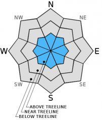
Avalanche Problem 1: Wind Slab
-
Character ?

-
Aspect/Elevation ?
-
Likelihood ?CertainVery LikelyLikelyPossible
 Unlikely
 -
Size ?HistoricVery LargeLargeSmall

Mt Shasta has received .07 inches of water during this past weeks "storm", resulting in a couple inches of new snow above 6,900 feet on Shasta. Northwest winds blew for most of the week and peaked on Wednesday morning with gusts to 80mph. Much of our old snow is rock solid and wind scoured. However, leeward slopes, gullies, depressions, and lower lying areas (above treeline) host a mix of wind packed powder and harder wind slabs. Yesterday, small wind slabs dotted the landscape above treeline. One should use caution when on wind slabs sitting on firm, old snow on steeper slopes (>35 degrees). Wind slabs will be small in size with isolated distribution. Triggering of said wind slabs is very unlikely, though not impossible.
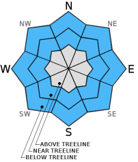
Avalanche Problem 2: Normal Caution
-
Character ?

-
Aspect/Elevation ?
-
Likelihood ?CertainVery LikelyLikelyPossible
Unlikely
-
Size ?HistoricVery LargeLargeSmall
The snowpack on Mt Shasta is firm! Northwest winds have beat the mountain over this past week and scoured much of our snowpack down to ice and hard snow. While these hard, firm areas host low avalanche danger, a slip and fall on hard, smooth snow without self-arrest skills could result in a long fall over snow and rock. If climbing this weekend, please be careful.
Southerly facing, sun affected slopes are moving into melt/freeze cycles and yesterday hosted some decent "corn" skiing in Powder Bowl.
Recent Observations
Overall, it's a mix between hard, firm conditions, isolated wind slabs and pockets of powder. Southerly, sun affected slopes with decent coverage are moving toward melt/freeze and some decent corn skiing was found in Powder Bowl yesterday, mid afternoon. Powder Bowl is south facing and gets very good sun and is protected from northwest winds.
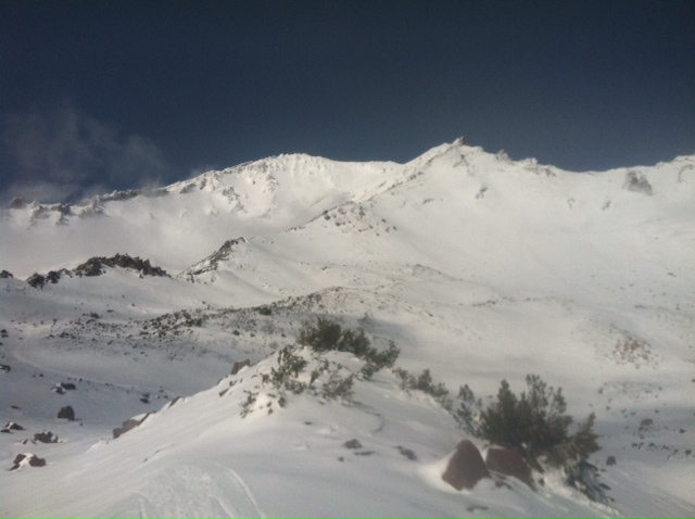
A look up into the Old Ski Bowl, with Casaval Ridge and the Trinity Chutes in background, and Green Butte Ridge slicing left to right up to Sargents Ridge. [Photo: 2-21-14 N Meyers]
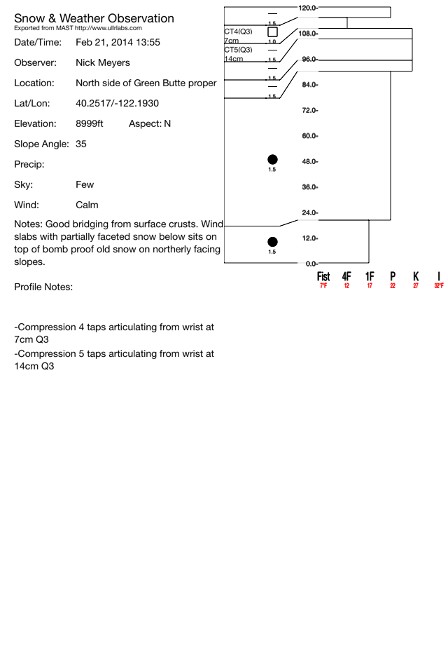
Northerly facing, cooler slopes are variable and host poor skiing. The old snow from weeks past is completely bombproof and difficult to penetrate with shovel, boot and even probe. Some areas of old snow has an icy sheen to it and is very, very slick. For climbers, a slip and fall on this smooth, icy snow could prove disastrous as self arrest would be difficult as many rocks still stick out of the snow like jagged teeth. The wind slabs we found were 10 to 30 cm thick. About the bottom 2/3 of any given wind slab hosted partial faceting and in general, sugary snow sitting on the firm, old snow. The top 1/3 of the slab hosted sun/wind crusts 5 to 10 cm thick. While compression tests scores were low, bridging from crusts and only partially developed facets are keeping things intact at this point and full slab propagation is not likely with the current conditions. Our weather leading up to next weeks storms will dictate the development of these weak layers. We have potentially two up coming avalanche problems: new snow on top of wind slabs with underlying weak layers, and/or new snow on top of icy, old snow. At this point, triggering any avalanche activity will be difficult. Overall, our pit was 120cm deep on the north facing aspect of Green Butte, one of the deepest areas we could find.
For now, snow conditions are still slim and shallow! Any recent pictures you might have seen of Shasta make it look like conditions are pretty good. I suppose it IS good considering our winter, however in reality, there is only about 1-3 feet of snow on the mountain. Many of the rocks are white and look covered, but this is rime ice and not snow. Anybody wishing to climb this weekend is cautioned: rock and rime ice fall will be a hazard, especially during the warmest portions of the day. A slip and fall on any existing frim and icy snow, as mentioned above, will likely prove disastrous if unable to self arrest.
Snow is melting and patchy below 6,000 feet and many shallow buried object exists below treeline.
---------------------------------------------------------------------------------------------------------------------------------------------------------------
Some trailheads are still accessible by 4 x 4 vehicle. Be cautious of any overnight trips on the mountain with snow involved. Storms can easily dump large amounts of snow to the area and make it difficult to drive off the mountain! While Northgate, Brewer Ck and Clear Ck trailheads are officially closed, the bathrooms are still open with packout bags inside, and one can still access the Mt Shasta Wilderness. However, your summit pass and wilderness permits must be purchased at McCloud or Mt Shasta Ranger Stations. NO DOGS are allowed in the Mt Shasta Wilderness OR Sierra Club Property. Thanks!
---------------------------------------------------------------------------------------------------------------------------------------------------------------
Terrain: Remember most of the terrain that we like to play on is greater than 30 degrees. Avalanches are possible on anything steeper than 30 degrees. Avoid cornices, rock bands, terrain traps and runout zones of avalanche paths.
Weather: Most of our areas avalanche danger will occur 24-48 hours after a storm. We still can see persistent weak layers from time to time and we always will be sure to let you know about that! Heed the basic signs: Wind (significant snow transport and depositions), Temperature (rain/snow/rain/snow, which in turn weakens the snowpack), and Precipitation (Snow or rain add weight and stress to the current snowpack).
Snowpack: If snow accumulates, give the snowpack a chance to adjust to the new snow load before you play on or near steep slopes (greater than 30 degrees). Most direct action avalanches occur within 24-48 hours of recent snowfall. Watch for obvious signs of snowpack instability such as recent natural avalanche activity, collapsing of the snowpack (often associated with a “whumphing” sound), and shooting cracks. If you see these signs of instability, limit your recreation to lower angle slopes.
Human Factor: Don’t forget to carry and know how to use avalanche rescue gear. You should NOT be skiing or climbing potential avalanche slopes without having beacons, shovels, and probes. Only one person in a group should be exposed to potential avalanche danger at a time. Remember, climbing, skiing, and riding down the edge of slopes is safer than being in the center. Just because another person is on a slope doesn’t mean that it is safe. Be an individual! Make your own decisions. Heed the signs of instability: rapid warming, “whumphing” noises, shooting cracks, snowing an inch an hour or more, rain, roller balls, wind loading, recent avalanche activity.
Weather and Current Conditions
Weather Summary
In Mt Shasta City this morning at 0500, we have clear skies with a current temperature is 31 F.
On Mt Shasta (South Side) in the last 24 hours...
Old Ski Bowl - 7,600 feet. Shasta has received no new snow in the last 24 hours. Our current snow depth total at the Old Ski Bowl is 27 inches. The current temperature is 35F with a low of 29F and a high of 44F.
Gray Butte - 8,000 feet - The current temperature is 35F. Temps have ranged from a low of 31F to a high 44F. Winds have averaged 12 mph from the WNW with gusts to 28 mph from the NW this morning at 0400.
Castle Lake and Mt Eddy (West side of I-5)...
Castle Lake - 5,600 feet, the current temperature is 38F with a low of 31F and a high of 46F. Castle Lake has received no new snow and a current snowpack of 2-4 inches.
Mt Eddy - 6,500 feet, the current temperature is 31F with a low of 30F and a high of 43F. Mt Eddy has no new snow and a current snow depth total of 7 inches. Winds have averaged 3 mph with gusts to 7 mph, southerly in nature.
THIS SEASON: Since September 1st (the wet season), we have received 6.39 inches of water, normal is 28.54 inches, putting us at 22% of normal. For the year of 2014, Mt Shasta has received 3.57 inches of water with normal being 12.66 inches which puts us at 28% of normal. And lastly, for February we are 60% of normal, receiving 3.36 inches of water, normal is 5.60 inches.
WEATHER SYNOPSIS:
Another warm and sunny day today. The overnight low temps were slightly higher last night and today we can expect the daytime high to be a few degrees warmer than yesterday. Light winds today coming out of the West moving more Southwest as the day progress's. Tonight we have a 20-30 percent chance of some light precip ahead of the clouds moving in for Monday. Snow and rain are on their way starting as early as Wednesday and gaining strength through the weekend. The freezing level is expected to drop down below bunny flat elevation on Tuesday so we should be seeing some of that rare white stuff we like to play on.
| 0600 temperature: | 28 |
| Max. temperature in the last 24 hours: | 43 |
| Average wind direction during the last 24 hours: | Westerly |
| Average wind speed during the last 24 hours: | 7 mi/hr |
| Maximum wind gust in the last 24 hours: | 23 mi/hr |
| New snowfall in the last 24 hours: | 0 inches |
| Total snow depth: | 28 inches |
Two Day Mountain Weather Forecast
Produced in partnership with the Medford NWS
| For 7000 ft to 9000 ft | |||
|---|---|---|---|
|
Sunday (4 a.m. to 10 p.m.) |
Sunday Night (10 p.m. to 4 a.m.) |
Monday (4 a.m. to 10 p.m.) |
|
| Weather | Sunny | cloudy | Mostly cloudy with a chance of precipitation in the morning. Little to no snow accumulation expected. |
| Temperature (°F) | 46 | 29 | 46 |
| Wind (mi/hr) | West 5-10mph | West 5-10mph | South/Southwest 5-10mph |
| Precipitation SWE / Snowfall (in) | / 0 | / 0 | / 0 |
| For 9000 ft to 11000 ft | |||
| Sunday | Sunday Night | Monday | |
| Weather | Sunny | Mostly cloudy | Mostly cloudy |
| Temperature (°F) | 40 | 25 | 38 |
| Wind (mi/hr) | West 15-25mph | West 0 | South 15-25mph |
| Precipitation SWE / Snowfall (in) | / 0 | / 0 | / 0 |

