

You are here
Avalanche Advisory for 2014-03-14 07:12:18
- EXPIRED ON March 15, 2014 @ 7:12 amPublished on March 14, 2014 @ 7:12 am
- Issued by Nick Meyers - Shasta-Trinity National Forest
Bottom Line
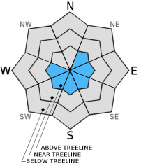
Below and near treeline areas on Mt Shasta, all aspects, the avalanche danger is LOW.
Above treeline, isolated areas may host small to medium size wind slabs with MODERATE avalanche danger on NE-E-SE-S-SW-W aspects.
Moderate avalanche danger means that natural avalanches are unlikely; human triggered avalanches are possible.


Avalanche Problem 1: Wind Slab
-
Character ?

-
Aspect/Elevation ?
-
Likelihood ?CertainVery LikelyLikelyPossible
 Unlikely
 -
Size ?HistoricVery LargeLargeSmall

While it appears that most of the new snow from last weekend has simply blown off the mountain, one should not rule out the chance of isolated pockets of wind slabs on the mountain, above treeline. Slabs could be 6 inches to several feet deep and small to medium in size. Wind slabs will be likely stubborn to trigger, however a large group or snowmobile may be enough to trigger said avalanches. I would expect wind slabs to be prevalent on many aspects as winds blew from the north/northwest on Monday and Tuesday and switched to Easterly on Wednesday. Wind slabs will be hard and hollow sounding. Use caution if you find yourself climbing or skiing on hard wind slabs as they can fracture and propagate well above your position on the slab and escape of these type of avalanches is difficult.
Recent Observations
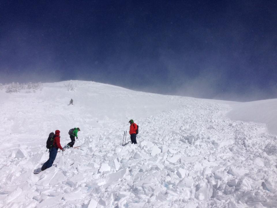
Last weekend, Mt Shasta had a just over 1 inch of water fall on its flanks with snow levels fluctuating between 6,500 to 8,000 feet. This brought new snow to the mountain and was immediately followed by two days (Monday/Tuesday) of strong northwest winds and one day (Wednesday) of strong easterly winds. The new snow and wind created good conditions for wind slab avalanche potential on many aspects. On Monday (3-10-14), the MSAC got the report of a skier triggered (ascending) wind slab avalanche in the Anaconda drainage of Mt Shasta, approx. 9,200 feet. The avalanche was approx. 400' wide and ran 250' vertical feet. (HS-ASu-R2-D2-I) 3 people caught, partially buried, no injuries. (See photos below)
Another group of backcounytry skiers report seeing evidence of wind slab avalanches (debris) in the Hidden Valley area later in the week. It is likely that the mountain saw somewhat widespread avalanche activity early in the week during the wind event. Most of the slides were small to medium in size and the debris was subsequently eroded away by the wind after slides occured.
After the wind subsided, it turns out that most of our newer snow simply blew off the mountain. The mountain is currently hosting firm, wind blown conditions with pockets of wild looking wind erosional features. The best skiing has ended up being the old snow that is beginning to turn to "corn snow" in the afternoon hours. This weekend, some southerly slopes could host good spring like skiing. For climbers, conditions are getting good on all routes. However that being said, this is the time of year when the snow is smooth and firm, especially in the AM hours. A slip and fall on smooth, firm and sometimes icy snow can result in a slide for life. Self arrest skills with an ice axe and proper crampon use are essential for a safe climb. Further, a beacon/shovel/probe are absolutely recommended for any climbers attempting Shasta currently. Lastly, while the rockfall danger is low currently, rime ice can plaster exposed rocks on Shasta this time of year. As the days warm, the rime ice will flake off and fall onto climbers below, especially on the Avalanche Gulch route. Ice is like a rock and a HELMET should always be worn.
Photos below: Skier triggered wind slab avalanche on Mt Shasta, 3-10-14
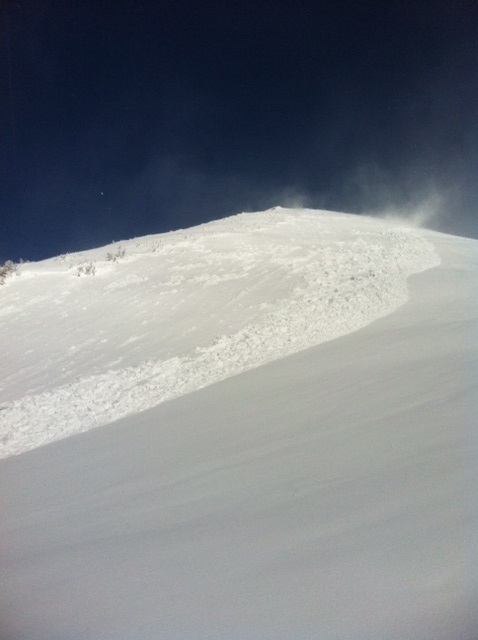
Wind erosional feature in the Old Ski Bowl, 3-12-14
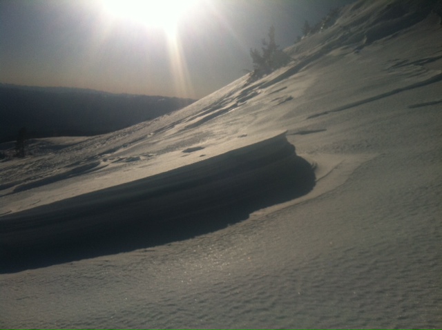
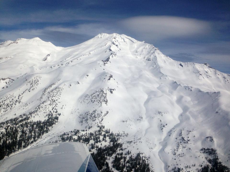
Aerial photo of the South side of Mt Shasta, taken by local pilot Troy Bainbridge just a few days ago.
---------------------------------------------------------------------------------------------------------------------------------------------------------------
While Northgate, Brewer Ck and Clear Ck trailheads are officially closed, the bathrooms are still open with packout bags inside, and one can still access the Mt Shasta Wilderness. However, your summit pass and wilderness permits must be purchased at McCloud or Mt Shasta Ranger Stations. NO DOGS are allowed in the Mt Shasta Wilderness OR Sierra Club Property. Thanks!
---------------------------------------------------------------------------------------------------------------------------------------------------------------
Terrain: Remember most of the terrain that we like to play on is greater than 30 degrees. Avalanches are possible on anything steeper than 30 degrees. Avoid cornices, rock bands, terrain traps and runout zones of avalanche paths.
Weather: Most of our areas avalanche danger will occur 24-48 hours after a storm. We still can see persistent weak layers from time to time and we always will be sure to let you know about that! Heed the basic signs: Wind (significant snow transport and depositions), Temperature (rain/snow/rain/snow, which in turn weakens the snowpack), and Precipitation (Snow or rain add weight and stress to the current snowpack).
Snowpack: If snow accumulates, give the snowpack a chance to adjust to the new snow load before you play on or near steep slopes (greater than 30 degrees). Most direct action avalanches occur within 24-48 hours of recent snowfall. Watch for obvious signs of snowpack instability such as recent natural avalanche activity, collapsing of the snowpack (often associated with a “whumphing” sound), and shooting cracks. If you see these signs of instability, limit your recreation to lower angle slopes.
Human Factor: Don’t forget to carry and know how to use avalanche rescue gear. You should NOT be skiing or climbing potential avalanche slopes without having beacons, shovels, and probes. Only one person in a group should be exposed to potential avalanche danger at a time. Remember, climbing, skiing, and riding down the edge of slopes is safer than being in the center. Just because another person is on a slope doesn’t mean that it is safe. Be an individual! Make your own decisions. Heed the signs of instability: rapid warming, “whumphing” noises, shooting cracks, snowing an inch an hour or more, rain, roller balls, wind loading, recent avalanche activity.
Weather and Current Conditions
Weather Summary
In Mt Shasta City this morning at 0500, we have obscured skies with a current temperature of 46 F.
On Mt Shasta (South Side) in the last 24 hours...
Old Ski Bowl - 7,600 feet. The Old Ski Bowl weather station has received no new snow in the last 24 hours. The current temperature is 37F with a low of 34F and a high of 50F. Total snow depth is 56 inches with 3 inches settlement since last Sunday.
Gray Butte - 8,000 feet - The current temperature is 36F. Temps have ranged from a low of 36F to a high 48F. Winds have averaged 12 mph from the NW. Gusts hit 28 mph from the NW also.
Castle Lake and Mt Eddy (West side of I-5)...
Castle Lake - 5,600 feet, the current temperature is 36F with a low of 35F and a high of 54F. Castle Lake has received no new snow and has a current snowpack of 1-3 inches with 2-3 inches settlement since last Sunday.
Mt Eddy - 6,500 feet, the current temperature is 35F with a low of 29F and a high of 48F. Mt Eddy has received no new snow and hosts a current snow depth of 19 inches. Winds have averaged 2 mph and varialbe with gusts to 9 mph from the East.
THIS SEASON: Since September 1st , we have received 11.28 inches of water, normal is 33.26 inches, putting us at 33% of normal. For the year of 2014, Mt Shasta has received 8.46 inches of water with normal being 17.38 inches which puts us at 48% of normal. And lastly, for March we sit at 78% of normal, receiving 2.42 inches of water, normal is 3.09 inches.
WEATHER SYNOPSIS:
This morning we are seeing a small frontal system pass to the north of us into the Pacific Northwest. Our area will get the tail end of this storm, simply in the form of some lingering clouds. Precipitation is not expected and the skies should generally begin to clear as the day progresses. Clear skies and mild wind speeds will host the weekend.
| 0600 temperature: | 37 |
| Max. temperature in the last 24 hours: | 50 |
| Average wind direction during the last 24 hours: | NW |
| Average wind speed during the last 24 hours: | 12 mi/hr |
| Maximum wind gust in the last 24 hours: | 28 mi/hr |
| New snowfall in the last 24 hours: | 0 inches |
| Total snow depth: | 56" inches |
Two Day Mountain Weather Forecast
Produced in partnership with the Medford NWS
| For 7000 ft to 9000 ft | |||
|---|---|---|---|
|
Friday (4 a.m. to 10 p.m.) |
Friday Night (10 p.m. to 4 a.m.) |
Saturday (4 a.m. to 10 p.m.) |
|
| Weather | Partly Sunny | Clear | Sunny |
| Temperature (°F) | 48 | 30 | 55 |
| Wind (mi/hr) | Northwest 5-15 mph | Northwest 5-15 mph | East / Northeast 5-15 mph |
| Precipitation SWE / Snowfall (in) | / 0 | / 0 | / 0 |
| For 9000 ft to 11000 ft | |||
| Friday | Friday Night | Saturday | |
| Weather | Partly Sunny | Clear | Sunny |
| Temperature (°F) | 35 | 22 | 41 |
| Wind (mi/hr) | West/Northwest 20-30 mph, with gusts higher | Northwest 0 | Northwest 20-30 mph |
| Precipitation SWE / Snowfall (in) | / 0 | / 0 | / 0 |

