

You are here
Avalanche Advisory for 2014-12-12 07:07:38
- EXPIRED ON December 13, 2014 @ 7:07 amPublished on December 12, 2014 @ 7:07 am
- Issued by Nick Meyers - Shasta-Trinity National Forest
Bottom Line
Mt Shasta has received 24" of snow over the last 24 hours and 42" in the last 48 hours. Winds have been consistently blowing Southerly in direction, 10-20mph with gusts to 49 mph.
Wind and Storm Slab avalanches are the avalanche problems for today. Backcountry travel near and above treeline on slopes steeper than 30 degrees, all aspects, is not advised. Wind loaded slopes, N-NE-E facing will host the deepest slabs and pose the largest avalanche potential.
Give runnout zones a wide berth!


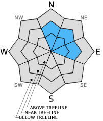
Avalanche Problem 1: Wind Slab
-
Character ?

-
Aspect/Elevation ?
-
Likelihood ?CertainVery LikelyLikelyPossible
 Unlikely
 -
Size ?HistoricVery LargeLargeSmall

Wind slab avalanches will be of greatest concern today for backcountry riders. The impressive storm that began mid-day on Wednesday the 10th has brought a storm total of 42 inches of snow at 8,000 feet (Old Ski Bowl weather station) and 24 inches of new snow in the last 24 hours.
Winds on Grey Butte blew consistently Southerly in direction over the past couple days. Wind speeds averaged 10-20 mph with gusts to 49 mph.
Slopes near and above treeline and N-NE-E facing will be heavily wind loaded and have the best potential for instability. Avalanche size could be very large, destructive and most definitely a threat to human life. Travel on slopes steeper than 30 degrees, N-NE-E facing, near and above treeline is not advised. Further, use caution while traveling on lower angle slopes that are runnout zones from slide paths higher on the mountain.
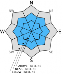
Avalanche Problem 2: Storm Slab
-
Character ?

-
Aspect/Elevation ?
-
Likelihood ?CertainVery LikelyLikelyPossible
Unlikely
-
Size ?HistoricVery LargeLargeSmall
Storm snow avalanches will be most prevalent near and above treeline on all aspects. Avoid slopes steeper than 30 degrees and let the snow settle out and stabilize for a couple days. Give runout zones a wide berth or when you notice others traveling above. Test slopes, snow pits, slope cuts, previous tracks and cornice drops tend to provide some level of information on stability.
Recent Observations
The storm gave the area a large dollup of new snow that came in "right side up". That is, heavier snow on the bottom and lighter snow on the top. We like that. However, that being said, 42" inches of snow with wind in a relative short amount of time is a red flag. Use caution today. Stick to lower angle slopes and give runout zones plenty of room.
Multiple observations from local skiers reported zero visibility above treeline yesterday. Most stuck to lower angle slopes with trees and reported good skiing on supportable powder. No signs of instabilities were mentioned (shooting cracks, whoomphs, natural avalanches), however once again visibility was limited. That being said, I'm not convinced we are in the clear.
Report your observations to the MSAC! A photo, a few words... send them in! (nimeyers@fs.fed.us or 530-926-9614)
Castle Lake area still has no snow.
Mt Eddy area is hosting about a 10" of snow. I have not been up into that area yet and have received no reports.
It's early season and most know what that means... shallow buried objects and thick, wet snow. Both these factors together make risk for injury high! Take it easy and safe yourself for when the gettin' is good!
-------------------------------------------------------------------------------------------------------------------------------
Terrain: Remember most of the terrain that we like to play on is greater than 30 degrees. Avalanches are possible on anything steeper than 30 degrees. Avoid cornices, rock bands, terrain traps and runout zones of avalanche paths.
Weather: Most of our areas avalanche danger will occur 24-48 hours after a storm. We still can see persistent weak layers from time to time and we always will be sure to let you know about that! Heed the basic signs: Wind (significant snow transport and depositions), Temperature (rain/snow/rain/snow, which in turn weakens the snowpack), and Precipitation (Snow or rain add weight and stress to the current snowpack).
Snowpack: If snow accumulates, give the snowpack a chance to adjust to the new snow load before you play on or near steep slopes (greater than 30 degrees). Most direct action avalanches occur within 24-48 hours of recent snowfall. Watch for obvious signs of snowpack instability such as recent natural avalanche activity, collapsing of the snowpack (often associated with a “whumphing” sound), and shooting cracks. If you see these signs of instability, limit your recreation to lower angle slopes.
Human Factor: Don’t forget to carry and know how to use avalanche rescue gear. You should NOT be skiing or climbing potential avalanche slopes without having beacons, shovels, and probes. Only one person in a group should be exposed to potential avalanche danger at a time. Remember, climbing, skiing, and riding down the edge of slopes is safer than being in the center. Just because another person is on a slope doesn’t mean that it is safe. Be an individual! Make your own decisions. Heed the signs of instability: rapid warming, “whumphing” noises, shooting cracks, snowing an inch an hour or more, rain, roller balls, wind loading, recent avalanche activity.
The Five Red Flags of Avalanche Danger any time of year include: 1) Recent/current avalanche activity 2) Whumpfing sounds or shooting cracks 3) Recent/current heavy snowfall 4) Strong winds transporting snow 5) Rapid warming or rain on snow.
Weather and Current Conditions
Weather Summary
In Mt Shasta City this morning at 0500, we have obscured skies with low lying fog and a current temperature of 37 F.
WEATHER STATION INFORMATION:
On Mt Shasta (South Side) in the last 24 hours...
Old Ski Bowl - 7,600 feet, we have a current temperature of 23 F. Snow on the ground totals 69 inches with no settlement and 24 inches of new snow in the last 24 hours. Storm total since 12/10/14 (Wednesday) is 42 inches. Temperatures have ranged from 23 F to 31 F.
Gray Butte - 8,000 feet, winds have averaged 15mph from the South and switching to N-NW early this morning, with gusts to 49 mph from the South/Southeast. The current temperature is 23 F and temps have ranged from 23 F to 31 F in the last 24 hours.
Castle Lake and Mt Eddy (West side of Interstate-5)...
Castle Lake - 5,600 feet, the current temperature is 33 F. Temps have ranged from 31 F to 36 F in the last 24 hours. Castle has no snow on the ground yet.
Mt Eddy - 6,500 feet, the current temperature is 28 F. Temps have ranged from 28 F to 32 F in the last 24 hours. Current snow depth is unknown at this time. As of last Sunday (12/7/14), 10 inches of snow was on the ground. Winds have averaged 2-4 mph out of the Southwest with gusts to 14 mph, Southwest.
WEATHER SYNOPSIS: Today we will have lingering snow showers...another 1-3 inches possible. An incoming cold front has already entered the area and will drop temperatures and snow levels down to as low as 5,000 feet. Winds will be light and variable. Tomorrow should be mostly clear as a brief high pressure ridge moves through. Enjoy the new snow and be careful.
THIS SEASON: Since September 1st , we have received 18.82 inches of water, normal is 10.60 inches, putting us at 177% of normal. For the year of 2014, Mt Shasta has received 31.10 inches of water with normal being 37.93 inches which puts us at 81% of normal. And lastly, for December we sit at 372% of normal, receiving 9.57 inches of water, normal is 2.57 inches.
Always check the weather before you attempt to climb Mt Shasta. Further, monitor the weather as you climb. Becoming caught on the mountain in any type of weather can compromise life and limb. Be prepared.
| 0600 temperature: | 23 |
| Max. temperature in the last 24 hours: | 31 |
| Average wind direction during the last 24 hours: | South to Northwest |
| Average wind speed during the last 24 hours: | 15 mi/hr |
| Maximum wind gust in the last 24 hours: | 49 mi/hr |
| New snowfall in the last 24 hours: | 24" inches |
| Total snow depth: | 69" inches |
Two Day Mountain Weather Forecast
Produced in partnership with the Medford NWS
| For 7000 ft to 9000 ft | |||
|---|---|---|---|
|
Friday (4 a.m. to 10 p.m.) |
Friday Night (10 p.m. to 4 a.m.) |
Saturday (4 a.m. to 10 p.m.) |
|
| Weather | Snow showers | Snow showers likely early in the night, otherwise mostly cloudy | Mostly Sunny |
| Temperature (°F) | 29 | 26 | 34 |
| Wind (mi/hr) | Southwest 5-10 mph | West 5-10 mph | Northeast 0-5 mph |
| Precipitation SWE / Snowfall (in) | / 1"- 3" | / 0 - 1" | / 0 |
| For 9000 ft to 11000 ft | |||
| Friday | Friday Night | Saturday | |
| Weather | Snow showers | Snow showers, early in the night, otherwise mostly cloudy | Mostly sunny |
| Temperature (°F) | 30 | 16 | 24 |
| Wind (mi/hr) | Northwest 5-15 mph | Northwest 2" - 4" | West/Northwest 15-20 mph with gusts possible to 30 mph |
| Precipitation SWE / Snowfall (in) | / 2" - 4" | / 0 - 1" | / 0 |

