

You are here
Avalanche Advisory for 2014-12-13 06:59:48
- EXPIRED ON December 14, 2014 @ 6:59 amPublished on December 13, 2014 @ 6:59 am
- Issued by Nick Meyers - Shasta-Trinity National Forest
Bottom Line
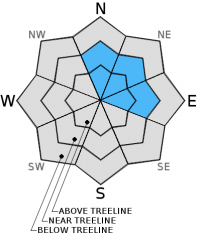
Today, CONSIDERABLE avalanche danger (human triggered avalanches likely) will continue on wind loaded, N-NE-E aspects steeper than 32 degrees above treeline.
On all other aspects near and above treeline, MODERATE avalanche danger (human triggered avalanches possible) will exist for wind and storm slabs.
Blue skies, fresh, untracked powder, the weekend... Don't let these factors cloud good judgement. Give runout zones a wide berth. Come home alive today.


Avalanche Problem 1: Wind Slab
-
Character ?

-
Aspect/Elevation ?
-
Likelihood ?CertainVery LikelyLikelyPossible
 Unlikely
 -
Size ?HistoricVery LargeLargeSmall

Wind slab avalanches will be of greatest concern today for backcountry riders. The impressive storm that began mid-day on Wednesday the 10th has brought a storm total of 42 inches of snow at 8,000 feet (Old Ski Bowl weather station) and 24 inches of new snow in the last 24 hours.
Winds on Grey Butte blew consistently Southerly in direction over the past couple days. Wind speeds averaged 10-20 mph with gusts to 49 mph.
Slopes near and above treeline and N-NE-E facing will be heavily wind loaded and have the best potential for instability. Avalanche size could be very large, destructive and most definitely a threat to human life. Travel on slopes steeper than 30 degrees, N-NE-E facing, near and above treeline is not advised. Further, use caution while traveling on lower angle slopes that are runnout zones from slide paths higher on the mountain.
Avalanche Problem 2: Storm Slab
-
Character ?

-
Aspect/Elevation ?
-
Likelihood ?CertainVery LikelyLikelyPossible
Unlikely
-
Size ?HistoricVery LargeLargeSmall
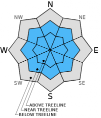
Storm snow avalanches will be most prevalent near and above treeline on all aspects. Avoid slopes steeper than 30 degrees and let the snow settle out and stabilize for a couple days. Give runout zones a wide berth or when you notice others traveling above. Test slopes, snow pits, slope cuts, previous tracks and cornice drops tend to provide some level of information on stability.
Recent Observations
The storm that began on Wednesday the 10th of December gave the Mt Shasta area a large dollup of new snow that came in mostly "right side up". That is, heavier snow on the bottom and lighter snow on the top. We like that. However, that being said, as much as 4 feet of snow fell in 48 hours and was accompanied with moderate, southwest winds...a red flag. Wind slabs and storm slabs are the avalanche problems of most concern currently.
Backcountry skiers yesterday came across some impressive debris of a large natural avalanche (HS-N-D3/4-R3/4) that slid down Avalanche Gulch proper and ran past the Horse Camp (Sierra Club) cabin. The avalanche likely occured on 12/11/14. Visibility was poor so knowbody got a good view of the starting zone and/or full extent of this slide. The avalanche came down through Avalanche Gulch proper, and not the "climbers gully". Thus, the starting zone was likely the Sargents Ridge, Thumb, Redbanks area. This slide is a good reminder of the potential for large avalanches on Mt Shasta during heavy winter storms. Slides like this can easily extend into runout zones on relatively flat terrain...ground that one might travel on and think they are not in avalanche terrain. Always know what slopes are above you and travel with caution even when below treeline. You may be in a runout zone.
I got a glimpse of the Old Ski Bowl yesterday and thought maybe I would see another large slide in the bowl, however the slopes remained intact. Today I remain a bit nervous: Its the weekend with clear skies forecasted....large wind and storm slabs still lingering...folks chomping at the bit to get perfect, untracked powder. Let's take all this into consideration.
While snow stability seemed good in below and near treeline areas, I continue to have concern for above treeline slopes today. Yesterday at 8,300 feet in the Old Ski Bowl, I was able to repeatedly get moderate failures 70cm down from the top of the snowpack with compression and extended column tests. Clean, quality 1 and 2 fractures were initiated with both tests at a density change in the snow, though full propagation did not occur with extended column tests. These tests were performed on an East facing slope, 30 degrees. At this pit location, 95cm of new snow was recorded. The top layers of snow measured in at 14-15% water content while the bottom layers of new snow came in at 15-16%. While full slope propagation might be difficult, a heavy, high marking snowmobile or skier on a very deep and unstable wind slab could create disaster.
Shooting cracks were observed by a couple local skiers near treeline on Green Butte Ridge yesterday.
Overall, folks have been able to find some great, safe, early season skiing at below and near treeline areas. It is advised to still stick to lower angle slopes for another few days and give runout zones plenty of room.
Three photos below: Avalanche Gulch slide. Photos taken on 12/12/14. Slide occured sometime likely on 12/11/14
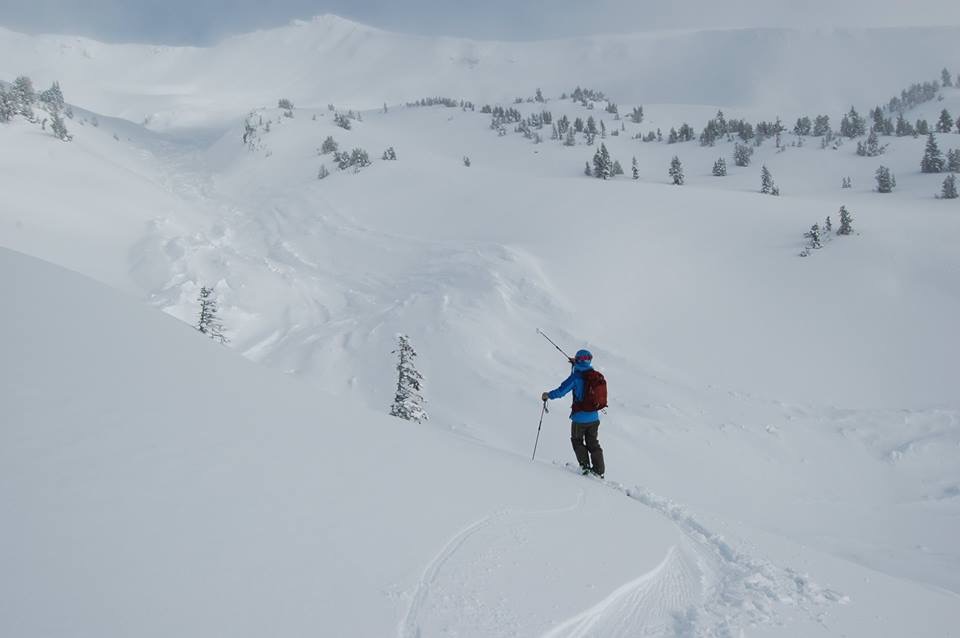
Photo: Chris Carr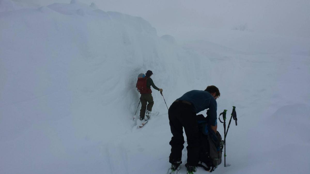
Photo: Chris Carr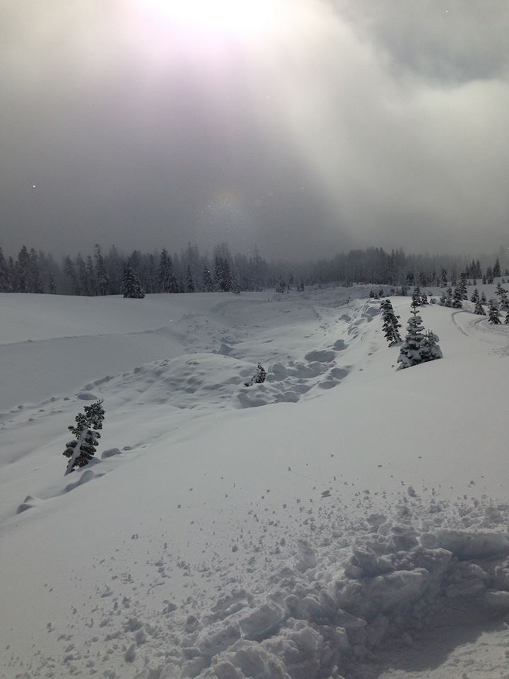
Photo: Angela Towner
Report your observations to the MSAC! A photo, a few words... send them in! (nimeyers@fs.fed.us or 530-926-9614)
Castle Lake area still has no snow.
Mt Eddy area is hosting about a 18" of snow. I have not been up into that area yet and have received no reports.
-------------------------------------------------------------------------------------------------------------------------------
Terrain: Remember most of the terrain that we like to play on is greater than 30 degrees. Avalanches are possible on anything steeper than 30 degrees. Avoid cornices, rock bands, terrain traps and runout zones of avalanche paths.
Weather: Most of our areas avalanche danger will occur 24-48 hours after a storm. We still can see persistent weak layers from time to time and we always will be sure to let you know about that! Heed the basic signs: Wind (significant snow transport and depositions), Temperature (rain/snow/rain/snow, which in turn weakens the snowpack), and Precipitation (Snow or rain add weight and stress to the current snowpack).
Snowpack: If snow accumulates, give the snowpack a chance to adjust to the new snow load before you play on or near steep slopes (greater than 30 degrees). Most direct action avalanches occur within 24-48 hours of recent snowfall. Watch for obvious signs of snowpack instability such as recent natural avalanche activity, collapsing of the snowpack (often associated with a “whumphing” sound), and shooting cracks. If you see these signs of instability, limit your recreation to lower angle slopes.
Human Factor: Don’t forget to carry and know how to use avalanche rescue gear. You should NOT be skiing or climbing potential avalanche slopes without having beacons, shovels, and probes. Only one person in a group should be exposed to potential avalanche danger at a time. Remember, climbing, skiing, and riding down the edge of slopes is safer than being in the center. Just because another person is on a slope doesn’t mean that it is safe. Be an individual! Make your own decisions. Heed the signs of instability: rapid warming, “whumphing” noises, shooting cracks, snowing an inch an hour or more, rain, roller balls, wind loading, recent avalanche activity.
The Five Red Flags of Avalanche Danger any time of year include: 1) Recent/current avalanche activity 2) Whumpfing sounds or shooting cracks 3) Recent/current heavy snowfall 4) Strong winds transporting snow 5) Rapid warming or rain on snow.
Weather and Current Conditions
Weather Summary
In Mt Shasta City this morning at 0500, we have a current temperature of 37 F with obscured skies with low lying fog/clouds.
WEATHER STATION INFORMATION (0500hrs):
On Mt Shasta (South Side) in the last 24 hours...
Old Ski Bowl - 7,600 feet, the current temperature of 18 F. Snow on the ground totals 67 inches with 1-2 inches of settlement. Storm total since 12/10/14 (Wednesday) is 50 inches. Temperatures have ranged from 18 F to 29 F.
Gray Butte - 8,000 feet, winds have averaged 7mph from the West/Northwest, with gusts to 28 mph from the Northwest. The current temperature is 19 F and temps have ranged from 19 F to 29 F in the last 24 hours.
Castle Lake and Mt Eddy (West side of Interstate-5)...
Castle Lake - 5,600 feet, the current temperature is 30 F. Temps have ranged from 30 F to 42 F in the last 24 hours. Castle has no snow on the ground yet.
Mt Eddy - 6,500 feet, the current temperature is 20 F. Temps have ranged from 20 F to 31 F in the last 24 hours. Current snow depth is 18 inches with 1-2" of new snow in the last 24 hours. Wind information was unavailable this morning.
WEATHER SYNOPSIS: Today should be the best break in the weather that we will see before another system moves into the area on Sunday afternoon. Rain and snow showers should begin late Sunday and we will see the heaviest precipitation amounts Monday night into Tuesday. Models show 3/4" to 1" of water possible with this storm. Snow levels will sit right around 4-5,000 feet. Winds will pick back up again out of the Soutwest on Monday and blow 20-30 mph at treeline and above treeline elevations.
THIS SEASON: Since September 1st , we have received 19.03 inches of water, normal is 10.85 inches, putting us at 175% of normal. For the year of 2014, Mt Shasta has received 31.31 inches of water with normal being 38.18 inches which puts us at 82% of normal. And lastly, for December we sit at 346% of normal, receiving 9.78 inches of water, normal is 2.82 inches.
Always check the weather before you attempt to climb Mt Shasta. Further, monitor the weather as you climb. Becoming caught on the mountain in any type of weather can compromise life and limb. Be prepared.
| 0600 temperature: | 18 |
| Max. temperature in the last 24 hours: | 29 |
| Average wind direction during the last 24 hours: | West - Northwest |
| Average wind speed during the last 24 hours: | 7 mi/hr |
| Maximum wind gust in the last 24 hours: | 28 mi/hr |
| New snowfall in the last 24 hours: | 1" - 3" inches |
| Total snow depth: | 67" inches |
Two Day Mountain Weather Forecast
Produced in partnership with the Medford NWS
| For 7000 ft to 9000 ft | |||
|---|---|---|---|
|
Saturday (4 a.m. to 10 p.m.) |
Saturday Night (10 p.m. to 4 a.m.) |
Sunday (4 a.m. to 10 p.m.) |
|
| Weather | Mostly sunny | Partly cloudy | Chance of snow after 10am |
| Temperature (°F) | 33 | 25 | 33 |
| Wind (mi/hr) | East, shifting to South 0-5 mph | Southeast 5-10 mph | South/Southeast 10-20 mph |
| Precipitation SWE / Snowfall (in) | / 0 | / 0 | / 0 - .5" |
| For 9000 ft to 11000 ft | |||
| Saturday | Saturday Night | Sunday | |
| Weather | Mostly sunny | Partly cloudy | Chance of snow after 10am |
| Temperature (°F) | 22 | 21 | 26 |
| Wind (mi/hr) | Northwest 5-15 mph | Southwest 0 | South 15-20 mph with gusts possible to 30 mph |
| Precipitation SWE / Snowfall (in) | / 0 | / 0 | / 0 - .5" |

