

You are here
Avalanche Advisory for 2014-12-19 07:02:26
- EXPIRED ON December 20, 2014 @ 7:02 amPublished on December 19, 2014 @ 7:02 am
- Issued by Nick Meyers - Shasta-Trinity National Forest
Bottom Line
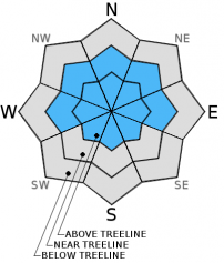
Human-triggered wind slab avalanches remain possible today in certain areas. MODERATE avalanche danger exist on wind-loaded W-NW-N-NE-E aspects, 35 degrees and steeper in near and above treeline terrain. Convex rollovers, areas near rocks, unsupported slopes, couloirs and gullies and other complex terrain represent the most likely places to find lingering wind slabs.


Avalanche Problem 1: Wind Slab
-
Character ?

-
Aspect/Elevation ?
-
Likelihood ?CertainVery LikelyLikelyPossible
 Unlikely
 -
Size ?HistoricVery LargeLargeSmall

Upper elevation (>8,500 feet) isolated areas in extreme terrain, bowls, wind loaded ridgelines, convex rollovers, areas near rocks, unsupported slopes, couloirs and gullies and other complex terrain represent the most likely places to find lingering wind slabs. MODERATE avalanche danger exist on wind-loaded W-NW-N-NE-E aspects, 35 degrees and steeper in near and above treeline terrain.
The avalanche danger is expected to increase as we move through today and Saturday. South to West moderate to breezy winds and up to 1 foot of new snow this weekend will instigate the rise in avalanche danger.
Recent Observations
Since last Sunday 12-14-14, Mt Shasta remained quite wintery with some good riding conditions at elevations above 6,500 feet. We never really got a good glimpse of the mountain due to low visibility, and snow showers over the course of the week brought 21 inches of new snow....recorded at the Old Ski Bowl weather station, 7,600 feet. Temperatures remained low enough over the week to keep things soft and fresh, however yesterday we saw a spike in temp and the snow conditions suffered a bit up to about 8,000 feet or a bit higher. Effect was in the form of a thin zipper crust in below and near treeline areas and overall density increase in the top layers of the snowpack.
Speaking snow stability, on 12-17-14, we had one skier triggered wind slab avalanche on the NW facing aspect of Gray Butte. The crown was 1 to 1.5 feet deep and approx. 30 feet wide. The slide was slow moving and arrested after only about 50 feet and the skier was not caught. The weak layer is unknown, however the slide was within the new snow layers. This slide was likely a small, sensitive, wind loaded pocket that we often see form on Gray Butte. Southerly storms can easily cross-load slopes on the NW side of the butte.
Also on Wednesday the 17th, a few local skiers reported some small surface sloughs in the same area of Gray Butte.
Yesterday, several reports from the backcountry reported stable conditions and no eye opening results from stability tests.
Concern was stated last week for new snow on top of the fairly widespread surface hoar layer that formed last weekend (picture below). New snow accumulation occured at a slow rate over the week and the snowpack likes that. Warmer temperatures at times has decomposed the buried surface hoar layer and doesn't seem to be an issue currently. It is possible that sheltered, cold, north facing aspects above 8,500 feet could see persistent, buried surface hoar layers still present and pose as a potential weak layer.
As of this morning, we overall sit in low to moderate avalanche danger. It will be interesting to see how the weekend unfolds. WIth up to a foot of new snow expected, moderate to windy south to west winds and temperatures working from cool to warm, this could give us the upside down cake problem: lighter snow on the bottom, heavier snow on the top. Add in wind loading and pockets of buried surface hoar and I wouldn't be surprised to see the avalanche danger rise to considerable at some point near and above treeline. I suspect these isolated pockets of instability to be at upper elevations (>8,500 feet) on NW-N-NE-E aspects.
(Widespread surface hoar from last weekend, this photo from the north ridge of Gray Butte. NOTE: If you are viewing this picture from a mobile device, it's likely upside down. We have no idea why. It appears right side up on our computer! Sorry! Photo: Meyers)
Report your observations to the MSAC! A photo, a few words... send them in! (nimeyers@fs.fed.us or 530-926-9614)
Castle Lake area still has very little snow.
Mt Eddy area is hosting about 34 inches of snow in Wagon Bowl. I have not been up into that area yet and have received no reports.
Sand Flat Winter Trails: OPEN
-------------------------------------------------------------------------------------------------------------------------------
Terrain: Remember most of the terrain that we like to play on is greater than 30 degrees. Avalanches are possible on anything steeper than 30 degrees. Avoid cornices, rock bands, terrain traps and runout zones of avalanche paths.
Weather: Most of our areas avalanche danger will occur 24-48 hours after a storm. We still can see persistent weak layers from time to time and we always will be sure to let you know about that! Heed the basic signs: Wind (significant snow transport and depositions), Temperature (rain/snow/rain/snow, which in turn weakens the snowpack), and Precipitation (Snow or rain add weight and stress to the current snowpack).
Snowpack: If snow accumulates, give the snowpack a chance to adjust to the new snow load before you play on or near steep slopes (greater than 30 degrees). Most direct action avalanches occur within 24-48 hours of recent snowfall. Watch for obvious signs of snowpack instability such as recent natural avalanche activity, collapsing of the snowpack (often associated with a “whumphing” sound), and shooting cracks. If you see these signs of instability, limit your recreation to lower angle slopes.
Human Factor: Don’t forget to carry and know how to use avalanche rescue gear. You should NOT be skiing or climbing potential avalanche slopes without having beacons, shovels, and probes. Only one person in a group should be exposed to potential avalanche danger at a time. Remember, climbing, skiing, and riding down the edge of slopes is safer than being in the center. Just because another person is on a slope doesn’t mean that it is safe. Be an individual! Make your own decisions. Heed the signs of instability: rapid warming, “whumphing” noises, shooting cracks, snowing an inch an hour or more, rain, roller balls, wind loading, recent avalanche activity.
The Five Red Flags of Avalanche Danger any time of year include: 1) Recent/current avalanche activity 2) Whumpfing sounds or shooting cracks 3) Recent/current heavy snowfall 4) Strong winds transporting snow 5) Rapid warming or rain on snow.
Weather and Current Conditions
Weather Summary
In Mt Shasta City this morning at 0500, we have a current temperature of 41 F and lightly raining.
WEATHER STATION INFORMATION (0500hrs):
On Mt Shasta (South Side) in the last 24 hours...
Old Ski Bowl - 7,600 feet, the current temperature of 26 F. Snow on the ground totals 86 inches with 1-2 inches settlement. Storm total since last Sunday 12/14/14 is 21 inches. New snow in the last 24 hours totals 4 inches. Temperatures have ranged from 24 F to 31 F.
Gray Butte - 8,000 feet, winds have averaged 10mph from the West, with gusts to 21 mph from the West. The current temperature is 25 F and temps have ranged from 23 F to 27 F in the last 24 hours.
Castle Lake and Mt Eddy (West side of Interstate-5)...
Castle Lake - 5,600 feet, the current temperature is 32 F. Temperature high and low are unknown at this time due to instrument malfunction. Castle has a couple inches of snow on the ground.
Mt Eddy - 6,500 feet, the current temperature is 29 F. Temps have ranged from 27 F to 32 F in the last 24 hours. Current snow depth is 34 inches with 4 inches new snow in the last 24 hours. Mt Eddy received 15 inches new snow since last Sunday (12/14/14). Winds averaged 2 mph out of the South with gusts to 10 mph, SSW.
WEATHER SYNOPSIS: A wet and wild weekend is potentially in store for us in Mt Shasta. Models are showing the full gamut of weather: precipitation, wind and inconsistent temperatures. In the grand scheme of things, we will see precip falling most of the weekend with up to 1 inch of water by early Sunday. While this is exciting, the temperatures are not. This morning temperatures are below freezing on the mountain with snow levels near 5,000 feet. As we move into Saturday, temps will begin to warm and by Saturday night, snow levels are expected to sky rocket to 9,000 feet. Winds at the mid mountain level will blow for most of the weekend out of the Southwest/West 20-30 mph with gusts and periods of increased wind into the 50-60mph range. Precip will drop off by Sunday evening for a couple days followed by a cold front for just maybe, a white Christmas.
THIS SEASON: Since September 1st , we have received 20.82 inches of water, normal is 12.42 inches, putting us at 167% of normal. For the year of 2014, Mt Shasta has received 33.10 inches of water with normal being 39.75 inches which puts us at 83% of normal. And lastly, for December we sit at 263% of normal, receiving 11.57 inches of water, normal is 4.39 inches.
Always check the weather before you attempt to climb Mt Shasta. Further, monitor the weather as you climb. Becoming caught on the mountain in any type of weather can compromise life and limb. Be prepared.
| 0600 temperature: | 26 |
| Max. temperature in the last 24 hours: | 31 |
| Average wind direction during the last 24 hours: | Westerly |
| Average wind speed during the last 24 hours: | 10 mi/hr |
| Maximum wind gust in the last 24 hours: | 21 mi/hr |
| New snowfall in the last 24 hours: | 4 inches |
| Total snow depth: | 86 inches |
Two Day Mountain Weather Forecast
Produced in partnership with the Medford NWS
| For 7000 ft to 9000 ft | |||
|---|---|---|---|
|
Friday (4 a.m. to 10 p.m.) |
Friday Night (10 p.m. to 4 a.m.) |
Saturday (4 a.m. to 10 p.m.) |
|
| Weather | Snow showers | Snow, mostly after 10pm | Snow |
| Temperature (°F) | 33 | 26 | 37 |
| Wind (mi/hr) | South/Southwest 15-25 mph | South 10-20 mph | Southwest/West 10-20 mph, increasing to 20-30 mph |
| Precipitation SWE / Snowfall (in) | / 1-3 | / 1-3 | / 2" - 4" |
| For 9000 ft to 11000 ft | |||
| Friday | Friday Night | Saturday | |
| Weather | Snow showers | Snow | Snow |
| Temperature (°F) | 27 | 20 | 32 |
| Wind (mi/hr) | West/Southwest 40-50 mph this morning, decreasing to 20-30 mph this afternoon, Westerly | Southwest 2-4 | West 40-50 mph, increasing to 50-60 mph |
| Precipitation SWE / Snowfall (in) | / 2-4 | / 2-4 | / 3-7 |

