

You are here
Avalanche Advisory for 2014-12-20 07:07:43
- EXPIRED ON December 21, 2014 @ 7:07 amPublished on December 20, 2014 @ 7:07 am
- Issued by Nick Meyers - Shasta-Trinity National Forest
Bottom Line
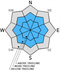
For near and above treeline areas today, MODERATE avalanche danger will exist for wind and storm slab avalanches. As the day progresses, the avalanche danger could rise to CONSIDERABLE.
Poor visibility above treeline in the past few days has produced a lack of observations and uncertainty for these areas. Weather and snow predictions point to unfavorable stabilty. One must proceed with caution once the skies clear and skiers and riders venture upwards.


Avalanche Problem 1: Wind Slab
-
Character ?

-
Aspect/Elevation ?

-
Likelihood ?CertainVery LikelyLikelyPossible
 Unlikely
 -
Size ?HistoricVery LargeLargeSmall

Upper elevation (>8,500 feet) areas will be the most likely places to find wind slabs. MODERATE avalanche danger, potentially increasing to CONSIDERABLE avalanche danger today will exist on wind-loaded aspects, 35 degrees and steeper, near and above treeline.
Avalanche Problem 2: Storm Slab
-
Character ?

-
Aspect/Elevation ?
-
Likelihood ?CertainVery LikelyLikelyPossible
Unlikely
-
Size ?HistoricVery LargeLargeSmall
Storm snow avalanches are possible for near and above treeline areas. These avalanches will be small to medium in size and most likely on steepr slopes (>37 degrees) in extreme terrain, leeward aspects near ridgetops, bowls, couloirs, convex rollovers, and near rocks.
Recent Observations
Over the course of this past week, we have seen upwards of two feet of new snow. A slow trickle of precip has added snow slowly to our snowpack over the week and allowed for favorable stability for sliders and riders below and near treeline areas. Visibility has been poor and yesterday the 'soup de jour' was split pea. At 7,900 feet, 1145 hours, the temperature was 32 degrees with a light mist and intermittent snow/ice pellets. Brief glimpses of blue sky occured but never lasted. The snow conditions in general below and near treeline were DEEP and pretty heavy. Snow density measurements recorded 20% water content within the top layers of the snowpack. All said, our December base is looking great!
The surface hoar layer that formed earlier in the week and was subsequently covered by new snow was difficult to find yesterday in pit profiles. Warm temperatures have eliminated this weak layer and it doesn't seem to be a probelm any longer. Bless our maritime snowpack for this.
Total snow depth observed at 7,900 feet at the top of T-Bar was 240cm. A 157cm deep snow pit revealed an isothermal snow mass with no temperature gradients. Stability test scores (extended column tests) were all in the 20-30 range with poor shear (ECTN26@105cm/ECTN21@105cm). This "weak" layer consisted of a density change in the snowpack.
The big picture: Below and near treeline snow stability seems very good. Lack of observations for above treeline areas leaves some uncertainty for these areas once the clouds begin to part. We have a number of variables that are not particularly favorable for a stable snowpack above treeline. These are: recent new snow and no recent upper mountain observations, rising temperatures/snow level (upside down cake effect), additional snow in the forecast (5-9 inches >10,000 feet) today and finally strong west/northwest winds on tap (mid to upper mountain levles - 50-60 mph). Once again as we saw last weekend, once the visibility improves and folks venture above treeline, extra caution should be exercised!
Small to large, wind and storm slab avalanches will be the avalanche problems for this weekend and could be found on all aspects, mid to upper mountain levels. Stay clear of lower angle run out zones, leeward aspects near ridgetops, bowls, extreme terrain, couloirs, convex rollovers, and near rocks.
Report your observations to the MSAC! A photo, a few words... send them in! (nimeyers@fs.fed.us or 530-926-9614)
Castle Lake area still has very little snow.
Mt Eddy area is hosting about 34 inches of snow in Wagon Bowl. I have not been up into that area yet and have received no reports.
Sand Flat Winter Trails: OPEN
-------------------------------------------------------------------------------------------------------------------------------
Terrain: Remember most of the terrain that we like to play on is greater than 30 degrees. Avalanches are possible on anything steeper than 30 degrees. Avoid cornices, rock bands, terrain traps and runout zones of avalanche paths.
Weather: Most of our areas avalanche danger will occur 24-48 hours after a storm. We still can see persistent weak layers from time to time and we always will be sure to let you know about that! Heed the basic signs: Wind (significant snow transport and depositions), Temperature (rain/snow/rain/snow, which in turn weakens the snowpack), and Precipitation (Snow or rain add weight and stress to the current snowpack).
Snowpack: If snow accumulates, give the snowpack a chance to adjust to the new snow load before you play on or near steep slopes (greater than 30 degrees). Most direct action avalanches occur within 24-48 hours of recent snowfall. Watch for obvious signs of snowpack instability such as recent natural avalanche activity, collapsing of the snowpack (often associated with a “whumphing” sound), and shooting cracks. If you see these signs of instability, limit your recreation to lower angle slopes.
Human Factor: Don’t forget to carry and know how to use avalanche rescue gear. You should NOT be skiing or climbing potential avalanche slopes without having beacons, shovels, and probes. Only one person in a group should be exposed to potential avalanche danger at a time. Remember, climbing, skiing, and riding down the edge of slopes is safer than being in the center. Just because another person is on a slope doesn’t mean that it is safe. Be an individual! Make your own decisions. Heed the signs of instability: rapid warming, “whumphing” noises, shooting cracks, snowing an inch an hour or more, rain, roller balls, wind loading, recent avalanche activity.
The Five Red Flags of Avalanche Danger any time of year include: 1) Recent/current avalanche activity 2) Whumpfing sounds or shooting cracks 3) Recent/current heavy snowfall 4) Strong winds transporting snow 5) Rapid warming or rain on snow.
Weather and Current Conditions
Weather Summary
In Mt Shasta City this morning at 0500, we have a current temperature of 41 degrees with a light mist/rain falling.
WEATHER STATION INFORMATION (0500hrs):
On Mt Shasta (South Side) in the last 24 hours...
Old Ski Bowl - 7,600 feet, the current temperature is 27 F. Snow on the ground totals 88 inches with 1 inch settlement. New snow in the last 24 hours totals 1-2 inches. Temperatures have ranged from 26 F to 30 F. Storm total since last Sunday 12/14/14 is 23 inches.
Gray Butte - 8,000 feet, winds have averaged 15mph from the West, with gusts to 35 mph from the WNW. The current temperature is 26 F and temps have ranged from 25 F to 29 F in the last 24 hours.
Castle Lake and Mt Eddy (West side of Interstate-5)...
Castle Lake - 5,600 feet, the current temperature is 42 F. Temperature and other weather information are unknown at this time due to instrument malfunction. We are working on this problem. The Castle Lake area has a couple inches of snow on the ground.
Mt Eddy - 6,500 feet, the current temperature is 29 F. Temps have ranged from 29 F to 31 F in the last 24 hours. Current snow depth is 36 inches with .5-1 inch new snow and 1 inch settlement in the last 24 hours. Mt Eddy received 17 inches new snow since last Sunday (12/14/14). Winds averaged 1 mph out of the SE with gusts to 10 mph, ESE.
WEATHER SYNOPSIS: A 3,000 mile plum of moisture extending out into the Pacific and West/Northwest flow has Oregon and the Cascades begging for mercy. Five to seven inches of rain is expected for some Oregon Coast areas which has the NWS issuing flood watches/warnings! As for us here in the little hamlet of Mt Shasta, West/Northwest flow is not favorable for our area and we will only get the southern edge of this storm. This will mean about .75 inches of water today and windy conditions, 10,000 feet and above. Temperatures will rise as the day progresses... expect snow levels to start as low as 5,500 feet and gain the 9,500 foot mark by nightfall. Hopefully as snow levels rise, most of the precip will have fallen and prevent to much rain on snow. Yuck! Winds will be very strong at mid and upper mountain levels all weekend. Flow is mostly West at this time, though winds will shift to NW tonight and blow steadily, 30-40 mph with gusts into the 50-60 mph range.
THIS SEASON: Since September 1st , we have received 21.42 inches of water, normal is 12.71 inches, putting us at 168% of normal. For the year of 2014, Mt Shasta has received 33.70 inches of water with normal being 40.04 inches which puts us at 84% of normal. And lastly, for December we sit at 260% of normal, receiving 12.17 inches of water, normal is 4.68 inches.
Always check the weather before you attempt to climb Mt Shasta. Further, monitor the weather as you climb. Becoming caught on the mountain in any type of weather can compromise life and limb. Be prepared.
| 0600 temperature: | 27 |
| Max. temperature in the last 24 hours: | 30 |
| Average wind direction during the last 24 hours: | Westerly |
| Average wind speed during the last 24 hours: | 15 mi/hr |
| Maximum wind gust in the last 24 hours: | 35 mi/hr |
| New snowfall in the last 24 hours: | 1-2 inches |
| Total snow depth: | 88 inches |
Two Day Mountain Weather Forecast
Produced in partnership with the Medford NWS
| For 7000 ft to 9000 ft | |||
|---|---|---|---|
|
Saturday (4 a.m. to 10 p.m.) |
Saturday Night (10 p.m. to 4 a.m.) |
Sunday (4 a.m. to 10 p.m.) |
|
| Weather | Snow | Rain | Lingering rain showers |
| Temperature (°F) | 38 | 36 | 45 |
| Wind (mi/hr) | Southwest/West 10-20 mph | West 15-25 mph | West 15-25 mph |
| Precipitation SWE / Snowfall (in) | / 3-5 | / .10-.25 water | / 0 |
| For 9000 ft to 11000 ft | |||
| Saturday | Saturday Night | Sunday | |
| Weather | Snow | Snow | Chance of snow, Partly sunny |
| Temperature (°F) | 31 | 30 | 37 |
| Wind (mi/hr) | West 50-60 mph | West/Northwest 5-9 | Northwest 50-60 mph |
| Precipitation SWE / Snowfall (in) | / 5-9 | / 1-3 | / 0-1 |

