

You are here
Avalanche Advisory for 2014-12-21 06:55:34
- EXPIRED ON December 22, 2014 @ 6:55 amPublished on December 21, 2014 @ 6:55 am
- Issued by Nick Meyers - Shasta-Trinity National Forest
Bottom Line
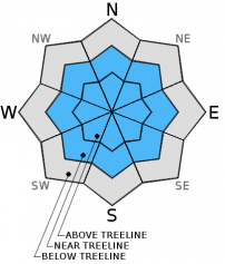
Above treeline on Mt Shasta, the avalanche danger remains MODERATE with areas of CONSIDERABLE danger on NE-E-SE-S facing slopes. Concern remains for wind slab avalanches.
Once again yesterday, very poor visibility and lack of observations above treeline has created much uncertainty for the alpine areas. The mountain has seen a steady stream of new snow over the weekend along with moderate to strong winds out of the west/northwest. Careful route choice and snow evaluation will be essential to avoid trouble!


Avalanche Problem 1: Wind Slab
-
Character ?

-
Aspect/Elevation ?
-
Likelihood ?CertainVery LikelyLikelyPossible
 Unlikely
 -
Size ?HistoricVery LargeLargeSmall

Near and above treeline areas will be the most likely places to find wind slabs. MODERATE avalanche danger with pockets of CONSIDERABLE avalanche danger will exist on wind-loaded aspects, 35 degrees and steeper. Wind slabs could be small to large in size.
Wind slabs will be most sensitive to trigger in the next 24-48 hours. Warming temps could increase sensitivity of triggering said slabs.
Wind slabs are often smooth and rounded and sometimes sound hollow, and can range from soft to hard / predictable to unpredictable due to slab stiffness and spatial variability.
Avoid avalanche terrain with recent wind deposits or choose slopes gentler than 30 degrees in steepness. Wind slabs tend to stabilize within a few days unless deposited on a persistent weak layer.
Give runout zones a wide berth when natural avalanches are expected or when others may be traveling above you. Remotely triggered slides are possible during heavy wind loading events.
Recent Observations
Snow sliders and riders stomachs are plum full from a steady diet of pea soup in the recent days. All were busy wiping the goggles off their foggles to retain visibility as the snow levels fluctuated and the precip fell in the form of mist/rain/ice and/or snow pellets. The mountain received a couple inches of new snow yesterday at Bunny Flat (6,950 feet) and a bit more up higher. The downright deep conditions experienced on Friday settled out yesterday and provided more supportable powder. In general, warmer temps had the snow on the sticky/heavy side... though I still didn't hear any complaints!
Below treeline avalanche danger remains low. That said, a lack of observations has created a lot of uncertainty for all areas above treeline and folks need to take note of this. The mountain is hosting a couple variables that are favorable for wind slab development and an unstable snowpack. These are: a steady stream of new snow over the past several days, moderate to strong west/northwest winds, warming temps. We've got snow to transport and winds to do so and thus wind slab avalanches will be of most concern for the next couple days. Warming temps could also further contribute to instability. As always, one will to need to bring out their 'A' game when the skies begin to part and adventures begin on the upper mountain.
This morning, the Bunny Flat area was seeing a massive tree drip event and likely a several inch snowpack consolidation due to the temperature rise. This will continue into today. Wind slabs will be most sensitive to trigger in the next 24-48 hours. Warming temps today could also contribute to increased sensitvity to triggering of said slabs.
Total snow depth observed at 7,900 feet at the top of T-Bar was 240cm on 12-19-14. A 157cm deep, East facing snow pit revealed an isothermal snow mass with no temperature gradients. Stability test scores (extended column tests) were all in the 20-30 range with poor shear (ECTN26@105cm/ECTN21@105cm). This "weak" layer consisted of a density change in the snowpack.
Report your observations to the MSAC! A photo, a few words... send them in! (nimeyers@fs.fed.us or 530-926-9614)
Castle Lake area still has very little snow and no skiing is being had yet.
Mt Eddy area is hosting about 2-3 feet of snow in Wagon Bowl. I have not been up into that area yet and have received no reports.
Sand Flat Winter Trails: OPEN and in good shape!
Pilgrim Creek Snowmobile Park: OPEN, however due to lack of low elevation snow, one must drive up the road a few miles before enough snow is encountered.
-------------------------------------------------------------------------------------------------------------------------------
Terrain: Remember most of the terrain that we like to play on is greater than 30 degrees. Avalanches are possible on anything steeper than 30 degrees. Avoid cornices, rock bands, terrain traps and runout zones of avalanche paths.
Weather: Most of our areas avalanche danger will occur 24-48 hours after a storm. We still can see persistent weak layers from time to time and we always will be sure to let you know about that! Heed the basic signs: Wind (significant snow transport and depositions), Temperature (rain/snow/rain/snow, which in turn weakens the snowpack), and Precipitation (Snow or rain add weight and stress to the current snowpack).
Snowpack: If snow accumulates, give the snowpack a chance to adjust to the new snow load before you play on or near steep slopes (greater than 30 degrees). Most direct action avalanches occur within 24-48 hours of recent snowfall. Watch for obvious signs of snowpack instability such as recent natural avalanche activity, collapsing of the snowpack (often associated with a “whumphing” sound), and shooting cracks. If you see these signs of instability, limit your recreation to lower angle slopes.
Human Factor: Don’t forget to carry and know how to use avalanche rescue gear. You should NOT be skiing or climbing potential avalanche slopes without having beacons, shovels, and probes. Only one person in a group should be exposed to potential avalanche danger at a time. Remember, climbing, skiing, and riding down the edge of slopes is safer than being in the center. Just because another person is on a slope doesn’t mean that it is safe. Be an individual! Make your own decisions. Heed the signs of instability: rapid warming, “whumphing” noises, shooting cracks, snowing an inch an hour or more, rain, roller balls, wind loading, recent avalanche activity.
The Five Red Flags of Avalanche Danger any time of year include: 1) Recent/current avalanche activity 2) Whumpfing sounds or shooting cracks 3) Recent/current heavy snowfall 4) Strong winds transporting snow 5) Rapid warming or rain on snow.
Weather and Current Conditions
Weather Summary
In Mt Shasta City this morning at 0500, we have a current temperature of 45 degrees with obscured skies.
WEATHER STATION INFORMATION (0500hrs):
On Mt Shasta (South Side) in the last 24 hours...
Old Ski Bowl - 7,600 feet, the current temperature is 33 F. Snow on the ground totals 88 inches with 1-2 inches settlement. New snow in the last 24 hours totals 2-3 inches. Temperatures have ranged from 26 F to 33 F. Storm total since last Sunday (12/14/14) is 23 inches.
Gray Butte - 8,000 feet, winds have averaged 15mph from the WNW, with gusts to 35 mph from the WNW. The current temperature is 31 F and temps have ranged from 25 F to 31 F in the last 24 hours.
Castle Lake and Mt Eddy (West side of Interstate-5)...
Castle Lake - 5,600 feet, Current weather information from the Casle Lake station is currently unavailable. We are working on this issue. The Castle Lake area has a couple inches of snow on the ground and is not hosting any skiing at this time.
Mt Eddy - 6,500 feet, the current temperature is 42 F. Temps have ranged from 29 F to 42 F in the last 24 hours. Current snow depth is 35 inches with .5-1 inch new snow and 1 inch settlement in the last 24 hours. Mt Eddy received 17 inches new snow since last Sunday (12/14/14). Winds have averaged 2 mph out of the SE with gusts to 13 mph, SSE.
WEATHER SYNOPSIS: The focus of the recent storm has been Southern Oregon and the coastal areas. A 24 hour rainfall total near 9 inches has been recorded near the Curry County Coast. The East Fork of the Coquille near Sitkum overflowed its banks as well as other area flooding. While Southern Oregon continues to get drenched, our weekend storm is loosing steam this morning and we will see a gradual clearing for the Mt Shasta area today. Locally, lingering snow and rain showers will give us up to .14 inches more of water, mostly during the AM hours. Snow levels will hover around treeline on the mountain (8,000 feet) for the first half of the day and rise to 9-10,000 feet by this evening...though most of the precip will have passed by then. General weather flow will turn to the northwest and with that bring windy conditions for the mid and upper mountain levels for the next few days. Leading up to Christmas, we can expect partly cloudy skies and mild temperatures. For Christmas eve/day, Santa just might give us a sprinkle of holiday cheer with .14 inches of water and snow levels around 4,500 feet. Exact timing of this cold front is uncertain, but it's looking likely that Santa will have at least a skiff of snow to grease the skids on rooftops.
THIS SEASON: Since September 1st , we have received 21.60 inches of water, normal is 12.99 inches, putting us at 166% of normal. For the year of 2014, Mt Shasta has received 33.88 inches of water with normal being 40.32 inches which puts us at 84% of normal. And lastly, for December we sit at 248% of normal, receiving 12.35 inches of water, normal is 4.96 inches.
Brett Lutz, from the NWS in Medford, was checking records recently and said "I think Mt Shasta City has recorded one of the top 10 wettest Decembers since 1948!" Cool! We definitely need it! Thanks Brett for that tid bit!
Always check the weather before you attempt to climb Mt Shasta. Further, monitor the weather as you climb. Becoming caught on the mountain in any type of weather can compromise life and limb. Be prepared.
| 0600 temperature: | 33 |
| Max. temperature in the last 24 hours: | 33 |
| Average wind direction during the last 24 hours: | WNW |
| Average wind speed during the last 24 hours: | 15 mi/hr |
| Maximum wind gust in the last 24 hours: | 35 mi/hr |
| New snowfall in the last 24 hours: | 1-2 inches |
| Total snow depth: | 88 inches |
Two Day Mountain Weather Forecast
Produced in partnership with the Medford NWS
| For 7000 ft to 9000 ft | |||
|---|---|---|---|
|
Sunday (4 a.m. to 10 p.m.) |
Sunday Night (10 p.m. to 4 a.m.) |
Monday (4 a.m. to 10 p.m.) |
|
| Weather | Rain | Mostly to partly cloudy | Mostly sunny |
| Temperature (°F) | 48 | 35 | 47 |
| Wind (mi/hr) | West/Northwest 15-25 mph | Northwest 15-20mph | Northwest 20-30mph |
| Precipitation SWE / Snowfall (in) | / .10-.25 water | / 0 | / 0 |
| For 9000 ft to 11000 ft | |||
| Sunday | Sunday Night | Monday | |
| Weather | Snow | Mostly to partly cloudy | Mostly sunny |
| Temperature (°F) | 38 | 26 | 40 |
| Wind (mi/hr) | West/Northwest 50-60 mph | Northwest 1-2 | Northwest 50-60 mph |
| Precipitation SWE / Snowfall (in) | / 1-2 | / 0 | / 0 |

