

You are here
Avalanche Advisory for 2014-12-26 07:06:10
- EXPIRED ON December 27, 2014 @ 7:06 amPublished on December 26, 2014 @ 7:06 am
- Issued by Nick Meyers - Shasta-Trinity National Forest
Bottom Line
Northwest winds over the past week in near and above treeline areas have created pockets of MODERATE avalanche danger for human-triggered, wind slab avalanches on all aspects steeper than 35 degrees. Of most concern will be above treeline on Mt Shasta.
Medium to hard density wind slabs will sit on top of old, icy and generally bullet proof snow. Local orographics have created wind slabs not only on leeward S-SE-E aspects, but on other aspects as well.


Avalanche Problem 1: Wind Slab
-
Character ?

-
Aspect/Elevation ?
-
Likelihood ?CertainVery LikelyLikelyPossible
 Unlikely
 -
Size ?HistoricVery LargeLargeSmall

Near and above treeline areas will be the most likely places to find wind slabs. MODERATE avalanche danger will exist on wind-loaded aspects, 35 degrees and steeper. Wind slabs could be small to large in size, 1-3 feet deep.
Wind slabs are often smooth and rounded and sometimes sound hollow, and can range from soft to hard / predictable to unpredictable due to slab stiffness and spatial variability.
Avoid avalanche terrain with recent wind deposits or choose slopes gentler than 30 degrees in steepness. Wind slabs tend to stabilize within a few days unless deposited on a persistent weak layer.
Give runout zones a wide berth when natural avalanches are expected or when others may be traveling above you. Remotely triggered slides are possible during heavy wind loading events.
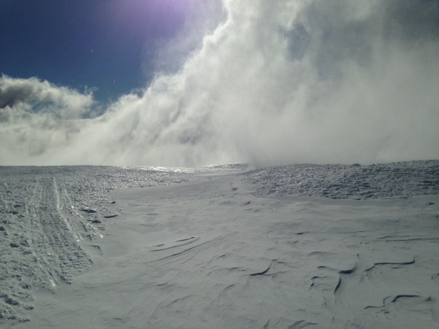
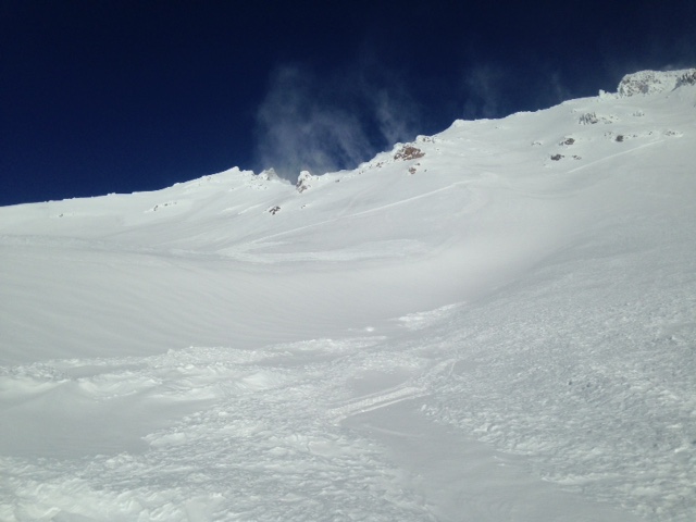
Areas of wind blown powder. This shot taken at 9,000 feet in the Old Ski Bowl on 12.25.14
Notice the nice and shiny, icy and otherwise bullet proof surrounding snow. Pockets of wind blown powder and/or wind slabs will be found above treeline on the mountain today. Slopes with wind deposited snow that look like this on slopes steeper than 35 degrees will be most suspect for human triggered avalanches. Slabs could be 1-3 feet thick and stubborn to sensitive to trigger.
Recent Observations
Greetings and Happy Holidays to all! The Mt Shasta snowpack took a big hit due to warming temperatures beginning late last weekend. Saturday night and into Sunday, the area saw temperatures rise rapidly creating a massive tree drip and consolidation of the snowpack. Over Christmas week, we experienced several more warm days leading to further consolidation. Since last Sunday the 21st, the Old Ski Bowl weather station reported 10 inches of settlement. Runnels from warm temps began to take form all the way up to about 9,000 feet over the week.
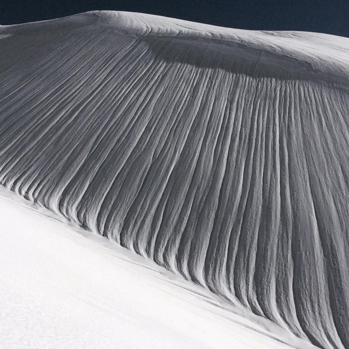
Runnels from warming over the past week. {Photo: C. Carr}
Northwest flow has been dominating and providing windy conditions on the mountain for most of the week. We've seen gusts to 92 mph and average wind speeds of 40-60 mph at times. Below treeline, the 4-6 inches of new snow that fell near Christmas Day has blown in fairly evenly in the trees, however it's by no means good skiing. Areas of deeper wind blown powder can be immediatly followed by bullet proof ice/snow as one slides down the hill.
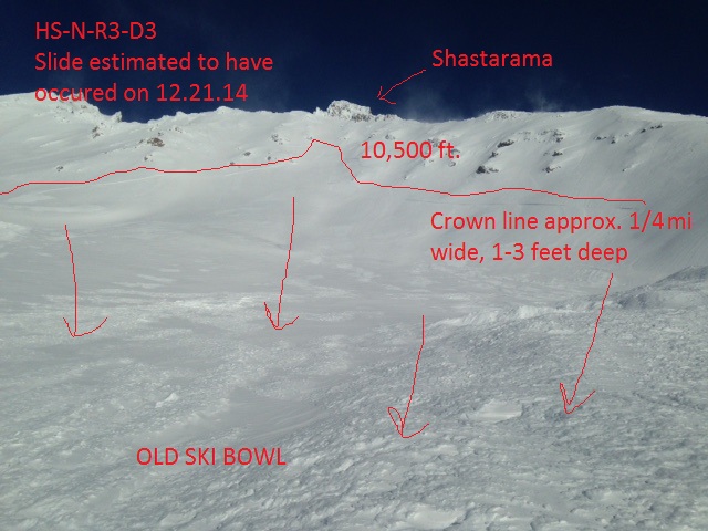
Wind loading of leeward slopes and the formation of wind slabs has and will be the current avalanche problem. Last weekend, sometime late Saturday or Sunday (visibility very poor until Monday), a large and impressive slide occured in the Old Ski Bowl (HS-N-R3-D3). The crown of this slide was approximately 1/4 mile wide and 1-3 feet deep. The starting zone was from 10 to 10,500 feet and the toe of the debris ended at 8,300 feet. This slide is another good reminder to remain aware of the terrain AND potential for avalanche danger ABOVE you. Conditions and avalanche danger can vary greatly as elevation changes. While one might experience low avalanche danger below and near treeline, the danger can be much higher on the upper mountain.
Above treeline yesterday, northwest winds were visually obvious off Casaval and Sargents Ridgelines. Keep in mind however, due to local orographics, winds can blow in different directions than the primary flow aloft. This can and will create wind loading on slopes not immediately thought of. Snow conditions overall are bullet proof and icy with mixed pockets and pillows of wind blown powder. One will find the best skiing in low angle, wind loaded gullies and depressions... or we will have to wait for a melt/freeze cycle!
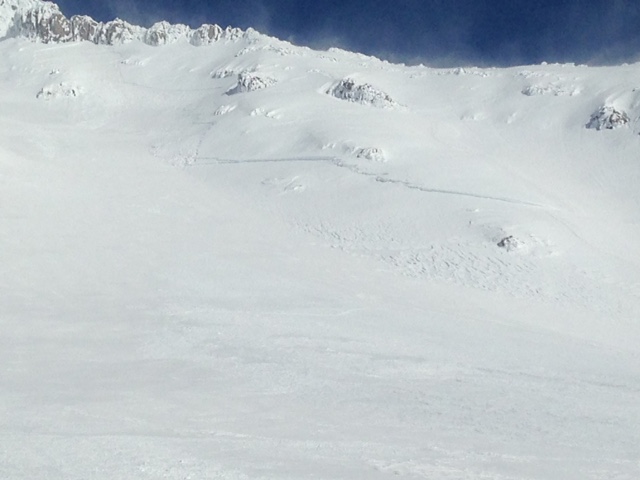
Old Ski Bowl Slide... the entire crown line wouldn't fit in the camera frame! Lookers left and right crown lines, five days later.
Report your observations to the MSAC! A photo, a few words... send them in! (nimeyers@fs.fed.us or 530-926-9614)
Castle Lake area still has very little snow and no skiing is being had yet.
Mt Eddy area is hosting about 2-3 feet of snow in Wagon Bowl. I have not been up into that area yet and have received no reports.
Sand Flat Winter Trails: OPEN and in good shape!
Pilgrim Creek Snowmobile Park: OPEN, however due to lack of low elevation snow, one must drive up the road a few miles before enough snow is encountered.
-------------------------------------------------------------------------------------------------------------------------------
Terrain: Remember most of the terrain that we like to play on is greater than 30 degrees. Avalanches are possible on anything steeper than 30 degrees. Avoid cornices, rock bands, terrain traps and runout zones of avalanche paths.
Weather: Most of our areas avalanche danger will occur 24-48 hours after a storm. We still can see persistent weak layers from time to time and we always will be sure to let you know about that! Heed the basic signs: Wind (significant snow transport and depositions), Temperature (rain/snow/rain/snow, which in turn weakens the snowpack), and Precipitation (Snow or rain add weight and stress to the current snowpack).
Snowpack: If snow accumulates, give the snowpack a chance to adjust to the new snow load before you play on or near steep slopes (greater than 30 degrees). Most direct action avalanches occur within 24-48 hours of recent snowfall. Watch for obvious signs of snowpack instability such as recent natural avalanche activity, collapsing of the snowpack (often associated with a “whumphing” sound), and shooting cracks. If you see these signs of instability, limit your recreation to lower angle slopes.
Human Factor: Don’t forget to carry and know how to use avalanche rescue gear. You should NOT be skiing or climbing potential avalanche slopes without having beacons, shovels, and probes. Only one person in a group should be exposed to potential avalanche danger at a time. Remember, climbing, skiing, and riding down the edge of slopes is safer than being in the center. Just because another person is on a slope doesn’t mean that it is safe. Be an individual! Make your own decisions. Heed the signs of instability: rapid warming, “whumphing” noises, shooting cracks, snowing an inch an hour or more, rain, roller balls, wind loading, recent avalanche activity.
The Five Red Flags of Avalanche Danger any time of year include: 1) Recent/current avalanche activity 2) Whumpfing sounds or shooting cracks 3) Recent/current heavy snowfall 4) Strong winds transporting snow 5) Rapid warming or rain on snow.
Weather and Current Conditions
Weather Summary
In Mt Shasta City this morning at 0500, we have a current temperature of 32 degrees with partly cloudy skies and a light NW wind blowing.
WEATHER STATION INFORMATION (0500hrs):
On Mt Shasta (South Side) in the last 24 hours...
Old Ski Bowl - 7,600 feet, the current temperature is 29 F. Snow on the ground totals 72 inches with 10 inches settlement since last Sunday, 12/21/14. New snow in the last 24 hours totals zero inches, however we did receive .58" of water and about 6 inches of new snow on Christmas Eve (12/24/14). Temperatures have ranged from 14 F to 33 F.
Gray Butte - 8,000 feet, winds have averaged 5-10 mph and variable, with gusts to 64 mph from the NW. The current temperature is 19 F and temps have ranged from 13 F to 20 F in the last 24 hours. Mt Shasta's famed northwest winds have been cranking for most of the week with averages in the 40-60 mph range and gusts into the 70-80 mph range. One gust reached 92 mph early in the week.
Castle Lake and Mt Eddy (West side of Interstate-5)...
Castle Lake - 5,600 feet, the current temperature is 23 F. Temps have ranged from 23 F to 26 F in the last 24 hours. The Castle Lake area has a couple inches of snow on the ground and is not hosting any skiing at this time.
Mt Eddy - 6,500 feet, the current temperature is 19 F. Temps have ranged from 18 F to 21 F in the last 24 hours. Current snow depth is 27 inches with no new snow in the last 24 hours and 8-10 inches settlement since last Sunday (12/21/14). Mt Eddy received 6 inches new snow since last Sunday (12/14/14), all occuring on Christmas Eve. Winds have averaged 3-5 mph out of the SE with gusts to 14 mph, SSE.
WEATHER SYNOPSIS: Dry and cool weather will take us into the 2015 New Year. North to Northwest flow continues and will create moderate 20-30 mph wind speeds at the mid-mountain level today with gusts higher. Tomorrow, winds should die off for a brief period and then pick back up, once again from the Northwest. Not much of note for this weekends weather other than cool temps and near and above treeline northwest winds!
THIS SEASON: Since September 1st , we have received 22.04 inches of water, normal is 14.34 inches, putting us at 153% of normal. For the year of 2014, Mt Shasta has received 34.32 inches of water with normal being 41.67 inches which puts us at 82% of normal. And lastly, for December we sit at 202% of normal, receiving 12.79 inches of water, normal is 6.31 inches.
Brett Lutz, from the NWS in Medford, was checking records recently and said "I think Mt Shasta City has recorded one of the top 10 wettest Decembers since 1948!" Cool! We definitely need it! Thanks Brett for that tid bit!
Always check the weather before you attempt to climb Mt Shasta. Further, monitor the weather as you climb. Becoming caught on the mountain in any type of weather can compromise life and limb. Be prepared.
| 0600 temperature: | 29 |
| Max. temperature in the last 24 hours: | 33 |
| Average wind direction during the last 24 hours: | NW |
| Average wind speed during the last 24 hours: | 5-10 mi/hr |
| Maximum wind gust in the last 24 hours: | 64 mi/hr |
| New snowfall in the last 24 hours: | 0 inches |
| Total snow depth: | 72 inches |
Two Day Mountain Weather Forecast
Produced in partnership with the Medford NWS
| For 7000 ft to 9000 ft | |||
|---|---|---|---|
|
Friday (4 a.m. to 10 p.m.) |
Friday Night (10 p.m. to 4 a.m.) |
Saturday (4 a.m. to 10 p.m.) |
|
| Weather | Sunny, blustery | Mostly clear | Partly cloudy |
| Temperature (°F) | 31 | 24 | 36 |
| Wind (mi/hr) | North 15-25 mph | North/Northeast 5-10 mph | Northerly 5-10 mph |
| Precipitation SWE / Snowfall (in) | / 0 | / 0 | / 0 |
| For 9000 ft to 11000 ft | |||
| Friday | Friday Night | Saturday | |
| Weather | Sunny | Mostly clear | Partly cloudy |
| Temperature (°F) | 25 | 21 | 28 |
| Wind (mi/hr) | Northerly 30-40 mph with gusts higher | North 0 | Northwest 15-25 mph, increasing in PM |
| Precipitation SWE / Snowfall (in) | / 0 | / 0 | / 0 |

