

You are here
Avalanche Advisory for 2015-01-02 07:07:12
- EXPIRED ON January 3, 2015 @ 7:07 amPublished on January 2, 2015 @ 7:07 am
- Issued by Nick Meyers - Shasta-Trinity National Forest
Bottom Line
Of most concern for all venturing onto Mt Shasta are firm and icy snow conditions. A slip and fall on steeper terrain will result in a slide for life without personal self-arrest skills. An ice axe, crampons and helmet are highly recommended. Be prepared and know how to use your equipment.
LOW avalanche danger exists for all aspects and elevations.
Human triggered avalanches are unlikely, but not impossible. Small, isolated wind slabs exist near and above treeline and have been unreactive to trigger.


Avalanche Problem 1: Wind Slab
-
Character ?

-
Aspect/Elevation ?
-
Likelihood ?CertainVery LikelyLikelyPossible
 Unlikely
 -
Size ?HistoricVery LargeLargeSmall

LOW avalanche danger exists for all aspects and elevations.
Human triggered avalanches are unlikely, but not impossible. Small, isolated wind slabs exist near and above treeline. Medium to hard wind slabs have been stubborn to unreactive to trigger.
Wind slabs are often smooth and rounded and sometimes sound hollow, and can range from soft to hard / predictable to unpredictable due to slab stiffness and spatial variability.
Avoid avalanche terrain with recent wind deposits or choose slopes gentler than 30 degrees in steepness. Wind slabs tend to stabilize within a few days unless deposited on a persistent weak layer.
Give runout zones a wide berth when natural avalanches are expected or when others may be traveling above you. Remotely triggered slides are possible during heavy wind loading events.
Recent Observations
Happy New Year! Hope everyone has been keeping the rubber side down and hairy side up. Local roads and skiing conditions have remained downright icy. It's safe to say that it's becoming harder and harder to find softer snow in the forecast area! A few, true powder sniffers (no, NOT drugs) have reported some areas of brilliance, but these "powder stashes" are far and few between.
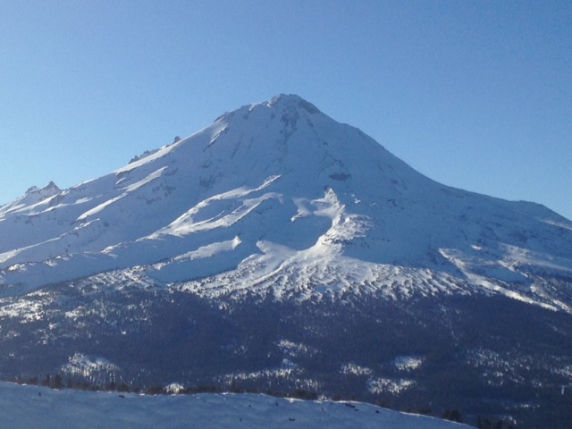
Adventures over the week brought in observations from Mt Shasta, Castle Lake, the Mt Eddy area, and Ash Creek Butte. Clear and cold weather has the snowpack in all these areas much the same....firm and variable. One will find the full 9 yards on any given piece of terrain: bullet proof ice, breakable crust, firm and chalky pack powder, melt runnels, and if your lucky or just good, a brief pocket of old powder. Snow depths are looking good however and we definitely have a solid base for the remaining winter. Mt Shasta and Ash Creek Butte are seeing average depths of 5 to 6 feet. In the Eddy Mountains, average snow depths are 3-4 feet in the Upper Deadfall Lakes area. Castle Lake and Cliff Lake snow depths are less, with an average of 1-3 feet.
Snow stability overall has been very good. It's been tough to even get a shovel in the snow in some areas. Lingering, small, hard wind slabs have been unreactive to trigger. Shallow snow on cold, northerly facing slopes is seeing some depth hoar (sugary, poorly bonded snow grains) form below a widespread, thick crust. Further loading from future snow could pose a threat for deep slab instability on these slopes, but not likely due to the thick crust layer(s). Elsewhere, cold, clear nights has formed well developed surface hoar crystals in lower elevation, protected areas. This could be our next weak layer if surface hoar persists and becomes buried....but with a week of sunny weather in the forecast, I suspect the surface hoar will be destroyed by sun and wind before our next storm. Icy surface conditions with new snow on top, whenever that may be, will pose the greatest threat for rising avalanche danger in the future. Avalanche danger will likely be in the form of storm and wind slabs on top of the icy bed surface and maybe, buried surface hoar.
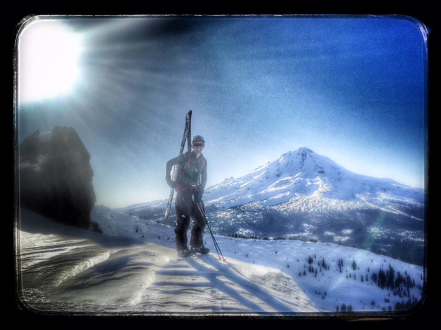
Below: East Bowl of Ash Creek Butte. A well known and large avalanche path and producer of frequent slides during storms and wind events. This slide observed on 1-1-15. It appeared to be a heat induced, wet sluff that probably occured during our rapid warming event on 12/20-12/21. Photo: Meyers
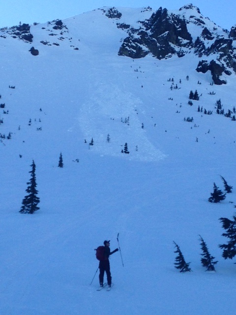
Above: Ash Creek Butte, 1-1-15 / Skier: Malee / Photo: Meyers
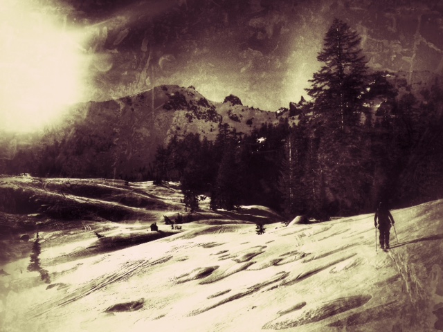
Above: East Side, 1.1.15 / Photo: Meyers
Report your observations to the MSAC! A photo, a few words... send them in! (nimeyers@fs.fed.us or 530-926-9614)
Castle Lake area has a shallow snowpack, but a few folks have been making some turns up there. Be careful of shallow buried objects. Ice skating was reported as "game on"... Cliff Lake is hosting poor skiing, but decent ice skating (back, lookers left portion of the lake is best) as well.
Sand Flat Winter Trails: OPEN and in good shape!
Pilgrim Creek Snowmobile Park: OPEN, however due to lack of low elevation snow, one must drive up the road several miles before enough snow is encountered. One CANNOT DRIVE over Military Pass. Don't try it, it just tears up the road for OSV users.
-------------------------------------------------------------------------------------------------------------------------------
Terrain: Remember most of the terrain that we like to play on is greater than 30 degrees. Avalanches are possible on anything steeper than 30 degrees. Avoid cornices, rock bands, terrain traps and runout zones of avalanche paths.
Weather: Most of our areas avalanche danger will occur 24-48 hours after a storm. We still can see persistent weak layers from time to time and we always will be sure to let you know about that! Heed the basic signs: Wind (significant snow transport and depositions), Temperature (rain/snow/rain/snow, which in turn weakens the snowpack), and Precipitation (Snow or rain add weight and stress to the current snowpack).
Snowpack: If snow accumulates, give the snowpack a chance to adjust to the new snow load before you play on or near steep slopes (greater than 30 degrees). Most direct action avalanches occur within 24-48 hours of recent snowfall. Watch for obvious signs of snowpack instability such as recent natural avalanche activity, collapsing of the snowpack (often associated with a “whumphing” sound), and shooting cracks. If you see these signs of instability, limit your recreation to lower angle slopes.
Human Factor: Don’t forget to carry and know how to use avalanche rescue gear. You should NOT be skiing or climbing potential avalanche slopes without having beacons, shovels, and probes. Only one person in a group should be exposed to potential avalanche danger at a time. Remember, climbing, skiing, and riding down the edge of slopes is safer than being in the center. Just because another person is on a slope doesn’t mean that it is safe. Be an individual! Make your own decisions. Heed the signs of instability: rapid warming, “whumphing” noises, shooting cracks, snowing an inch an hour or more, rain, roller balls, wind loading, recent avalanche activity.
The Five Red Flags of Avalanche Danger any time of year include: 1) Recent/current avalanche activity 2) Whumpfing sounds or shooting cracks 3) Recent/current heavy snowfall 4) Strong winds transporting snow 5) Rapid warming or rain on snow.
Weather and Current Conditions
Weather Summary
In Mt Shasta City this morning at 0500, we have a current temperature of 23 degrees, calm winds and clear skies.
WEATHER STATION INFORMATION (0500hrs):
On Mt Shasta (South Side) in the last 24 hours...
Old Ski Bowl - 7,600 feet, the current temperature is 34 F. Snow on the ground totals 64 inches with 5 inches settlement since last Sunday. We've had no new snow in the last 24 hours or over the week. Temperatures have ranged from 30 F to 44 F.
Gray Butte - 8,000 feet, winds have averaged 5-10 mph and variable in direction, with a max gust to 35 mph from the ENE. The current temperature is 34 F and temps have ranged from 32 F to 45 F in the last 24 hours.
Castle Lake and Mt Eddy (West side of Interstate-5)...
Castle Lake - 5,600 feet, the current temperature is 33 F. Temps have ranged from 26 F to 37 F in the last 24 hours. The Castle Lake area has some snow on the ground and a few brave souls have been sliding around on skis up there.
Mt Eddy - 6,500 feet, the current temperature is 34 F. Temps have ranged from 28 F to 42 F in the last 24 hours. Current snow depth is 24 inches with no new snow and 1 inch settlement over the week. Winds have averaged 2 mph and southerly in direction, with gusts to 11 mph, South.
WEATHER SYNOPSIS: All to familiar from last winter season, a high pressure ridge sits off the coast of California and continues to block any possibilities of wintery weather to our area. The result of this has been and will be clear weather and inversions for the next week or so. Warmer air has moved into the area at upper levels, however mixing will be minimal and thus inversions will be in place over the weekend. The general flow aloft remains northwest...wind speeds are mild this morning and today, but will gradually pick up to moderate (20-30 mph at 10,000 feet on Sat/Sun) as the weekend progresses. So... overall, not much winter action at this point... Longer range models show some breaking up of the blocking high pressure and normal to above normal precip for January in total. Lets keep the faith for that!
THIS SEASON: Since September 1st (the wet season) , we have received 22.08 inches of water, normal is 16.12 inches, putting us at 136% of normal. For the year of 2014, Mt Shasta finished off with 34.36 inches of water with normal being 43.21 inches, leaving us at 79% of normal for 2014. For December, Mt Shasta finished at 163% of normal, receiving 12.83 inches of water, normal is 7.85 inches. The area has not received any precipitation for January and/or 2015.
Always check the weather before you attempt to climb Mt Shasta. Further, monitor the weather as you climb. Becoming caught on the mountain in any type of weather can compromise life and limb. Be prepared.
| 0600 temperature: | 34 |
| Max. temperature in the last 24 hours: | 44 |
| Average wind direction during the last 24 hours: | Variable |
| Average wind speed during the last 24 hours: | 5-10 mi/hr |
| Maximum wind gust in the last 24 hours: | 35 mi/hr |
| New snowfall in the last 24 hours: | 0 inches |
| Total snow depth: | 64 inches |
Two Day Mountain Weather Forecast
Produced in partnership with the Medford NWS
| For 7000 ft to 9000 ft | |||
|---|---|---|---|
|
Friday (4 a.m. to 10 p.m.) |
Friday Night (10 p.m. to 4 a.m.) |
Saturday (4 a.m. to 10 p.m.) |
|
| Weather | Sunny | Clear | Sunny |
| Temperature (°F) | 41 | 28 | 44 |
| Wind (mi/hr) | North 5-10 mph | North 5-10 mph | Northwest 5-10 mph |
| Precipitation SWE / Snowfall (in) | / 0 | / 0 | / 0 |
| For 9000 ft to 11000 ft | |||
| Friday | Friday Night | Saturday | |
| Weather | Sunny | Clear | Sunny |
| Temperature (°F) | 37 | 20 | 35 |
| Wind (mi/hr) | North 5-10 mph | Northwest 0 | Northwest 10-15 mph, increasing in the afternoon |
| Precipitation SWE / Snowfall (in) | / 0 | / 0 | / 0 |

