

You are here
Avalanche Advisory for 2015-01-16 07:05:25
- EXPIRED ON January 17, 2015 @ 7:05 amPublished on January 16, 2015 @ 7:05 am
- Issued by Nick Meyers - Shasta-Trinity National Forest
Bottom Line
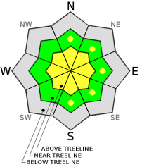
The avalanche danger remains LOW this morning and will increase to MODERATE as we move through the day for near and above treeline areas.
New storm snow (2-4 inches) and westerly winds (20-30mph) will allow for wind slab formation on N-NE-E-SE-S aspects, near and above treeline on our old, firm snow.
Terrain features such as ridgelines, convexities, rock outcrops, gullies, and extreme terrain should be most suspect. Wind slabs will be small to medium in size and stubborn to touchy to trigger.


Avalanche Problem 1: Wind Slab
-
Character ?

-
Aspect/Elevation ?
-
Likelihood ?CertainVery LikelyLikelyPossible
 Unlikely
 -
Size ?HistoricVery LargeLargeSmall

The current storm that has moved over the area last night and this morning is beginning to deposit measurable snow onto Mt Shasta. While new snow accumulation is only 1-2 inches right now, further snow accumulation and westerly wind will continue today.
Moderate to strong westerly winds will continue to blow today, 20-30mph with gusts higher. This will allow for snow transport and loading of leeward aspects. Near and above treeline, LOW danger this morning increasing to MODERATE avalanche danger this afternoon, will exist on N-NE-E-SE-S aspects. These aspects could host small to medium size wind slabs on top of old, firm snow. Said wind slabs could be stubborn to touchy to trigger. Above treeline areas in terrain features such as ridgelines, convexities, rock outcrops, gullies, and extreme terrain should be most suspect.
Wind slabs are often smooth and rounded and sometimes sound hollow, and can range from soft to hard. Avoid terrain with recent wind deposits or choose slopes gentler than 30 degrees in steepness. Test slopes, snow pits, slope cuts, previous tracks and cornice drops tend to provide some level of information on stability.
Avalanche Problem 2: Storm Slab
-
Character ?

-
Aspect/Elevation ?
-
Likelihood ?CertainVery LikelyLikelyPossible
Unlikely
-
Size ?HistoricVery LargeLargeSmall
Storm slabs are not a concern at this moment, though depending on how much new snow we get this weekend, storm slabs could become an avalanche problem. This type of avalanche involves the release of a soft, cohesive layer (slab) of new snow which breaks within the storm snow or on the old snow surface. Storm slabs are more prevalent at the higher elevations on all aspects. They tend to settle out and stabilize within a few days unless deposited on a persistent weak layer.
Recent Observations
Conditions over the week did not change much and while a few were able to find some warmer patches of corn snow during some warm spells, overall conditions remained firm and variable. On the upper mountain, while fairly smooth, the snow most definitely did not soften for folks venturing up there. Slide for life snow conditions still exist for the steeper slopes above treeline on Mt Shasta and climbers and skiers should be prepared for said conditions. A helmet, ice axe and crampons are recommended...and know how to use them (ie. self-arrest!)
Of most interest is the incoming/in process storm(s) for the area. We've got a firm and smooth bed surface for most of the forecast area right now. New snow totals over the weekend could accumulate to 6-8 inches near and above treeline. Westerly winds will give us a strong breeze to moderate gale at times. New snow and wind points to wind slab formation on leeward aspects....some uncertainty exists for how deep wind slabs will be and their sensitivity to trigger. This storm is on the warmer side, so I would expect new snow bonding to be good at lower and mid elevations. As one moves into mid and upper elevations (>9,000 feet), conditions will be different and the chance of triggering wind slabs greater. Precipitation and wind will occur all weekend and careful terrain selection will be important as wind slabs build.
Storm slabs are not a concern at this moment, though depending on how much new snow we get this weekend, storm slabs could become an avalanche problem. This type of avalanche involves the release of a soft, cohesive layer (slab) of new snow which breaks within the storm snow or on the old snow surface. Storm slabs are more prevalent at the higher elevations on all aspects. They tend to settle out and stabilize within a few days unless deposited on a persistent weak layer.
Report your observations to the MSAC! A photo, a few words... send them in! (nimeyers@fs.fed.us or 530-926-9614)
Castle Lake area has a shallow snowpack. Be careful of shallow buried objects. Skiing has been reported as poor to non-existent.
Sand Flat Winter Trails: OPEN
Pilgrim Creek Snowmobile Park: OPEN, however due to lack of low elevation snow, one must drive up the road several miles before enough snow is encountered. One CANNOT DRIVE over Military Pass.
-------------------------------------------------------------------------------------------------------------------------------
Terrain: Remember most of the terrain that we like to play on is greater than 30 degrees. Avalanches are possible on anything steeper than 30 degrees. Avoid cornices, rock bands, terrain traps and runout zones of avalanche paths.
Weather: Most of our areas avalanche danger will occur 24-48 hours after a storm. We still can see persistent weak layers from time to time and we always will be sure to let you know about that! Heed the basic signs: Wind (significant snow transport and depositions), Temperature (rain/snow/rain/snow, which in turn weakens the snowpack), and Precipitation (Snow or rain add weight and stress to the current snowpack).
Snowpack: If snow accumulates, give the snowpack a chance to adjust to the new snow load before you play on or near steep slopes (greater than 30 degrees). Most direct action avalanches occur within 24-48 hours of recent snowfall. Watch for obvious signs of snowpack instability such as recent natural avalanche activity, collapsing of the snowpack (often associated with a “whumphing” sound), and shooting cracks. If you see these signs of instability, limit your recreation to lower angle slopes.
Human Factor: Don’t forget to carry and know how to use avalanche rescue gear. You should NOT be skiing or climbing potential avalanche slopes without having beacons, shovels, and probes. Only one person in a group should be exposed to potential avalanche danger at a time. Remember, climbing, skiing, and riding down the edge of slopes is safer than being in the center. Just because another person is on a slope doesn’t mean that it is safe. Be an individual! Make your own decisions. Heed the signs of instability: rapid warming, “whumphing” noises, shooting cracks, snowing an inch an hour or more, rain, roller balls, wind loading, recent avalanche activity.
The Five Red Flags of Avalanche Danger any time of year include: 1) Recent/current avalanche activity 2) Whumpfing sounds or shooting cracks 3) Recent/current heavy snowfall 4) Strong winds transporting snow 5) Rapid warming or rain on snow.
Weather and Current Conditions
Weather Summary
In Mt Shasta City this morning at 0500, we have a current temperature of 39 degrees with a light breeze and rain.
WEATHER STATION INFORMATION (0500hrs):
On Mt Shasta (South Side) in the last 24 hours...
Old Ski Bowl - 7,600 feet, the current temperature is 26 F. Snow on the ground totals 62 inches with no settlement. The Old SKi Bowl weather station is recording 1-2 inches of new snow in the last 24 hours. We've received no new snow in the past week. Temperatures have ranged from 26 F to 32 F.
Gray Butte - 8,000 feet, winds have averaged 10-20 mph from the W, with a max gust to 42 mph from the WSW. The current temperature is 25 F and temps have ranged from 25 F to 30 F in the last 24 hours.
Castle Lake and Mt Eddy (West side of Interstate-5)...
Castle Lake - 5,600 feet, the current temperature is 30 F. Temps have ranged from 30 F to 38 F in the last 24 hours. The Castle Lake area has up to 2 feet of snow on the ground, but in general, less than that. Skiing is not happening up there currently.
Mt Eddy - 6,500 feet, the current temperature is 31 F. Temps have ranged from 30 F to 38 F in the last 24 hours. Current snow depth is 21 inches with 1-2 inches new snow and no settlement. Winds have averaged 1-3 mph and South in direction, with gusts to 13 mph from the SE.
WEATHER SYNOPSIS: While the storm doors are not being blown off their hinges, they are flapping in the wind and allowing some well received precipitation into the forecast area. This weekend will be wet and windy one. Here is the lowdown: The current storm track is westerly in nature and thus areas west of I-5 will tap most of the moisture out of the storm...that said, we are still looking at upwards of 1.21 inches of water forecasted to fall by the end of Sunday. Winds are going to gain strength tomorrow as a large jet streak extends out into the Pacific with wind speeds expected to reach 40-50 mph at the 10,000 foot level. Gusts and wind speeds could be higher (>50mph) in exposed areas and/or the upper mountain. Concerning the snow levels... it's going to be the same 'ol story unfortunatley - that is slightly warmer temps keeping freezing levels between 6,000 and 7,000 feet for most of the weekend. We may see some fluctuations higher, but not much lower than 6,000 feet. Regardless, it's nice to have some weather!
THIS SEASON: Since September 1st (the wet season) , we have received 22.12 inches of water, normal is 19.48 inches, putting us at 113% of normal. For January/2015, we've received 0.04 inches of water, normal is 3.60, putting us at 1% of normal. We're off to a rip-roarin' start!
Looking back into 2014, Mt Shasta finished off with 34.36 inches of water with normal being 43.21 inches, leaving us at 79% of normal for the year. For the month of December, Mt Shasta finished at 163% of normal, receiving 12.83 inches of water, normal is 7.85 inches.
Always check the weather before you attempt to climb Mt Shasta. Further, monitor the weather as you climb. Becoming caught on the mountain in any type of weather can compromise life and limb. Be prepared.
| 0600 temperature: | 26 |
| Max. temperature in the last 24 hours: | 32 |
| Average wind direction during the last 24 hours: | Westerly |
| Average wind speed during the last 24 hours: | 10-20 mi/hr |
| Maximum wind gust in the last 24 hours: | 42 mi/hr |
| New snowfall in the last 24 hours: | 1-2 inches |
| Total snow depth: | 62 inches |
Two Day Mountain Weather Forecast
Produced in partnership with the Medford NWS
| For 7000 ft to 9000 ft | |||
|---|---|---|---|
|
Friday (4 a.m. to 10 p.m.) |
Friday Night (10 p.m. to 4 a.m.) |
Saturday (4 a.m. to 10 p.m.) |
|
| Weather | Snow showers this morning, potentially switching to rain | Snow and rain | Rain and snow |
| Temperature (°F) | 40 | 33 | 43 |
| Wind (mi/hr) | South/Southwest Light to moderate breeze, 10-15mph | South/Southeast Light breeze, 5-10mph | South Light to moderate breeze, 5-15 mph |
| Precipitation SWE / Snowfall (in) | / 1-3 | / 1-2 | / 1-2 |
| For 9000 ft to 11000 ft | |||
| Friday | Friday Night | Saturday | |
| Weather | Snow | Snow likely | Snow |
| Temperature (°F) | 32 | 31 | 33 |
| Wind (mi/hr) | West Strong breeze, 20-30mph with gusts higher | Westerly 2-4 | West Moderate to fresh gale, 40-50mph |
| Precipitation SWE / Snowfall (in) | / 2-4 | / 1-3 | / 1-3 |

