

You are here
Avalanche Advisory for 2015-01-17 07:21:28
- EXPIRED ON January 18, 2015 @ 7:21 amPublished on January 17, 2015 @ 7:21 am
- Issued by Nick Meyers - Shasta-Trinity National Forest
Bottom Line
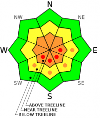
The avalanche danger will increase as one gains elevation on Mt Shasta today for wind slab avalanches on SW-S-SE-E facing slopes or where slabs are observed.
Below treeline, the danger is LOW. Near treeline the danger is MODERATE with pockets of CONSIDERABLE, above treeline (>8,300 feet) the danger is CONSIDERABLE. Pockets of HIGH avalanche danger, while not widespread, are possible later today at mid and upper mountain levels as more wind and snow add stress and weight to unstable wind slabs.


Avalanche Problem 1: Wind Slab
-
Character ?

-
Aspect/Elevation ?
-
Likelihood ?CertainVery LikelyLikelyPossible
 Unlikely
 -
Size ?HistoricVery LargeLargeSmall

Moderate to strong westerly winds will continue to blow today, 20-30mph with gusts higher above treeline. This will allow for further snow transport and loading of leeward aspects. The avalanche danger will increase as one gains elevation on the mountain. Near treeline, MODERATE danger will exist. As one gains elevation into above treeline terrain and above the freezing level, CONSIDERABLE avalanche danger will exist on SE-S-SE-E aspects. Areas of HIGH avalanche danger, while not widespread, may be possible as more snow and wind adds weight and stress to wind slabs and where the weak layer has preserved. These aspects could host small to large size wind slabs failing on a weak layer within the slab, 20-30 cm down from the top of the slab. Said wind slabs could be touchy to trigger. Above treeline areas in terrain features such as ridgelines, convexities, rock outcrops, gullies, and extreme terrain should be most suspect.
Wind slabs were found yesterday on southerly and easterly aspects up to 4 feet thick. Areas scoured down to the old snow are not of concern.
Wind slabs are often smooth and rounded and sometimes sound hollow, and can range from soft to hard. Avoid terrain with recent wind deposits or choose slopes gentler than 30 degrees in steepness. Test slopes, snow pits, slope cuts, previous tracks and cornice drops tend to provide some level of information on stability.
Recent Observations
Mt Shasta has seen a couple weeks of high and dry weather for the most part up until late Thursday night and Friday morning (1-15/1-16). Early Friday morning is when the first wave of weather came through the area with a decent dollop of snow and moderate to strong westerly winds. Snow levels made it all the way down to McBride Springs along the Everitt Memorial Hwy (approx. 5,000 feet), but measureable snow wasn't found until about 6,000 feet. Once one was above Bunny Flat and near and/or above treeline, about 6 inches of new snow was recorded at the Old SKi Bowl Weather Station, treeline, 7,800 feet. This measurement was confirmed from personal observation. Venturing around the Old Ski Bowl and from reports from Avalanche Gulch, there was a lot of spacial variability for new snow amounts. Some areas remained scoured due to westerly winds, and other areas hosted new snow/wind slabs up to several feet thick, depending on elevation, aspect and orientation to the wind. Let's talk about those wind slabs...
Yesterday, we experienced above freezing temperatures below 8,300 feet and this created a 1-2 cm temperature crust on the top of the snowpack. This will likely present itself in the form of a thin, breakable zipper crust for most areas below said elevation today. Avalanche danger below treeline, below the freezing level mentioned, will be low today.
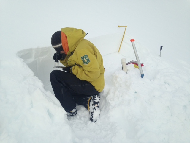
At 1500 hours, a full pit dug at 8,300 feet, southeast facing and 30 degrees resulted in a 49cm wind slab on top of the old, firm snow. Numerous ECTX (No fracture occurs during the test) were achieved at this pit location. We were a bit confused at these seemingly stable results as we had just spoke with a skier at Bunny Flat who had observed an avalanche off of Casaval Ridge (approx. 9,000 feet) during his tour in Avalanche Gulch, not an hour or two earlier. This same skier also conducted ECT tests and received failure on a weak layer within the new snow upon isolation. What were we missing?
We were not satisfied with these results and decided to gain a bit of elevation and dig again. At another southeast facing slope only 300 vertical feet higher (8,600 feet) we conducted several more ECT and CT tests and the avalanche problem reared its head. Two ECT tests resulted in ECTP2 and ECTN5 at a weak layer 20-25 cm down from the surface of the snowpack. This means that one test we had full propagation across the column and the other test we did not have propagation across the column. Both tests, fracture was easily initiated. Closer investigation revealed the weak layer to appear to be some buried surface hoar, or light and feathery snow crystals. This weak layer is what the observed slide off Casaval Ridge slid on. It was in this elevation change above the freezing level (approx. 8,300 to 8,400 feet) that the weak layer preserved itself and instability was found. For today, areas that have remained below freezing (mid and upper mountain)... it's likely that this weak layer has preserved itself and further instabilities will likely be encountered where wind slabs are found.
New snow/wind slab bonding to the old snow surface, just of note, was good. We were able to initiate fracture at this layer with hard, sustained pressure conducting shovel shear tests, but all other tests gave no results with this layer. This interface is of less concern.
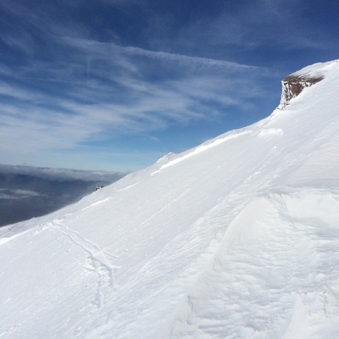
Below: Avalanche off of Casaval Ridge, sliding into Avalanche Gulch, 1.16.15 / Pole buried in thick wind slab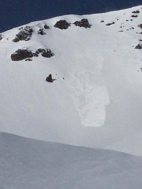
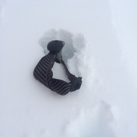
A small, skier triggered slide occured in Powder Bowl yesterday near the noon hour. The avalanche slid on the same weak layer noted above. Extended column tests from this group on the very top slope of Powder Bowl also noted easy failures. Other observations from the group reported wind slabs 4 feet thick! (see pole photo above) This is accurate as we also noted 1-4 foot thick wind slabs on primarily S-SE-E facing aspects, near and above treeline.
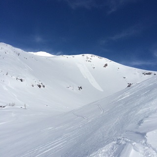
Below, left to right: Powder Bowl Slide / Powder Bowl crown with skiers skin track across starting zone
What does all this mean? A few red flags are popping up within the past few days: new snow, westerly wind, recent avalanche activity, more snow and wind in the forecast, warming temperatures. The freezing level on the mountain will dictate sensitivity to triggering of wind slabs. Above the freezing level, slabs could be sensitive to trigger. Below the freezing level, the snowpack seems to have settled and created stubborn sensitivity to triggering of wind slabs. Some areas on the mountain continue to be scoured to our old snow and these areas are not a concern, other than a slide for life! The concern lies for wind slabs on southerly and easterly slopes, above 8,300 feet, where the weak layer has preserved within the top layers of the snowpack. Slightly warming temperatures could increase sensitivity to triggering, as well as more new snow and wind adding weight and stress to wind slabs. Be careful out there!
Below: Jon Dove getting down to business
Report your observations to the MSAC! A photo, a few words... send them in! (nimeyers@fs.fed.us or 530-926-9614)
Castle Lake area has a shallow snowpack. Be careful of shallow buried objects. Skiing has been reported as poor to non-existent.
Sand Flat Winter Trails: OPEN
Pilgrim Creek Snowmobile Park: OPEN, however due to lack of low elevation snow, one must drive up the road several miles before enough snow is encountered. One CANNOT DRIVE over Military Pass.
-------------------------------------------------------------------------------------------------------------------------------
Terrain: Remember most of the terrain that we like to play on is greater than 30 degrees. Avalanches are possible on anything steeper than 30 degrees. Avoid cornices, rock bands, terrain traps and runout zones of avalanche paths.
Weather: Most of our areas avalanche danger will occur 24-48 hours after a storm. We still can see persistent weak layers from time to time and we always will be sure to let you know about that! Heed the basic signs: Wind (significant snow transport and depositions), Temperature (rain/snow/rain/snow, which in turn weakens the snowpack), and Precipitation (Snow or rain add weight and stress to the current snowpack).
Snowpack: If snow accumulates, give the snowpack a chance to adjust to the new snow load before you play on or near steep slopes (greater than 30 degrees). Most direct action avalanches occur within 24-48 hours of recent snowfall. Watch for obvious signs of snowpack instability such as recent natural avalanche activity, collapsing of the snowpack (often associated with a “whumphing” sound), and shooting cracks. If you see these signs of instability, limit your recreation to lower angle slopes.
Human Factor: Don’t forget to carry and know how to use avalanche rescue gear. You should NOT be skiing or climbing potential avalanche slopes without having beacons, shovels, and probes. Only one person in a group should be exposed to potential avalanche danger at a time. Remember, climbing, skiing, and riding down the edge of slopes is safer than being in the center. Just because another person is on a slope doesn’t mean that it is safe. Be an individual! Make your own decisions. Heed the signs of instability: rapid warming, “whumphing” noises, shooting cracks, snowing an inch an hour or more, rain, roller balls, wind loading, recent avalanche activity.
The Five Red Flags of Avalanche Danger any time of year include: 1) Recent/current avalanche activity 2) Whumpfing sounds or shooting cracks 3) Recent/current heavy snowfall 4) Strong winds transporting snow 5) Rapid warming or rain on snow.
Weather and Current Conditions
Weather Summary
In Mt Shasta City this morning at 0500, we have a current temperature of 42 degrees, 3 degrees warmer than yesterday at this time, with cloudy skies and areas of fog.
WEATHER STATION INFORMATION (0500hrs):
On Mt Shasta (South Side) in the last 24 hours...
Old Ski Bowl - 7,600 feet, the current temperature is 32 F. Snow on the ground totals 72 inches with no settlement. The Old SKi Bowl weather station is recording 1 inch of new snow in the last 24 hours. Storm total (since late Thursday night/Friday morning) is 6-8 inches . Temperatures have ranged from 24 F to 33 F.
Gray Butte - 8,000 feet, winds have averaged 12 mph from the WNW, with a max gust to 21 mph from the WNW. The current temperature is 31 F and temps have ranged from 24 F to 32 F in the last 24 hours.
Castle Lake and Mt Eddy (West side of Interstate-5)...
Castle Lake - 5,600 feet, the current temperature is 38 F. Temps have ranged from 30 F to 40 F in the last 24 hours. New snow totals 4-6 inches since Friday morning (new storm snow). The Castle Lake area has up to 2 feet of snow on the ground.
Mt Eddy - 6,500 feet, the current temperature is 35 F. Temps have ranged from 30 F to 40 F in the last 24 hours. Current snow depth is 26 inches with 1 inch new snow and a storm total of 6 inches and little settlement. Winds have averaged 2 mph and South in direction, with gusts to 7 mph from the WSW.
WEATHER SYNOPSIS: The next wave of weather this weekend is moving on shore and while not a drencher, it will bring more welcomed precip to the forecast area. Flow remains westerly nature with the storm center situated north of us mostly. Mt Shasta will get the southern edge of the storm.... so, we won't remain high and dry, but we also won't get a super soaker. With this next wave, temperatures are going to rise a couple degrees and we are already seeing that reflected off weather station information this morning. This rise in temperature will raise snow levels a tad today, but colder air is close behind and will cool us back down... of course after the storm passes on Sunday and Monday.
Today, we are looking at snow levels to sit right around 7,000 to 8,000 feet, mabye a touch higher for a brief period. Precipitation totals will be near .4 inches of water which could mean another several inches of snow at mid and upper mountain levels. We should see upwards of .5 inches of water and as much as .62 inches by the end of the storm on Sunday evening. Winds will remain light to moderate below treeline, however near and above treeline WNW winds will reach their zenith today, subside tomorrow and calm back down by Monday. Wind at the 10,000 foot level is forecasted to blow 30-40 mph with gusts higher, westerly in nature.
THIS SEASON: Since September 1st (the wet season) , we have received 22.45 inches of water, normal is 19.71 inches, putting us at 113% of normal. For January/2015, we've received 0.37 inches of water, normal is 3.83, putting us at 9% of normal.
Looking back into 2014, Mt Shasta finished off with 34.36 inches of water with normal being 43.21 inches, leaving us at 79% of normal for the year. For the month of December, Mt Shasta finished at 163% of normal, receiving 12.83 inches of water, normal is 7.85 inches.
Always check the weather before you attempt to climb Mt Shasta. Further, monitor the weather as you climb. Becoming caught on the mountain in any type of weather can compromise life and limb. Be prepared.
| 0600 temperature: | 32 |
| Max. temperature in the last 24 hours: | 33 |
| Average wind direction during the last 24 hours: | WNW |
| Average wind speed during the last 24 hours: | 12 mi/hr |
| Maximum wind gust in the last 24 hours: | 21 mi/hr |
| New snowfall in the last 24 hours: | 6-8 inches |
| Total snow depth: | 72 inches |
Two Day Mountain Weather Forecast
Produced in partnership with the Medford NWS
| For 7000 ft to 9000 ft | |||
|---|---|---|---|
|
Saturday (4 a.m. to 10 p.m.) |
Saturday Night (10 p.m. to 4 a.m.) |
Sunday (4 a.m. to 10 p.m.) |
|
| Weather | Rain likely this morning and this afternoon | Rain and snow | Rain and snow |
| Temperature (°F) | 42 | 33 | 46 |
| Wind (mi/hr) | South/Southwest Moderate wind, 10-20 mph | South/Soutwest Light to moderate wind, 10-15mph | Southwest A fresh wind, 15-25 mph |
| Precipitation SWE / Snowfall (in) | / .25 in h20 | / .25 in h20 | / .20 in h20 |
| For 9000 ft to 11000 ft | |||
| Saturday | Saturday Night | Sunday | |
| Weather | Snow | Snow | Snow |
| Temperature (°F) | 33 | 21 | 29 |
| Wind (mi/hr) | West Near gale force winds, 40-50 mph | Westerly 2-4 | West Strong wind, 20-30mph |
| Precipitation SWE / Snowfall (in) | / 2-4 | / 3-5 | / 1-3 |

