

You are here
Avalanche Advisory for 2015-01-18 06:54:47
- EXPIRED ON January 19, 2015 @ 6:54 amPublished on January 18, 2015 @ 6:54 am
- Issued by Nick Meyers - Shasta-Trinity National Forest
Bottom Line
Concern remains today for areas of sensitive, unstable wind slabs above 9,500 feet on Mt Shasta.
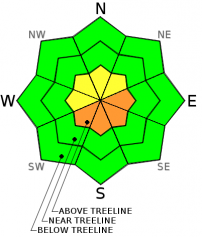
CONSIDERABLE avalanche danger could be found on SW-S-SE-E facing aspects or where wind slabs are observed. Slabs could be 1-4 feet thick, small to large.
LOW avalanche danger will exist for all aspects below and near treeline


Avalanche Problem 1: Wind Slab
-
Character ?

-
Aspect/Elevation ?
-
Likelihood ?CertainVery LikelyLikelyPossible
 Unlikely
 -
Size ?HistoricVery LargeLargeSmall

Rain/mist has destroyed weak layers in the snowpack yesterday for all areas below the freezing level, that is approximately 9,500 feet and lower. Concern remains for existing wind slabs on all associated aspects, south to east, on the upper mountain. Isolated areas where slabs are present, CONSIDERABLE avalanche danger will exist and slabs could still be sensitive to trigger and unstable.
Wind slabs could be 1-4 feet thick, small to large in size. Give these upper mountain areas a couple more days to stabilize before adventuring up higher. The avalanche danger will improve over the next few days.
Wind slabs are often smooth and rounded and sometimes sound hollow, and can range from soft to hard. Avoid terrain with recent wind deposits or choose slopes gentler than 30 degrees in steepness. Test slopes, snow pits, slope cuts, previous tracks and cornice drops tend to provide some level of information on stability.
Recent Observations
Narrative for 1-18-15: Oh, the weather, what a pity it has been in the last 24 hours. Big smiles were floating around as folks made it off the mountain on Friday. Winter stoke was rejuvinated from the first storm wave that came in on late Thursday and Friday depositing a decent 6 inches of fresh snow on the mountain. Then there was Saturday... we knew it was going to get warmer, but sheesh, not that warm. Hopes of fresh-n-smooth snow, winter, good skiing and all the intrinsic things that come with said conditions were squashed, literally yesterday as heavy mist and rain fell from the sky and water flowed off any receiving surface. The Old Ski Bowl tipping bucket recorded .37 inches of water in the last 24 hours and snow settlement near 4 inches. Temps at 8,000 feet dropped no lower than 32 degrees and for most of the day stuck right around 36 degrees. This means that snow/freezing levels were probably near the 9,000 to 9,500 foot level.
Visibility was extremely poor yesterday. I was dying to see what kind of avalanche activity was going on above treeline with our current weak layer within newly formed wind slabs, but that didn't happen. I would make a decent bet that the rapid warming and rain on snow likely caused some slides to occur above treeline that we couldn't see. I'm looking forward to the clouds parting and revealing the possible action.
Per the narrative from yesterday, there was discussion about a weak layer (buried surface hoar/light feathery crystals) within newly formed wind slabs, 20-30 cm down from the top of slabs. Friday, easy failures (ECTP2 and ECTN5 in Old Ski Bowl, similar results reported from skiers in Avalanche Gulch) and natural and skier triggered avalanche activity was observed and concern was stated for wind loaded aspects above 8,300 feet. Any avalanche activity that occured was likely direct action and probably already happened during the warm up/rain of yesterday. That said, I still have concern for all areas above the rain/snow level on Mt Shasta. Rain/mist destroyed weak layers yesterday at and below the freezing level, so today I'd bump up the area of concern to 9,500 feet and above. All other areas, Mt Eddy, Castle Lake, received rain on snow and experienced up to 6 inches settlement in the snowpack.
So, backcountry concern will stay focused on wind slabs on S-SE-E aspects at mid and upper mountain levels. The weak layer within slabs that we were getting easy failures on (friday) was destroyed yesterday by rain/mist, but at upper elevations, could still be preserved. If the conditions that we found on Friday have been preserved above the rain/snow line, we could still have isolated areas of sensitive, unstable wind slabs. I would give these slabs another couple days to settle out before venturing onto the steeper slopes of the upper mountain.
Narrative below from 1-17-15 Advisory: Mt Shasta has seen a couple weeks of high and dry weather for the most part up until late Thursday night and Friday morning (1-15/1-16). Early Friday morning is when the first wave of weather came through the area with a decent dollop of snow and moderate to strong westerly winds. Snow levels made it all the way down to McBride Springs along the Everitt Memorial Hwy (approx. 5,000 feet), but measureable snow wasn't found until about 6,000 feet. Once one was above Bunny Flat and near and/or above treeline, about 6 inches of new snow was recorded at the Old SKi Bowl Weather Station, treeline, 7,800 feet. This measurement was confirmed from personal observation. Venturing around the Old Ski Bowl and from reports from Avalanche Gulch, there was a lot of spacial variability for new snow amounts. Some areas remained scoured due to westerly winds, and other areas hosted new snow/wind slabs up to several feet thick, depending on elevation, aspect and orientation to the wind. Let's talk about those wind slabs...
Friday, we experienced above freezing temperatures below 8,300 feet and this created a 1-2 cm temperature crust on the top of the snowpack. This will likely present itself in the form of a thin, breakable zipper crust for most areas below said elevation. Avalanche danger below treeline, below the freezing level mentioned, will be low.
At 1500 hours, a full pit dug at 8,300 feet, southeast facing and 30 degrees resulted in a 49cm wind slab on top of the old, firm snow. Numerous ECTX (No fracture occurs during the test) were achieved at this pit location. We were a bit confused at these seemingly stable results as we had just spoke with a skier at Bunny Flat who had observed an avalanche off of Casaval Ridge (approx. 9,000 feet) during his tour in Avalanche Gulch, not an hour or two earlier. This same skier also conducted ECT tests and received failure on a weak layer within the new snow upon isolation. What were we missing?
We were not satisfied with these results and decided to gain a bit of elevation and dig again. At another southeast facing slope only 300 vertical feet higher (8,600 feet) we conducted several more ECT and CT tests and the avalanche problem reared its head. Two ECT tests resulted in ECTP2 and ECTN5 at a weak layer 20-25 cm down from the surface of the snowpack. This means that one test we had full propagation across the column and the other test we did not have propagation across the column. Both tests, fracture was easily initiated. Closer investigation revealed the weak layer to appear to be some buried surface hoar, or light and feathery snow crystals. This weak layer is what the observed slide off Casaval Ridge slid on. It was in this elevation change above the freezing level (approx. 8,300 to 8,400 feet) that the weak layer preserved itself and instability was found. For today, areas that have remained below freezing (mid and upper mountain)... it's likely that this weak layer has preserved itself and further instabilities will likely be encountered where wind slabs are found.
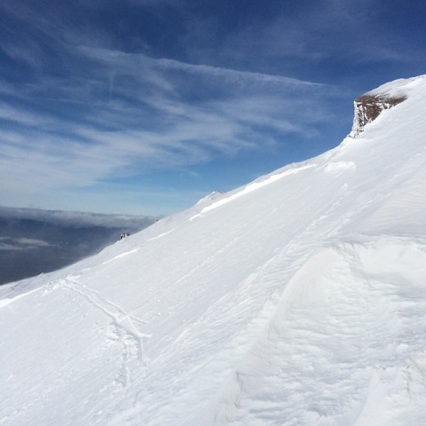
Below: Avalanche off of Casaval Ridge, sliding into Avalanche Gulch, 1.16.15 / Pole buried in thick wind slab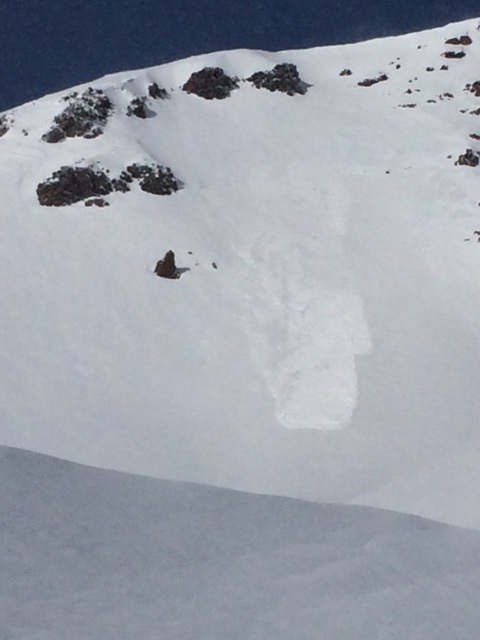
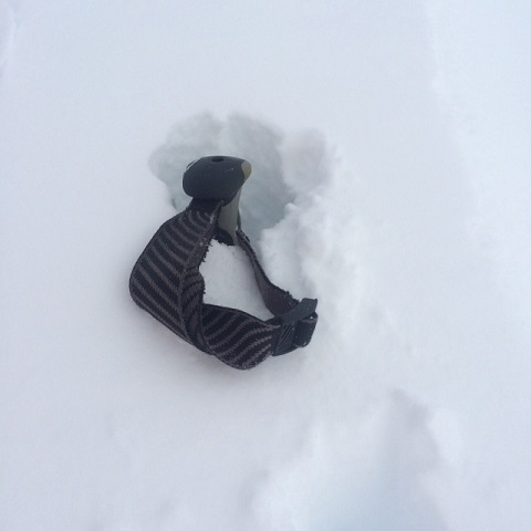
A small, skier triggered slide occured in Powder Bowl near the noon hour on 1-16-15. The avalanche slid on the same weak layer noted above. Extended column tests from this group on the very top slope of Powder Bowl also noted easy failures. Other observations from the group reported wind slabs 4 feet thick! (see pole photo above) This is accurate as we also noted 1-4 foot thick wind slabs on primarily S-SE-E facing aspects, near and above treeline.
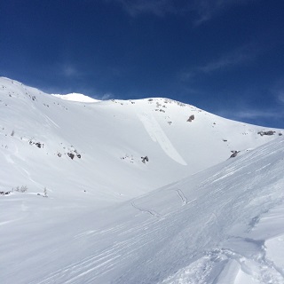
Below, left to right: Powder Bowl Slide / Powder Bowl crown with skiers skin track across starting zone
A few red flags are popping up within the past few days: new snow, westerly wind, recent avalanche activity, warming temperatures. The freezing level on the mountain will dictate sensitivity to triggering of wind slabs. Above the freezing level, slabs could be sensitive to trigger. Below the freezing level, the snowpack seems to have settled and created stubborn sensitivity to triggering of wind slabs. Some areas on the mountain continue to be scoured to our old snow and these areas are not a concern, other than a slide for life! The concern lies for wind slabs on southerly and easterly slopes, where the weak layer has preserved within the top layers of the snowpack.
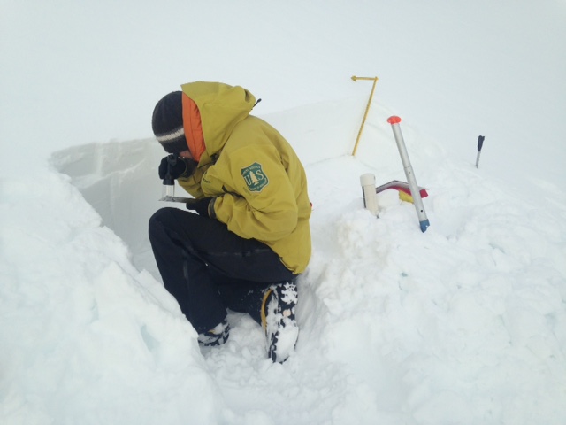
Below: Jon Dove getting down to business
Report your observations to the MSAC! A photo, a few words... send them in! (nimeyers@fs.fed.us or 530-926-9614)
Castle Lake area has a shallow snowpack. Be careful of shallow buried objects. Skiing has been reported as poor to non-existent.
Sand Flat Winter Trails: OPEN
Pilgrim Creek Snowmobile Park: OPEN, however due to lack of low elevation snow, one must drive up the road several miles before enough snow is encountered. One CANNOT DRIVE over Military Pass.
-------------------------------------------------------------------------------------------------------------------------------
Terrain: Remember most of the terrain that we like to play on is greater than 30 degrees. Avalanches are possible on anything steeper than 30 degrees. Avoid cornices, rock bands, terrain traps and runout zones of avalanche paths.
Weather: Most of our areas avalanche danger will occur 24-48 hours after a storm. We still can see persistent weak layers from time to time and we always will be sure to let you know about that! Heed the basic signs: Wind (significant snow transport and depositions), Temperature (rain/snow/rain/snow, which in turn weakens the snowpack), and Precipitation (Snow or rain add weight and stress to the current snowpack).
Snowpack: If snow accumulates, give the snowpack a chance to adjust to the new snow load before you play on or near steep slopes (greater than 30 degrees). Most direct action avalanches occur within 24-48 hours of recent snowfall. Watch for obvious signs of snowpack instability such as recent natural avalanche activity, collapsing of the snowpack (often associated with a “whumphing” sound), and shooting cracks. If you see these signs of instability, limit your recreation to lower angle slopes.
Human Factor: Don’t forget to carry and know how to use avalanche rescue gear. You should NOT be skiing or climbing potential avalanche slopes without having beacons, shovels, and probes. Only one person in a group should be exposed to potential avalanche danger at a time. Remember, climbing, skiing, and riding down the edge of slopes is safer than being in the center. Just because another person is on a slope doesn’t mean that it is safe. Be an individual! Make your own decisions. Heed the signs of instability: rapid warming, “whumphing” noises, shooting cracks, snowing an inch an hour or more, rain, roller balls, wind loading, recent avalanche activity.
The Five Red Flags of Avalanche Danger any time of year include: 1) Recent/current avalanche activity 2) Whumpfing sounds or shooting cracks 3) Recent/current heavy snowfall 4) Strong winds transporting snow 5) Rapid warming or rain on snow.
Weather and Current Conditions
Weather Summary
In Mt Shasta City this morning at 0500, we have a current temperature of 46 degrees, 4 degrees warmer than yesterday at this time, with cloudy skies and light rain.
WEATHER STATION INFORMATION (0500hrs):
On Mt Shasta (South Side) in the last 24 hours...
Old Ski Bowl - 7,600 feet, the current temperature is 32 F. Snow on the ground totals 69 inches with 3-4 inches settlement. The Old Ski Bowl weather station has no new snow but did receive .37 inches water (rain) in the last 24 hours. Temperatures have ranged from 32 F to 37 F.
Gray Butte - 8,000 feet, winds have averaged 20 mph from the W, with a max gust to 35 mph from the WSW. The current temperature is 32 F and temps have ranged from 32 F to 36 F in the last 24 hours.
Castle Lake and Mt Eddy (West side of Interstate-5)...
Castle Lake - 5,600 feet, the current temperature is 37 F. Temps have ranged from 37 F to 47 F in the last 24 hours. The Castle Lake area has up to 2 feet of snow on the ground, no new snow in the last 24 hours and only rain.
Mt Eddy - 6,500 feet, the current temperature is 37 F. Temps have ranged from 37 F to 47 F in the last 24 hours. Current snow depth is 19 inches with no new snow and 6 inches settlement. Winds have averaged 2 mph and South in direction, with gusts to 15 mph from the S.
WEATHER SYNOPSIS: We will see some lingering, post frontal showers today with continued high snow levels in the 7,000 to 8,000 foot range, maybe higher, though temps should cool a bit. Models show .15 inches more of water expected Sunday. Winds have been moderate with stronger gusts occasionally, all westerly in nature. Westerly winds will subside and the area will make a move back towards clear skies, high pressure and overall more nice weather for the work week. So, nothing major to note... diminishing precipitation, wind and clouds. Have a great week!
THIS SEASON: Since September 1st (the wet season) , we have received 22.47 inches of water, normal is 19.93 inches, putting us at 112% of normal. For January/2015, we've received 0.39 inches of water, normal is 4.05, putting us at 9% of normal.
Looking back into 2014, Mt Shasta finished off with 34.36 inches of water with normal being 43.21 inches, leaving us at 79% of normal for the year. For the month of December, Mt Shasta finished at 163% of normal, receiving 12.83 inches of water, normal is 7.85 inches.
Always check the weather before you attempt to climb Mt Shasta. Further, monitor the weather as you climb. Becoming caught on the mountain in any type of weather can compromise life and limb. Be prepared.
| 0600 temperature: | 32 |
| Max. temperature in the last 24 hours: | 37 |
| Average wind direction during the last 24 hours: | Westerly |
| Average wind speed during the last 24 hours: | 20 mi/hr |
| Maximum wind gust in the last 24 hours: | 35 mi/hr |
| New snowfall in the last 24 hours: | 0 inches |
| Total snow depth: | 69 inches |
Two Day Mountain Weather Forecast
Produced in partnership with the Medford NWS
| For 7000 ft to 9000 ft | |||
|---|---|---|---|
|
Sunday (4 a.m. to 10 p.m.) |
Sunday Night (10 p.m. to 4 a.m.) |
Monday (4 a.m. to 10 p.m.) |
|
| Weather | Lingering rain showers, clearing trend in the PM | Partly cloudy | Sunny |
| Temperature (°F) | 43 | 25 | 40 |
| Wind (mi/hr) | Southwest 20-25 mph decreasing in the PM | West 5-10 mph | Northwest 0-5 mph |
| Precipitation SWE / Snowfall (in) | / .15" rain | / 0 | / 0 |
| For 9000 ft to 11000 ft | |||
| Sunday | Sunday Night | Monday | |
| Weather | Lingering snow showers | Lingering snow showers, 20% chance | Sunny |
| Temperature (°F) | 29 | 16 | 33 |
| Wind (mi/hr) | West 30-40 mph | Westerly 1-2 | West/Northwest 5-10 mph |
| Precipitation SWE / Snowfall (in) | / 1-2 | / 0 - 1" | / 0 |

