

You are here
Avalanche Advisory for 2015-01-31 06:49:10
- EXPIRED ON February 1, 2015 @ 6:49 amPublished on January 31, 2015 @ 6:49 am
- Issued by Nick Meyers - Shasta-Trinity National Forest
Bottom Line
The overall avalanche danger is LOW for the forecast area. Carry a beacon, shovel and probe.
Other hazards include: Icefall off exposed rocks onto climbers/skiers below, and smooth, firm snow on the upper mountain creating 'slide-for-life' conditions. Immediate self-arrest skills are mandatory should one slip and fall.
Know how to use all your equipment!


Avalanche Problem 1: Normal Caution
-
Character ?

-
Aspect/Elevation ?
-
Likelihood ?CertainVery LikelyLikelyPossible
 Unlikely
 -
Size ?HistoricVery LargeLargeSmall

Overall, LOW avalanche danger exists in the forecast area. Carry a beacon, shovel and probe and know how to use this equipment.
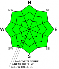
Photo: A beauty from yesterday: Sunset ski in Powder Bowl - Photo: S Stem
Recent Observations
Same same, but different! Knowbody is deficit of vitamin D this January, granted you've been out enjoying some of this beautiful sun shining down upon Northern California. Chris Carr of Shasta Mountain Guides said it well, "It's hard to complain with mild temps and smooth, sun softened corn snow, but this is the time of year for frozen fingers and raging wood stoves!" Yes indeed. While it's easy to jump to conclusions like, "...winter is over", we still have two full precipitable months and I'm resting faith. Nicholas Sparks said from A Walk to Remember, "I don't think that we're meant to understand it all the time. I think that sometimes we just have to have faith."
Last call for generous servings of corn! One more day of sun, corn snow and clear skies before we begin to enter the beginning of a stormy week. Clouds will enter the area tomorrow and bring some light precip to the area for the start of the work week. More to come on the extent of this storm in tomorrows advisory.
As of late, the skiing and riding have been excellent over the last week as sunny skies, and relatively warm daytime temperatures have kept the melt/freeze cycle working well. Per standard corn skiing protocol... elevation, aspect, time of day, 24 hour high and low temps and clouds/wind will all factor when and where the best skiing will be. In general, low to mid elevation slopes E-SE-S facing during the early to mid afternoon are best! All this corn ski fun and sun will come to a temporary rest as stormy weather crescendos beginning tomorrow and over the week.
We've been hard pressed to find any signs of instability for over a week now here at the MSAC. Even with our very warm spell last weekend, we had zero observed loose/wet roller balls and/or point release instabilities on slopes accessible from Bunny Flat trailhead. Pit profiles and stability tests have confirmed our strong, isothermal (equal temperature) snowpack and in general we've measured 68 inches near treeline on Mt Shasta (7,600-7,900 feet). This will provide a great base for the second half of winter.
Climbing conditions have been very good, however take note: climbers headed onto the upper mountain will find smooth and firm snow surface conditions presenting the possibility for "slide for life" incidents... while snow surface conditions as such provide for great climbing, it also ups the ante should one fall. It goes without saying, but bring your crampons, helmet, and ice axe and WEAR A HELMET! Rime and water ice plastered on exposed rocks has been flaking off and falling onto climbers below. Keep your head up and watch for this hazard, especially on the Avalanche Gulch route above Lake Helen. No instabilities have been observed or recorded on the upper mountain.
To summarize, concerns for skiing and climbing on Shasta will be: 1) Rime and water ice melting/flaking off exposed rocks and falling onto one below 2) Smooth and firm upper mountain conditions posing the threat for a slide for life should one slip and fall.
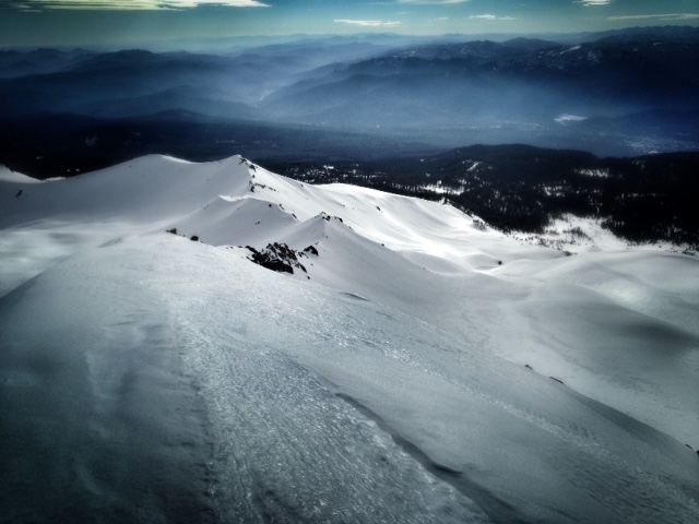
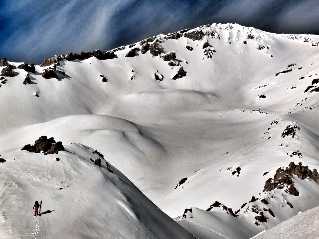
Top row, left to right: Skier ascends the upper ramparts of Powder/Sun Bowl - Photo: J Dove / Green Butte Ridge, 10,000 feet, looking south - Photo: N Meyers
Middle row: Nick Meyers and Jon Dove help set up for the recent Shasta Ascension Backcountry Ski Race in The Old Ski Bowl - Photo: G Beck
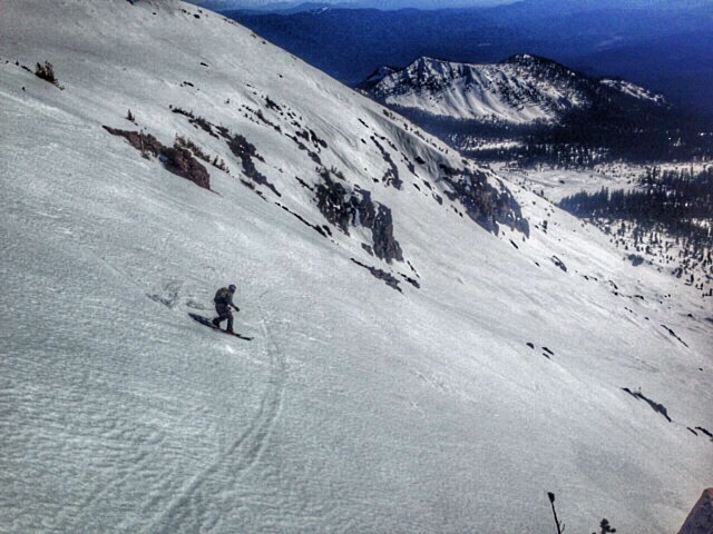
Bottom row: Powder Bowl shredder - Photo: J Dove / Green Butte Ridge and Avalanche Gulch - Photo: S Rathbun
(All photos from within the last week)
Report your observations to the MSAC! A photo, a few words... send them in! (nimeyers@fs.fed.us or 530-926-9614)
Castle Lake area has a shallow snowpack. Be careful of shallow buried objects. Skiing has been reported as poor to non-existent.
Sand Flat Winter Trails: OPEN, trail conditions are firm and getting thin with some tree debris on snow surface.
Pilgrim Creek Snowmobile Park: OPEN, however due to lack of low elevation snow, one must drive up the road several miles before enough snow is encountered. One CANNOT DRIVE over Military Pass.
-------------------------------------------------------------------------------------------------------------------------------
Terrain: Remember most of the terrain that we like to play on is greater than 30 degrees. Avalanches are possible on anything steeper than 30 degrees. Avoid cornices, rock bands, terrain traps and runout zones of avalanche paths.
Weather: Most of our areas avalanche danger will occur 24-48 hours after a storm. We still can see persistent weak layers from time to time and we always will be sure to let you know about that! Heed the basic signs: Wind (significant snow transport and depositions), Temperature (rain/snow/rain/snow, which in turn weakens the snowpack), and Precipitation (Snow or rain add weight and stress to the current snowpack).
Snowpack: If snow accumulates, give the snowpack a chance to adjust to the new snow load before you play on or near steep slopes (greater than 30 degrees). Most direct action avalanches occur within 24-48 hours of recent snowfall. Watch for obvious signs of snowpack instability such as recent natural avalanche activity, collapsing of the snowpack (often associated with a “whumphing” sound), and shooting cracks. If you see these signs of instability, limit your recreation to lower angle slopes.
Human Factor: Don’t forget to carry and know how to use avalanche rescue gear. You should NOT be skiing or climbing potential avalanche slopes without having beacons, shovels, and probes. Only one person in a group should be exposed to potential avalanche danger at a time. Remember, climbing, skiing, and riding down the edge of slopes is safer than being in the center. Just because another person is on a slope doesn’t mean that it is safe. Be an individual! Make your own decisions. Heed the signs of instability: rapid warming, “whumphing” noises, shooting cracks, snowing an inch an hour or more, rain, roller balls, wind loading, recent avalanche activity.
The Five Red Flags of Avalanche Danger any time of year include: 1) Recent/current avalanche activity 2) Whumpfing sounds or shooting cracks 3) Recent/current heavy snowfall 4) Strong winds transporting snow 5) Rapid warming or rain on snow.
Weather and Current Conditions
Weather Summary
In Mt Shasta City this morning at 0500, we have a current temperature of 34 F degrees with clear skies.
WEATHER STATION INFORMATION (0500hrs):
On Mt Shasta (South Side) in the last 24 hours...
Old Ski Bowl - 7,600 feet, the current temperature is 36 F. Snow on the ground totals 67 inches with no settlement and no new snow. Temperatures have ranged from 32 F to 43 F.
Gray Butte - 8,000 feet, northeast winds have been very light, 5-8 mph, up until 1400 yesterday and then picked up considerably, still out of the northeast, averaging 20-30 mph with a max gust to 49 mph. The current temperature is 43 F and temps have ranged from 33 F to 43 F in the last 24 hours.
Castle Lake and Mt Eddy (West side of Interstate-5)...
Castle Lake - 5,600 feet, the current temperature is 37 F. Temps have ranged from 35 F to 42 F in the last 24 hours. The Castle Lake area has up to 1.5 feet of snow on the ground and no new snow over the past week.
Mt Eddy - 6,500 feet, the current temperature is 38 F. Temps have ranged from 35 F to 40 F in the last 24 hours. Current snow depth is 19 inches with no new snow over the past week and one inch settlement. Winds have averaged 2-4 mph and SW in direction, with gusts to 13 mph from the WSW.
WEATHER SYNOPSIS: One more day of sunshine before we start to see some clouds infiltrate the area and start the beginning of a stormy week. Today, sunny skies will greet us once again and indeed a good day for adventure. We saw near/above treeline winds out of the northeast kick up considerably at 1400-1500 yesterday...those winds will decrease today and then crescendo again as the storm front off the Pacific Coast approaches land Sunday. With this storm set to arrive late Sunday, temperatures will drop and forecast models are predicting up to .20 inches of water over the course of 3 days. Snow levels will, per normal these days, lie around 7-8,000 feet. Winds will be moderate, 20-30 mph out of the west/northwest on the mountain.
All that to come... today, grab your bike, skis, kayak, climbing gear, walking shoes, motorcycle, tennis racket, golf clubs or other recreational thing of choice and go get it! As mentioned, today should be nice, warmer than yesterday and winds will die off at mid and upper mountain levels.
THIS SEASON: Since October 1st (the wet season) , we have received 20.00 inches of water, normal is 22.06 inches, putting us at 90% of normal. For January/2015, we've received 0.48 inches of water, normal is 6.85, putting us at 7% of normal.
Looking back into 2014, Mt Shasta finished off with 34.36 inches of water with normal being 43.21 inches, leaving us at 79% of normal for the year. For the month of December, Mt Shasta finished at 163% of normal, receiving 12.83 inches of water, normal is 7.85 inches.
Always check the weather before you attempt to climb Mt Shasta. Further, monitor the weather as you climb. Becoming caught on the mountain in any type of weather can compromise life and limb. Be prepared.
| 0600 temperature: | 36 |
| Max. temperature in the last 24 hours: | 43 |
| Average wind direction during the last 24 hours: | Northeast |
| Average wind speed during the last 24 hours: | 15-25 mph mi/hr |
| Maximum wind gust in the last 24 hours: | 49 mi/hr |
| New snowfall in the last 24 hours: | 0 inches |
| Total snow depth: | 68 inches |
Two Day Mountain Weather Forecast
Produced in partnership with the Medford NWS
| For 7000 ft to 9000 ft | |||
|---|---|---|---|
|
Saturday (4 a.m. to 10 p.m.) |
Saturday Night (10 p.m. to 4 a.m.) |
Sunday (4 a.m. to 10 p.m.) |
|
| Weather | Sunny | Mostly clear | Mostly cloudy |
| Temperature (°F) | 53 | 33 | 52 |
| Wind (mi/hr) | North/northeast 10-15 mph | Northeast 0-5 mph | West 5-10 mph |
| Precipitation SWE / Snowfall (in) | / 0 | / 0 | / 0 |
| For 9000 ft to 11000 ft | |||
| Saturday | Saturday Night | Sunday | |
| Weather | Sunny | Mostly clear | Mostly cloudy |
| Temperature (°F) | 42 | 35 | 36 |
| Wind (mi/hr) | North to northwest 10-15 mph, gusty | Northwest 0 | West/Northwest Light in the AM, increasing to 20-30 mph be PM with gusts higher |
| Precipitation SWE / Snowfall (in) | / 0 | / 0 | / 0 |

