

You are here
Avalanche Advisory for 2015-02-06 07:04:59
- EXPIRED ON February 7, 2015 @ 7:04 amPublished on February 6, 2015 @ 7:04 am
- Issued by Nick Meyers - Shasta-Trinity National Forest
Bottom Line
The Mt Shasta Avalanche Center has issued an AVALANCHE WATCH for the forecast area, effective Friday 8am PDT through Saturday 8pm PDT.
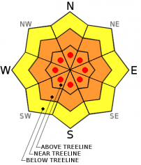
Below treeline today, MODERATE avalanche danger will exist on all aspects.
Near and above treeline, CONSIDERABLE avalanche danger will exist, all aspects.
Wind and storm slab avalanches will become increasingly unstable as they rapidly build in depth today and this wekeend.


Avalanche Problem 1: Storm Slab
-
Character ?

-
Aspect/Elevation ?

-
Likelihood ?CertainVery LikelyLikelyPossible
 Unlikely
 -
Size ?HistoricVery LargeLargeSmall

The storm that has ensued in the forecast area and has already brought 7 inches of new snow overnight with strong southerly winds. This winter storm will continue through the weekend bringing consistent, strong, south wind and heavy precipitation. Snow levels will fluctuate between 6,000 and 8,000 feet.
Storm snow will build rapidly at elevations above the freezing level, all aspects. Rapidly falling snow deposited over a short period of time is a red flag for avalanche danger. As this storm progresses and storm snow builds in depth, small to large avalanches are possible and could be sensitive to trigger.
Below treeline, expect MODERATE avalanche danger for all aspects on slopes steeper than 30 degrees. Near and above treeline on slopes steeper than 30 degrees, expect CONSIDERABLE avalanche danger, all aspects. The avalanche danger will increase as storm snow builds. Areas of HIGH avalanche danger are possible later today above treeline.
Remember what is above you. Avoid all avalanche terrain and low angle runout zones below treeline.
Avalanche Problem 2: Wind Slab
-
Character ?

-
Aspect/Elevation ?
-
Likelihood ?CertainVery LikelyLikelyPossible
Unlikely
-
Size ?HistoricVery LargeLargeSmall
Southerly winds are forecasted to blow all weekend with heavy precipitation at times. This will rapidly load leeward aspects on Mt Shasta. Near and above treeline, expect wind slabs to form and become very deep and unstable especially on NW-N-NE-E slopes as the storm progresses. Other aspects not suspected may also be wind loaded due to local terrain orographics.
For slopes steeper than 30 degrees, CONSIDERABLE avalanche danger will exist near and above treeline with pockets of HIGH danger possible later today. MODERATE avalanche danger will exist below treeline.
Avoid avalanche terrain and low angle runout zones on Mt Shasta. Large avalanches are possible as slabs grow deeper and more unstable on the upper mountain.
Recent Observations
Our month long, almost completely dry spell (only .48 inches of water fell in Mt Shasta over the month of January) has come to a screeching hault! A very impressive storm is happening now and is expected to deliver a healthy amount of water, snow and wind to the area. We received about 1.25 inches of water early in the week on February 2nd with high snow levels. The Old Ski Bowl weather station recorded very little new snow, however reports from the upper mountain observed up to 12 inches of new snow in areas after that short storm.
Overall, we have a smooth, firm bed surface that all this new snow is falling on. We will see fluctuating snow levels this weekend between 6,000 to 8,000 feet. This storm is arriving warmer, will cool a bit Saturday and then warm back up a bit on Sunday. Layering of the new storm snow could alternate between light and heavy snow. This is going to contribute to instability, especialy if we get heavier, dense snow on top of lighter density snow. Either way, we will see the avalanche danger crescendo as we move through the weekend. Observations over the week gave us a strong snowpack and no recent instabilities or weak layers observed.
=======================================================================================================
The Mt Shasta Avalanche Center has issued an AVALANCHE WATCH for the forecast area, in effect Friday 8am PDT through Saturday 8pm PDT.
The Mt Shasta area is forecasted to receive between 6 to 10 inches of water by Monday evening, which could mean 6-8 feet of snow near and above treeline on Mt Shasta. Snow levels will fluctuate between 6,000 and 8,000 feet. Extremely strong, south/southwest winds will accompany this storm which will predominantly load north and east slopes with deep snow. Concerns for small to increasingly large wind and storm slab avalanches exists for all aspects, near and above treeline on Mt Shasta this weekend.
Avalanches from the upper mountain may become large enough to impact lower elevation avalanche runout zones. Avoid travel in low angle runout zones below treeline.
Those traveling on Mt Shasta this weekend should have extensive avalanche knowledge and use careful route selection. Always travel with a partner and carry an avalanche beacon, shovel and probe... and know how to use them.
==============================================================================================================
The AVALANCHE WATCH will be re-evaluated at close of business on Saturday and potentially extended or upgraded to warning criteria.
Report your observations to the MSAC! A photo, a few words... send them in! (nimeyers@fs.fed.us or 530-926-9614)
Castle Lake area has a shallow snowpack. Be careful of shallow buried objects. Skiing has been reported as poor to non-existent.
Sand Flat Winter Trails: OPEN, trail conditions are firm and getting thin with some tree debris on snow surface.
Pilgrim Creek Snowmobile Park: OPEN, however due to lack of low elevation snow, one must drive up the road several miles before enough snow is encountered. One CANNOT DRIVE over Military Pass.
-------------------------------------------------------------------------------------------------------------------------------
Terrain: Remember most of the terrain that we like to play on is greater than 30 degrees. Avalanches are possible on anything steeper than 30 degrees. Avoid cornices, rock bands, terrain traps and runout zones of avalanche paths.
Weather: Most of our areas avalanche danger will occur 24-48 hours after a storm. We still can see persistent weak layers from time to time and we always will be sure to let you know about that! Heed the basic signs: Wind (significant snow transport and depositions), Temperature (rain/snow/rain/snow, which in turn weakens the snowpack), and Precipitation (Snow or rain add weight and stress to the current snowpack).
Snowpack: If snow accumulates, give the snowpack a chance to adjust to the new snow load before you play on or near steep slopes (greater than 30 degrees). Most direct action avalanches occur within 24-48 hours of recent snowfall. Watch for obvious signs of snowpack instability such as recent natural avalanche activity, collapsing of the snowpack (often associated with a “whumphing” sound), and shooting cracks. If you see these signs of instability, limit your recreation to lower angle slopes.
Human Factor: Don’t forget to carry and know how to use avalanche rescue gear. You should NOT be skiing or climbing potential avalanche slopes without having beacons, shovels, and probes. Only one person in a group should be exposed to potential avalanche danger at a time. Remember, climbing, skiing, and riding down the edge of slopes is safer than being in the center. Just because another person is on a slope doesn’t mean that it is safe. Be an individual! Make your own decisions. Heed the signs of instability: rapid warming, “whumphing” noises, shooting cracks, snowing an inch an hour or more, rain, roller balls, wind loading, recent avalanche activity.
The Five Red Flags of Avalanche Danger any time of year include: 1) Recent/current avalanche activity 2) Whumpfing sounds or shooting cracks 3) Recent/current heavy snowfall 4) Strong winds transporting snow 5) Rapid warming or rain on snow.
Weather and Current Conditions
Weather Summary
In Mt Shasta City this morning at 0500, we have a current temperature of 42 F degrees with heavy rain and gusty winds out of the ESE .
WEATHER STATION INFORMATION (0500hrs):
On Mt Shasta (South Side) in the last 24 hours...
Old Ski Bowl - 7,600 feet, the current temperature is 28 F. Snow on the ground totals 74 inches with 7 inches new snow in the last 24 hours. Temperatures in the last 24 hours have ranged from 27 F to 34 F. Over this past week, on Monday (2-2-15), the Old Ski Bowl weather station recorded 1.27 inches of water, but very little new snow fell at that elevation due to warm temperatures. Above the freezing level (>8,000 feet), up to 12 inches of new snow fell over the course of February 2nd.
Gray Butte - 8,000 feet, The current temperature is 29 F and temps have ranged from 27 F to 30 F in the last 24 hours. Winds have been blowing consistently out of the south/southwest over the past 24 hours, averaging 20 mph with frequent gusts to 49 mph.
Castle Lake and Mt Eddy (West side of Interstate-5)...
Castle Lake - 5,600 feet, the current temperature is 32 F. Temps have ranged from 32 F to 36 F in the last 24 hours. The Castle Lake area has up to 1.5 feet of snow on the ground and no new snow over the past week. The snow depth sensor has been in for repairs and will be installed soon. Thanks for you patience.
Mt Eddy - 6,500 feet, the current temperature is 30 F. Temps have ranged from 29 F to 35 F in the last 24 hours. Current snow depth is 19 inches with 3 inches new snow and no new snow over the week. Winds have averaged 4 mph and SW in direction, with gusts to 33 mph from the SW.
WEATHER SYNOPSIS: A wet and wild weekend has begun in the forecast area. Very windy conditions with heavy precipitation will bring a good cleansing to Mt Shasta City and deep snow on the mountain. Here is the breakdown for near and above treeline areas: Today, expect upwards of 3 inches of water with snow levels around 7,000 feet, which could mean several feet of new snow. Southerly winds will crank, 55-65 mph with gusts higher near and above treeline. Temperatures will begin to fall late today and lower snow levels to near 6,000 feet with .75 inches of water forecasted for Saturday, equalling up to a foot of snow. South winds will continue, 45-55 mph. Sunday, much more of the same... 1.50 inches of water forecasted, snow levels near 7,000 feet, and south wind 35-45 mph. Monday, we'll see lingering showers, south wind and similar snow levels. By Tuesday, the skies should begin to clear and reveal the glory of a beautiful storm.
THIS SEASON: Since October 1st (the wet season) , we have received 21.50 inches of water, normal is 23.48 inches, putting us at 91% of normal. For the month of February, we sit at 1.50 inches of water, normal is 1.21, putting us at 123% of normal. For the year of 2015, we've received 1.98 inches water, normal is 8.27, equalling 23% of normal.
Looking back into 2014, Mt Shasta finished off with 34.36 inches of water with normal being 43.21 inches, leaving us at 79% of normal for the year. For the month of December, Mt Shasta finished at 163% of normal, receiving 12.83 inches of water, normal is 7.85 inches.
Always check the weather before you attempt to climb Mt Shasta. Further, monitor the weather as you climb. Becoming caught on the mountain in any type of weather can compromise life and limb. Be prepared.
| 0600 temperature: | 28 |
| Max. temperature in the last 24 hours: | 34 |
| Average wind direction during the last 24 hours: | South/Southwest |
| Average wind speed during the last 24 hours: | 20 mi/hr |
| Maximum wind gust in the last 24 hours: | 49 mi/hr |
| New snowfall in the last 24 hours: | 7 inches |
| Total snow depth: | 74 inches |
Two Day Mountain Weather Forecast
Produced in partnership with the Medford NWS
| For 7000 ft to 9000 ft | |||
|---|---|---|---|
|
Friday (4 a.m. to 10 p.m.) |
Friday Night (10 p.m. to 4 a.m.) |
Saturday (4 a.m. to 10 p.m.) |
|
| Weather | Rain and snow, becoming snow after 10am. Rain/snow heavy at times | Rain and snow, heavy at times | Rain and snow |
| Temperature (°F) | 38 | 34 | 39 |
| Wind (mi/hr) | South 25-35 mph with higher gusts | South 20-30 mph with gusts higher | South 15-25 mph with gusts higher |
| Precipitation SWE / Snowfall (in) | / 19-25 | / 10-16 | / 1-3 |
| For 9000 ft to 11000 ft | |||
| Friday | Friday Night | Saturday | |
| Weather | Snow | Snow | Snow |
| Temperature (°F) | 29 | 23 | 27 |
| Wind (mi/hr) | South 55-65 mph with gusts higher | Southwest 17-23 | Southwest 45-55 mph with gusts higher |
| Precipitation SWE / Snowfall (in) | / 17-23 | / 13-19 | / 5-9 |

