

You are here
Avalanche Advisory for 2015-02-08 07:02:13
- EXPIRED ON February 9, 2015 @ 7:02 amPublished on February 8, 2015 @ 7:02 am
- Issued by Nick Meyers - Shasta-Trinity National Forest
Bottom Line
The avalanche danger will increase as one gains elevation on Mt Shasta.
Below and near treeline, LOW to MODERATE danger will exist on slopes steeper than 35 degrees, all aspects.
Above treeline, uncertainty remains and CONSIDERABLE avalanche danger may be found in corniced, wind loaded areas above 8,600 feet, slopes steeper than 35 degrees.
Careful snowpack evaluation, cautious route finding and conservative decision making are essential for above treeline travel.


Avalanche Problem 1: Wind Slab
-
Character ?

-
Aspect/Elevation ?
-
Likelihood ?CertainVery LikelyLikelyPossible
 Unlikely
 -
Size ?HistoricVery LargeLargeSmall

Wind slabs that did not naturally occur already may still be sensitive to trigger today for areas above treeline. Rising snow levels and our warming period from yesterday have deposited high density snow on top of relatively lower density snow creating an opportunity for slab over non-persistent weak layer formation. Slabs are possible still, 2-6 feet deep in heavily wind loaded areas.
With several more inches of water and increasing southerly winds expected with this last storm today/tomorrow, we could see another 1-2 feet of snow fall on the mountain and further wind loading.
Do not forget about the terrain above you. Lower angle runout zones could be impacted by large and unusual slides caused by such conditions as we are seeing.
Avalanche Problem 2: Storm Slab
-
Character ?

-
Aspect/Elevation ?

-
Likelihood ?CertainVery LikelyLikelyPossible
Unlikely
-
Size ?HistoricVery LargeLargeSmall
Storm slabs are possible above treeline where new snow was deposited on top of old snow surfaces. An additional 1-2 feet of storm snow expected today and tomorrow will increase the chance of storm slabs avlanches. The avalanche danger will rise over the next 24-36 hours.
Avalanche Problem 3: Cornice
-
Character ?

-
Aspect/Elevation ?

-
Likelihood ?CertainVery LikelyLikelyPossible
Unlikely
-
Size ?HistoricVery LargeLargeSmall
Avoid recently built ridge-top cornices, which might break further back than you expect and could trigger avalanches on steep slopes below. Natural cornice fall avalanches are possible in some areas as drifting continues with strong winds today.
Recent Observations
A quick recap of the storm series that began Thursday (2.5.15) evening... a very impressive wet and windy storm fell on the Mt Shasta area... the first wave provided 33.5 inches of snow (5.38 inches water) over 36 hours, recorded at 7,600 feet on the south side of Mt Shasta (Old Ski Bowl weather station). Winds averaged 20-30 mph, southeast to southwest with gusts into the 40's and 50's, recorded at the Gray Butte weather station, 8,000 feet, also on the south side of Shasta. Snow levels fell as low as 5,000 feet during the beginning of the storm, but most of the snow was above 6,000 and snow levels have been as high as 8,500 feet.
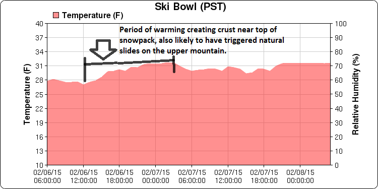
Fluctuating temps did some funky things to the snowpack yesterday... High avalanche danger, powdery dreams and the snowpack were all squished by a rapid warming in temperature that consolidated the snowpack several inches, and lowered the avalanche danger by the end of the day on all aspects below and near treeline. Temps cooled back down soon after this warm up and created a 2-3cm zipper crust layer that is now overlaying our storm snow. Poor visibility allowed us to make it to only about 8,500 feet in the Old Ski Bowl and this crust layer was still present at that location. It's uncertain at what elevation the crust may disappear.
Avalanche activity above treeline, which was almost certain, probably occured during this warm up albeit out of view for us. The spike in danger has subsided for below and near treeline areas and no natural or human triggered avalanches were observed. Stability tests and observations yesterday revealed good stability for said areas and we saw widespread consolidation and stabilization within the snowpack due to the warmer temps. That said, we were not able to get a view of the upper mountain and uncertainty lingers regarding the avalanche danger above treeline, above the freezing level. Further uncertainty remains as to which layer(s) within the snowpack will be weakest at mid to upper mountain levels. While we don't sit at high danger any longer, I do believe things could still be touchy above treeline, higher than 8,600 feet.
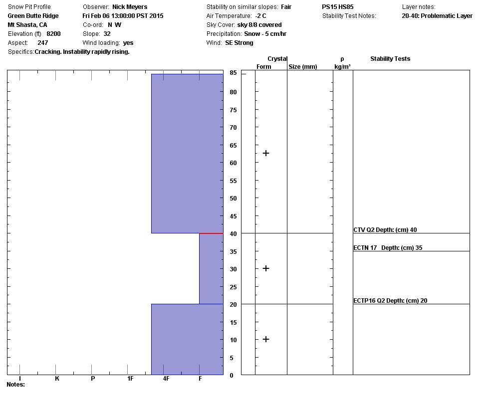
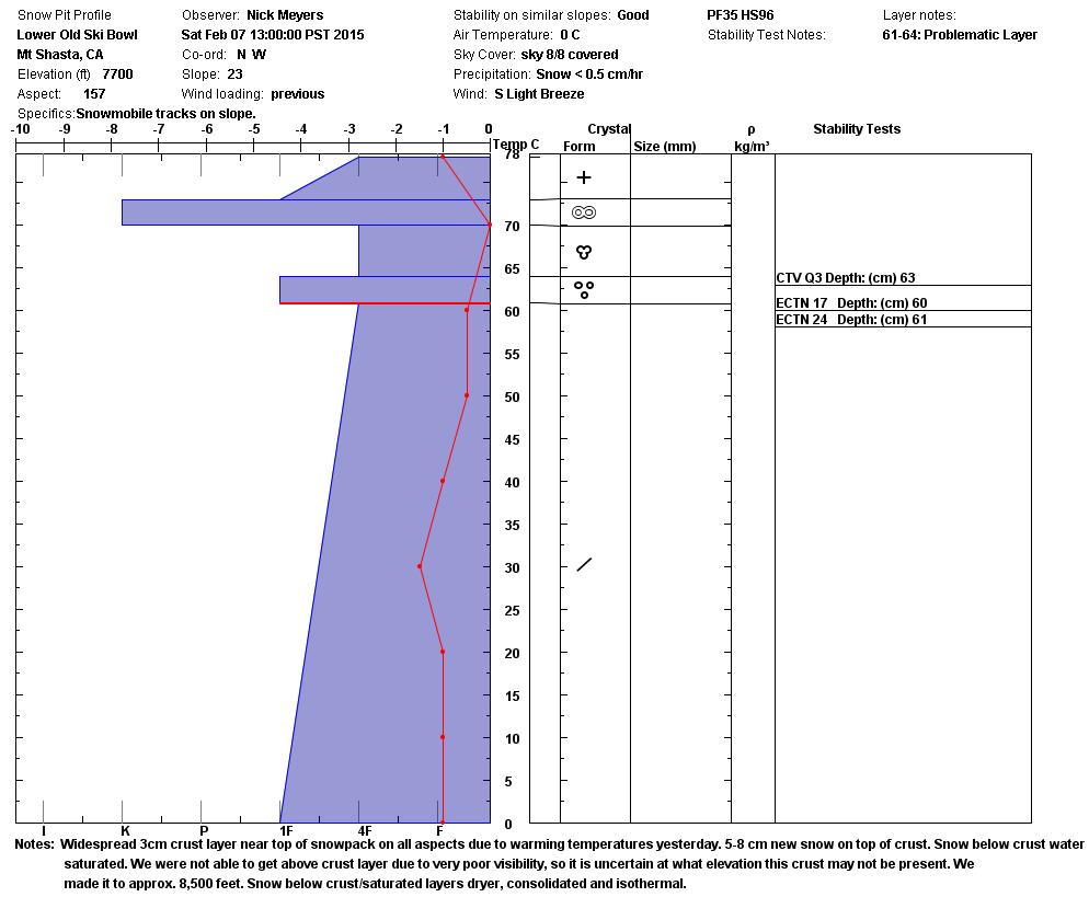
Pit profile below on the top shows the snowpack soon after the first storm wave. The second profile on bottom shows the snowpack after our warm up and formation of crust layer(s) and saturated snow within top layers. Poor propagation and poor shear quality was found within weakest layer, just below saturdated, wet snow.
The bottom line synopsis: Below and near treeline areas.... the avalanche danger has dropped considerably from warm up/cool down. Areas above treeline remain uncertain and considerable avalanche danger could be found. Weak layers may exist within Friday/Saturdays wind and storm slabs, or form within new/expected snow. Today, visibility will remain poor and more snow and southwest wind are forecasted with cooling temps. While this is welcomed by all powder hounds alike and will hopefully put a nice light density, snowy finish to our weekend storm series, we will continue to see potentially dangerous avalanche conditions above 8,600 feet on slopes steeper than 30 degrees. Cornices and wind loaded starting zones should be avoided for the next several days.
Report your observations to the MSAC! A photo, a few words... send them in! (nimeyers@fs.fed.us or 530-926-9614)
Castle Lake area has a shallow snowpack. Be careful of shallow buried objects. Skiing has been reported as poor to non-existent.
Sand Flat Winter Trails: OPEN, trail conditions are firm and getting thin with some tree debris on snow surface.
Pilgrim Creek Snowmobile Park: OPEN, however due to lack of low elevation snow, one must drive up the road several miles before enough snow is encountered. One CANNOT DRIVE over Military Pass.
-------------------------------------------------------------------------------------------------------------------------------
Terrain: Remember most of the terrain that we like to play on is greater than 30 degrees. Avalanches are possible on anything steeper than 30 degrees. Avoid cornices, rock bands, terrain traps and runout zones of avalanche paths.
Weather: Most of our areas avalanche danger will occur 24-48 hours after a storm. We still can see persistent weak layers from time to time and we always will be sure to let you know about that! Heed the basic signs: Wind (significant snow transport and depositions), Temperature (rain/snow/rain/snow, which in turn weakens the snowpack), and Precipitation (Snow or rain add weight and stress to the current snowpack).
Snowpack: If snow accumulates, give the snowpack a chance to adjust to the new snow load before you play on or near steep slopes (greater than 30 degrees). Most direct action avalanches occur within 24-48 hours of recent snowfall. Watch for obvious signs of snowpack instability such as recent natural avalanche activity, collapsing of the snowpack (often associated with a “whumphing” sound), and shooting cracks. If you see these signs of instability, limit your recreation to lower angle slopes.
Human Factor: Don’t forget to carry and know how to use avalanche rescue gear. You should NOT be skiing or climbing potential avalanche slopes without having beacons, shovels, and probes. Only one person in a group should be exposed to potential avalanche danger at a time. Remember, climbing, skiing, and riding down the edge of slopes is safer than being in the center. Just because another person is on a slope doesn’t mean that it is safe. Be an individual! Make your own decisions. Heed the signs of instability: rapid warming, “whumphing” noises, shooting cracks, snowing an inch an hour or more, rain, roller balls, wind loading, recent avalanche activity.
The Five Red Flags of Avalanche Danger any time of year include: 1) Recent/current avalanche activity 2) Whumpfing sounds or shooting cracks 3) Recent/current heavy snowfall 4) Strong winds transporting snow 5) Rapid warming or rain on snow.
Weather and Current Conditions
Weather Summary
In Mt Shasta City this morning at 0500, we have a current temperature of 48 F degrees, 2 degrees warmer than yesterday with obscured skies and light rain.
WEATHER STATION INFORMATION (0500hrs):
On Mt Shasta (South Side) in the last 24 hours...
Old Ski Bowl - 7,600 feet, the current temperature is 31 F, the same temperature as yesterday morning. Snow on the ground totals 96 inches with 2-4 inches new snow in the last 24 hours. We've seen 2-3 inches of settlement and a storm total since 2.6.15 of 37 inches. Temperatures in the last 24 hours have ranged from 29 F to 31 F.
Gray Butte - 8,000 feet, The current temperature is 31 F and temps have ranged from 28 F to 31 F in the last 24 hours. Winds have been primarily out of the west over the past 24 hours, averaging 10-15 mph with gusts to 42 mph.
Castle Lake and Mt Eddy (West side of Interstate-5)...
Castle Lake - 5,600 feet, the current temperature is 37 F. Temps have ranged from 34 F to 38 F in the last 24 hours. The Castle Lake area has some snow on the ground though has been receiving mostly rain. The snow depth sensor has been in for repairs and will be installed soon. Thanks for you patience.
Mt Eddy - 6,500 feet, the current temperature is 33 F. Temps have ranged from 32 F to 35 F in the last 24 hours. Current snow depth is 35 inches, 3-5 inches settlement, with approximately 2-4 inches new snow over the last 24 hours and a storm total of 25 inches (since 2.6.15). Winds have averaged 2 mph and SW in direction, with gusts to 12 mph from the SW.
WEATHER SYNOPSIS: It’s been quite the stormy weekend for the region, and it's not quite over yet. The third and final storm system of the group will come on shore today bringing an increase in winds and more precipitation. The storm will be wet, up to 2.5 inches of water, however it will not be as intense as Friday’s storm. Southwest/west winds, however, will increase later today, so much so as to warrant a high wind warning. Expect 50+ mph for the mid and upper mountain levels with gusts higher. Snow levels are going to remain high this morning, 7,000 to 8,000 feet. Cold air will move over the area later today and drop temperature on the mountain several degrees, lowering snow levels down to near 5,000 feet late tonight and tomorrow, providing potentially a nice finish to this storm with some lighter density snow! If that wasn't enough for you, there is also a slight chance of some lightning with this system. Overall, this low will pass through today and into Monday, leaving mostly sunny skies by Tuesday. A high pressure ridge returns mid-week blocking any moisture until at least next weekend.
THIS SEASON: Since October 1st (the wet season) , we have received 26.74 inches of water, normal is 23.97 inches, putting us at 111% of normal. For the month of February, we sit at 6.74 inches of water, normal is 1.70, putting us at 396% of normal. For the year of 2015, we've received 7.22 inches water, normal is 8.76, equalling 82% of normal.
Looking back into 2014, Mt Shasta finished off with 34.36 inches of water with normal being 43.21 inches, leaving us at 79% of normal for the year. For the month of December, Mt Shasta finished at 163% of normal, receiving 12.83 inches of water, normal is 7.85 inches.
Always check the weather before you attempt to climb Mt Shasta. Further, monitor the weather as you climb. Becoming caught on the mountain in any type of weather can compromise life and limb. Be prepared.
| 0600 temperature: | 31 |
| Max. temperature in the last 24 hours: | 31 |
| Average wind direction during the last 24 hours: | West |
| Average wind speed during the last 24 hours: | 10-15 mi/hr |
| Maximum wind gust in the last 24 hours: | 28 mi/hr |
| New snowfall in the last 24 hours: | 2-4 inches |
| Total snow depth: | 96 inches |
Two Day Mountain Weather Forecast
Produced in partnership with the Medford NWS
| For 7000 ft to 9000 ft | |||
|---|---|---|---|
|
Sunday (4 a.m. to 10 p.m.) |
Sunday Night (10 p.m. to 4 a.m.) |
Monday (4 a.m. to 10 p.m.) |
|
| Weather | Mostly cloudy with rain, winds increasing mid-day | Rain and snow with a slight chance of thunderstorms after midnight | Mostly cloudy with rain and snow |
| Temperature (°F) | 40 | 35 | 33 |
| Wind (mi/hr) | South 15-25 mph with higher gusts | South 25-35 mph with gusts higher | South 15-25 mph with gusts higher |
| Precipitation SWE / Snowfall (in) | / 0 | / 3-5 | / 2-3 |
| For 9000 ft to 11000 ft | |||
| Sunday | Sunday Night | Monday | |
| Weather | Snow | Mostly cloudy with snow, windy | Mostly cloudy, snow |
| Temperature (°F) | 30 | 20 | 24 |
| Wind (mi/hr) | South 40-50 mph with gusts higher | South 6-10 | Southwest 50-55 mph, decreasing to 40-45 mph mid-day |
| Precipitation SWE / Snowfall (in) | / 6-10 | / 6-10 | / 2-4 |

