

You are here
Avalanche Advisory for 2015-02-15 06:39:43
- EXPIRED ON February 16, 2015 @ 6:39 amPublished on February 15, 2015 @ 6:39 am
- Issued by Nick Meyers - Shasta-Trinity National Forest
Bottom Line
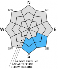
The avalanche danger is LOW for all elevations and aspects.
Isolated, wet/loose avalanches may be possible in the form of roller balls, pinwheels and small point releases today in below, near and above treeline areas up to 9,500 feet.
Warm, southeast and south facing slopes, 37 degrees and steeper, have the best chance to host wet/loose snow instabilities. Larger wet loose avalanches are unlikely.
Normal caution advised.


Avalanche Problem 1: Loose Wet
-
Character ?

-
Aspect/Elevation ?
-
Likelihood ?CertainVery LikelyLikelyPossible
 Unlikely
 -
Size ?HistoricVery LargeLargeSmall

Our snowpack continues to transition to melt-freeze. Temperatures have cooled by a couple of degrees today. We will see the temperatures warm/cool at different elevations over the next few days, but overall, we'll see a few degree decrease in temp through the begining of the week for most areas of recreation.
LOW avalanche danger exists for human triggered, loose wet avalanche activity, most likely in the form of roller balls and pin wheels. Warm, southeast and south facing slopes will be most prone, low to mid elevations up to 9,500 feet, slopes 37 degrees and steeper. Actual loose wet avalanches, if observed, will be isolated and small in size.
Avalanche Problem 2: Normal Caution
-
Character ?

-
Aspect/Elevation ?
-
Likelihood ?CertainVery LikelyLikelyPossible
Unlikely
-
Size ?HistoricVery LargeLargeSmall
CARRY A BEACON, SHOVEL AND PROBE AND KNOW HOW TO USE THEM!
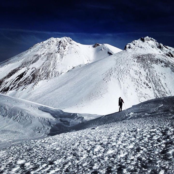
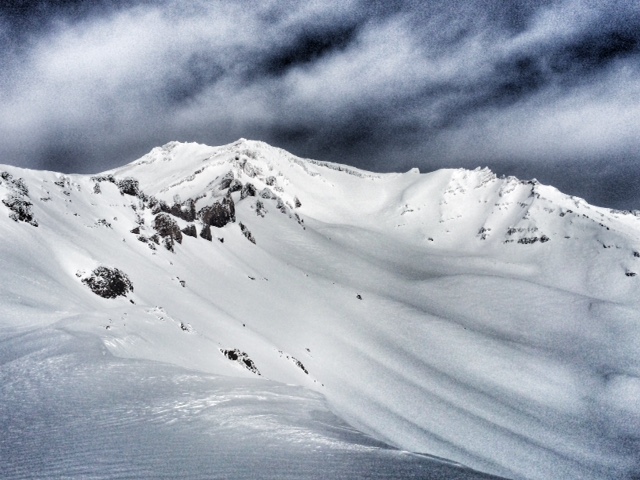
Photo: S Larsen
Recent Observations
There is not much new to report for the weather, or changes in the snow pack. Another beautiful, sunny and mild day is on tap today for Mount Shasta and the surrounding area. The melt/freeze conditions have continued to work their magic on our snow pack creating prime corn snow for your enjoyment. We're sure it goes with out saying that aspect, elevation, and time of day are going to dictate snow quality and condition. Low to mid elevation south-southeast slopes will offer the best chance for daytime softening and prime corn conditions. Yesterday, good corn snow was present up to at around 11,000 feet and good ski conditions were reported in Avalanche Gulch from Helen Lake down. Good corn snow conditions were also observed in Old Ski Bowl as snowmobilers frolicked about.
The warm daytime temperatures and mild night time lows continue to consolidate and stabilize the 3-4 feet of new snow received last weekend. No snow instabilities were observed or reported yesterday as plenty of folks ventured up onto the flanks of Mt. Shasta to enjoy winter's white gift. Currently, confidence remains high for increasing snowpack stability. Snow crystals continue to bond and gain strength due to the sunny days, and an isothermal snowpack (constant temperature throughout snow layers) was observed. Winds will not be much of a factor as they will be light at 5-15 mph coming from variable directions, Easterly to more Northerly over the next couple of days.
Images:
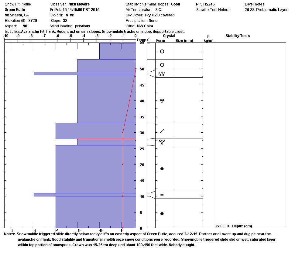
Pit profile from Friday (2/13/15).
A look into Avalanche Gulch from Casaval Ridge from 2.11.15 - Photo: H Meyers
Report your observations to the MSAC! A photo, a few words... send them in! (nimeyers@fs.fed.us or 530-926-9614)
Castle Lake area has a shallow snowpack. Be careful of shallow buried objects. Skiing has been reported as poor to non-existent. The road to Castle Lake is currently CLOSED due to flooding and culvert damage that washed out the road.
Sand Flat Winter Trails: OPEN, trail conditions are firm and getting thin with some tree debris on snow surface.
Pilgrim Creek Snowmobile Park: OPEN, however due to lack of low elevation snow, one must drive up the road several miles before enough snow is encountered. One CANNOT DRIVE over Military Pass.
-------------------------------------------------------------------------------------------------------------------------------
Terrain: Remember most of the terrain that we like to play on is greater than 30 degrees. Avalanches are possible on anything steeper than 30 degrees. Avoid cornices, rock bands, terrain traps and runout zones of avalanche paths.
Weather: Most of our areas avalanche danger will occur 24-48 hours after a storm. We still can see persistent weak layers from time to time and we always will be sure to let you know about that! Heed the basic signs: Wind (significant snow transport and depositions), Temperature (rain/snow/rain/snow, which in turn weakens the snowpack), and Precipitation (Snow or rain add weight and stress to the current snowpack).
Snowpack: If snow accumulates, give the snowpack a chance to adjust to the new snow load before you play on or near steep slopes (greater than 30 degrees). Most direct action avalanches occur within 24-48 hours of recent snowfall. Watch for obvious signs of snowpack instability such as recent natural avalanche activity, collapsing of the snowpack (often associated with a “whumphing” sound), and shooting cracks. If you see these signs of instability, limit your recreation to lower angle slopes.
Human Factor: Don’t forget to carry and know how to use avalanche rescue gear. You should NOT be skiing or climbing potential avalanche slopes without having beacons, shovels, and probes. Only one person in a group should be exposed to potential avalanche danger at a time. Remember, climbing, skiing, and riding down the edge of slopes is safer than being in the center. Just because another person is on a slope doesn’t mean that it is safe. Be an individual! Make your own decisions. Heed the signs of instability: rapid warming, “whumphing” noises, shooting cracks, snowing an inch an hour or more, rain, roller balls, wind loading, recent avalanche activity.
The Five Red Flags of Avalanche Danger any time of year include: 1) Recent/current avalanche activity 2) Whumpfing sounds or shooting cracks 3) Recent/current heavy snowfall 4) Strong winds transporting snow 5) Rapid warming or rain on snow.
Weather and Current Conditions
Weather Summary
In Mt Shasta City this morning at 0500, we have mostly clear skies and a current temperature of 33 F degrees, 8 degrees cooler than yesterday, with inversions in the area.
WEATHER STATION INFORMATION (0500hrs):
On Mt Shasta (South Side) in the last 24 hours...
Old Ski Bowl - 7,600 feet, the current temperature is 40 F. Snow on the ground totals 93 inches with .75 inches settlement. Temperatures in the last 24 hours have ranged from 39 F to 50 F.
Gray Butte - 8,000 feet, The current temperature is 43 F and temps have ranged from 41 F to 51 F in the last 24 hours. Winds have been primarily out of the East, averaging 5 mph with gusts to 28 mph in the last 24 hours.
Castle Lake and Mt Eddy (West side of Interstate-5)...
Castle Lake - 5,600 feet, the current temperature is 39 F. Temps have ranged from 39 F to 54 F in the last 24 hours. The Castle Lake area has some snow on the ground though has been receiving mostly rain. The snow depth sensor has been in for repairs and will be installed soon.
Mt Eddy - 6,500 feet, the current temperature is 42 F. Temps have ranged from 36 F to 52 F in the last 24 hours. Current snow depth is 32 inches with .75 inch settlement. Winds have averaged 2 mph and variable in direction, with gusts to 12 mph, WSW.
WEATHER SYNOPSIS: Get ready for another beautiful sunny day on Mount Shasta! Not much will change today in terms of weather. Slight temperature inversions remain in place, and winds will stay primarily easterly in direction at 5-15 mph. Predictions for wind speeds have been reduced slightly from what was forecast yesterday due to a lesser East to West pressure gradient. Freezing levels will hover slightly above 11,000 feet today and Monday, lowering on Tuesday. These conditions will remain mostly unchanged for Monday with only some slight cooling by a couple of degrees through the remainder of the week. Mostly sunny skies, and mild temperatures will be the name of the game.
THIS SEASON: Since October 1st (the wet season) , we have received 30.10 inches of water, normal is 25.67 inches, putting us at 117% of normal. For the month of February, we sit at 10.10 inches of water, normal is 3.40, putting us at 297% of normal. For the year of 2015, we've received 10.58 inches water, normal is 10.46, equalling 101% of normal.
Looking back into 2014, Mt Shasta finished off with 34.36 inches of water with normal being 43.21 inches, leaving us at 79% of normal for the year. For the month of December, Mt Shasta finished at 163% of normal, receiving 12.83 inches of water, normal is 7.85 inches.
Always check the weather before you attempt to climb Mt Shasta. Further, monitor the weather as you climb. Becoming caught on the mountain in any type of weather can compromise life and limb. Be prepared.
| 0600 temperature: | 40 |
| Max. temperature in the last 24 hours: | 50 |
| Average wind direction during the last 24 hours: | Easterly |
| Average wind speed during the last 24 hours: | 5 mi/hr |
| Maximum wind gust in the last 24 hours: | 28 mi/hr |
| New snowfall in the last 24 hours: | 0 inches |
| Total snow depth: | 93 inches |
Two Day Mountain Weather Forecast
Produced in partnership with the Medford NWS
| For 7000 ft to 9000 ft | |||
|---|---|---|---|
|
Sunday (4 a.m. to 10 p.m.) |
Sunday Night (10 p.m. to 4 a.m.) |
Monday (4 a.m. to 10 p.m.) |
|
| Weather | Sunny | Mostly clear | Sunny |
| Temperature (°F) | 42 | 37 | 52 |
| Wind (mi/hr) | East/Southeast 5-10 mph | Northeast 5-10 mph | Northeast 5-10 mph |
| Precipitation SWE / Snowfall (in) | / 0 | / 0 | / 0 |
| For 9000 ft to 11000 ft | |||
| Sunday | Sunday Night | Monday | |
| Weather | Sunny | Mostly clear | Sunny |
| Temperature (°F) | 37 | 38 | 48 |
| Wind (mi/hr) | North/northeast 10-20 mph | North/northwest 0 | Northerly 10-20 mph |
| Precipitation SWE / Snowfall (in) | / 0 | / 0 | / 0 |

