

You are here
Avalanche Advisory for 2015-02-27 06:53:52
- EXPIRED ON February 28, 2015 @ 6:53 amPublished on February 27, 2015 @ 6:53 am
- Issued by Nick Meyers - Shasta-Trinity National Forest
Bottom Line
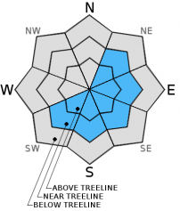
Above treeline, there is MODERATE danger for triggering shallow wind slab avalanches, small to medium in size. Due to steady northwest winds (20-30 mph gusting 50-60 mph over the last 24 hours) with 2.5 inches of new snow overnight, wind loading is expected mostly on upper elevation, steep, wind exposed terrain that is NE-E-SE-S-SW facing.
The avalanche danger is LOW for below treeline areas and all aspects.
Near treeline, the danger is LOW with pockets of MODERATE.


Avalanche Problem 1: Wind Slab
-
Character ?

-
Aspect/Elevation ?
-
Likelihood ?CertainVery LikelyLikelyPossible
 Unlikely
 -
Size ?HistoricVery LargeLargeSmall

A couple inches of new snow combined with steady northwest wind has likely formed isolated wind slabs primarily above treeline and in exposed areas. Spacial variability is going to be the key term here. While some areas are going to be scoured down to the old, firm snowpack, adjacent slopes and isolated pockets could host small to medium size wind slabs.
Slopes steeper than 35 degrees and NE-E-SE-S-SW facing and near ridge crests and the lee side of terrain features should be most suspect. Danger will exist for newly deposited wind slabs sliding on the old snow surface.
Be on the lookout for instability such as cracking in the snow surface and also smooth, rounded deposits of wind drifted snow.
Recent Observations
Our old, firm snowpack waited patiently for a refresh, and it got it! While we are not seeing impressive new snow totals, I will refer to the well used saying... "It's better than nothing!"
Up until the new snow we received over the last 24 hours, we sat in an idle period of clear weather with great corn skiing at times. Our snowpack below this new snow is, bomber. That means it's very strong, isothermal, equitemperature, no persistent weak layers of concern. Observations over the week found overall smooth and firm snow surface conditions with south and southeast aspects, low to mid elevations softening at times. Upper elevations stayed mostly firm. Ice fall (rime ice) off exposed rocks is an ongoing issue for climbers and skiers venturing onto the upper mountain. Wear a helmet and stay out of the fall line of exposed rocks/ice above. Smooth, firm snow surface conditions also mean that a slip and fall can result in a long slide for life. Self arrest skills with said conditions are an important asset to have should one choose to climb.
Concern for today and the weekend will lie within the wind slab avalanche problem. Cooler temperatures during this storm has deposited a couple inches of new, light density snow on the mountain. The Old Ski Bowl station recorded about 2.5 inches new snow. Gray Butte station has shown northwest winds blowing steadily during the storm, 20-30 mph with gusts 50+ mph. This new snow is ripe for transport and we will see some wind loading in isolated areas. Spacial variability will be the name of the game: some areas will likely see scouring down to the old snow surface while adjacent slopes will host shallow, small to medium size wind slabs. Smooth, round slabs will have formed on top of the old snow surface and could be triggered by a skier or rider. Leeward areas above treeline, near ridgelines and extreme terrain should be most suspect.
Castle Lake and Mt Eddy zones are still hosting shallow snowpacks. All areas below about 6,000 feet in the forecast area are hosting patchy snow with dirt showing around trees and in sunny spots.
Report your observations to the MSAC! A photo, a few words... send them in! (nimeyers@fs.fed.us or 530-926-9614)
Castle Lake area has a shallow snowpack. Skiing is out of the question at this point due to lack of snow.
Sand Flat Winter Trails: OPEN, trail conditions are firm and getting thin with some tree debris on snow surface.
Pilgrim Creek Snowmobile Park: OPEN, however due to lack of low elevation snow, one must drive up the road several miles before enough snow is encountered. One CANNOT DRIVE over Military Pass. Snowmobiling is not recommended due to low snow depths.
-------------------------------------------------------------------------------------------------------------------------------
Terrain: Remember most of the terrain that we like to play on is greater than 30 degrees. Avalanches are possible on anything steeper than 30 degrees. Avoid cornices, rock bands, terrain traps and runout zones of avalanche paths.
Weather: Most of our areas avalanche danger will occur 24-48 hours after a storm. We still can see persistent weak layers from time to time and we always will be sure to let you know about that! Heed the basic signs: Wind (significant snow transport and depositions), Temperature (rain/snow/rain/snow, which in turn weakens the snowpack), and Precipitation (Snow or rain add weight and stress to the current snowpack).
Snowpack: If snow accumulates, give the snowpack a chance to adjust to the new snow load before you play on or near steep slopes (greater than 30 degrees). Most direct action avalanches occur within 24-48 hours of recent snowfall. Watch for obvious signs of snowpack instability such as recent natural avalanche activity, collapsing of the snowpack (often associated with a “whumphing” sound), and shooting cracks. If you see these signs of instability, limit your recreation to lower angle slopes.
Human Factor: Don’t forget to carry and know how to use avalanche rescue gear. You should NOT be skiing or climbing potential avalanche slopes without having beacons, shovels, and probes. Only one person in a group should be exposed to potential avalanche danger at a time. Remember, climbing, skiing, and riding down the edge of slopes is safer than being in the center. Just because another person is on a slope doesn’t mean that it is safe. Be an individual! Make your own decisions. Heed the signs of instability: rapid warming, “whumphing” noises, shooting cracks, snowing an inch an hour or more, rain, roller balls, wind loading, recent avalanche activity.
The Five Red Flags of Avalanche Danger any time of year include: 1) Recent/current avalanche activity 2) Whumpfing sounds or shooting cracks 3) Recent/current heavy snowfall 4) Strong winds transporting snow 5) Rapid warming or rain on snow.
Weather and Current Conditions
Weather Summary
In Mt Shasta City this morning at 0500, we have clear skies and a current temperature of 37 F degrees.
WEATHER STATION INFORMATION (0500hrs):
On Mt Shasta (South Side) in the last 24 hours...
Old Ski Bowl - 7,600 feet, the current temperature is 29 F. We have received .08 inches of water in the last 24 hours and 2.5 inches of new snow at the Old Ski Bowl station. Snow on the ground totals 90 inches with no settlement. Temperatures in the last 24 hours have ranged from 28 F to 41 F.
Gray Butte - 8,000 feet, The current temperature is 27 F and temps have ranged from 26 F to 37 F in the last 24 hours. Winds have averaged 20-30 mph and northwest in direction with gusts to 56 mph, NW.
Castle Lake and Mt Eddy (West side of Interstate-5)...
Castle Lake - 5,600 feet, the current temperature is 31 F. Temps have ranged from 30 F to 45 F in the last 24 hours. New snow in the last 24 hours totals .5 inches. The Castle Lake area has overall a patchy 10 inches of snow on the ground.
Mt Eddy - 6,500 feet, the current temperature is 28 F. Temps have ranged from 28 F to 37 F in the last 24 hours. Current snow depth is 30 inches with no settlement and 1-2 inches new snow in the last 24 hours.. Winds have averaged 2-4 mph, with gusts to 14 mph, southeast.
WEATHER SYNOPSIS: The current low slides down from the northwest and already has brought a few inches of new snow to the mountain overnight and we could see a bit more... but nothing to promote getting the ski snorkels out. Today, we'll see an additional .10-.15 inches precipitation (water) with snow levels hovering around 4,000 to 5,000 feet. This could mean a couple more inches on the mountain, however looking at satellite models and the sky this morning, it's looking pretty clear, so we'll see. We are not that impressed with the predication of more precip as of now. Northwest winds have been blowing steadily 20-30 mph over the past 24 hours with gusts 50-60 mph...we should see these winds diminish through the day and become light to moderate for the weekend. By Sunday, sunshine should be back in action and shining strong, however temperatures will be cooler as cold air pushes down from the northwest.
THIS SEASON: Since October 1st (the wet season) , we have received 30.10 inches of water, normal is 28.96 inches, putting us at 103% of normal. For the month of February, we sit at 10.10 inches of water, normal is 6.69, putting us at 150% of normal. For the year of 2015, we've received 10.58 inches water, normal is 13.75, equalling 76% of normal.
Looking back into 2014, Mt Shasta finished off with 34.36 inches of water with normal being 43.21 inches, leaving us at 79% of normal for the year. For the month of December, Mt Shasta finished at 163% of normal, receiving 12.83 inches of water, normal is 7.85 inches.
Always check the weather before you attempt to climb Mt Shasta. Further, monitor the weather as you climb. Becoming caught on the mountain in any type of weather can compromise life and limb. Be prepared.
| 0600 temperature: | 29 |
| Max. temperature in the last 24 hours: | 41 |
| Average wind direction during the last 24 hours: | Northwest |
| Average wind speed during the last 24 hours: | 20-30 mi/hr |
| Maximum wind gust in the last 24 hours: | 56 mi/hr |
| New snowfall in the last 24 hours: | 2.5 inches |
| Total snow depth: | 90 inches |
Two Day Mountain Weather Forecast
Produced in partnership with the Medford NWS
| For 7000 ft to 9000 ft | |||
|---|---|---|---|
|
Friday (4 a.m. to 10 p.m.) |
Friday Night (10 p.m. to 4 a.m.) |
Saturday (4 a.m. to 10 p.m.) |
|
| Weather | Snow showers with chance of thunder | Snow showers, chance of thunder | Chance of snow showers in the morning, otherwise mostly cloudy |
| Temperature (°F) | 33 | 22 | 32 |
| Wind (mi/hr) | Northeast 10-15 mph, gusty | Northwest 5-10 mph | Northwest 5-10 mph |
| Precipitation SWE / Snowfall (in) | / 1-3 | / 1-2 | / 0-.5 |
| For 9000 ft to 11000 ft | |||
| Friday | Friday Night | Saturday | |
| Weather | Snow showers with chance of thunder | Snow showers, thunder possible | Chance of snow showers, otherwise mostly cloudy |
| Temperature (°F) | 31 | 11 | 27 |
| Wind (mi/hr) | Northwest 20-30 mph with gusts 50-60 mph, decreasing in the afternoon. Wind chill as low as -4 | North 2-4 | Northeast 10-15 mph with gusts higher |
| Precipitation SWE / Snowfall (in) | / 2-4 | / 2-4 | / 0-.5 |

