

You are here
Avalanche Advisory for 2015-03-01 07:04:27
- EXPIRED ON March 2, 2015 @ 7:04 amPublished on March 1, 2015 @ 7:04 am
- Issued by Nick Meyers - Shasta-Trinity National Forest
Bottom Line
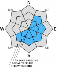
Above treeline, there is MODERATE danger for human triggered wind slab avalanches, small to medium in size, in wind exposed terrain that is NE-E-SE-S-SW facing. Be able to identify newly formed wind slabs to make safe travel decisions in avalanche terrain.
Near treeline, the danger is LOW with pockets of MODERATE for triggering small wind slabs, all aspects.
The avalanche danger is LOW for below treeline areas and all aspects.


Avalanche Problem 1: Wind Slab
-
Character ?

-
Aspect/Elevation ?
-
Likelihood ?CertainVery LikelyLikelyPossible
 Unlikely
 -
Size ?HistoricVery LargeLargeSmall

Human triggered wind slab avalanches are possible today. Slopes steeper than 35 degrees and NE-E-SE-S-SW facing and near ridge crests and the lee side of terrain features will be the best places to find these wind slabs and wind pillows.
Spatial variability is going to be the main concept today. A couple inches of new snow combined with moderate to high wind speeds has formed isolated wind slabs above tree line and in wind exposed slopes. While some areas are going to be scoured down to the old, firm snowpack, steeper slopes and isolated pockets in extreme terrain will host small to medium size wind slabs / wind pillows.
Look for smooth, rounded deposits of wind drifted snow with signs of instability such as whoomfing and cracking in the snow surface.
Recent Observations
A chilly and windy day above treeline on Saturday, the last day of February. Yesterday, the snow surface conditions on Mt Shasta consisted of a mix of our exposed old, firm, wind-scoured snow with patches of fresh storm snow that has blown around and collected in gullies, depressions, and on leeward south and southeast slopes. We've had a storm total of 1-6 inches (depending on elevation) that has been accompanied by moderate to high winds, blowing from many directions, though primarily northwest and then easterly. The presence of wind was evident as any slopes exposed to wind were scoured of the lighter density snow that fell with the cooler temps. Up high on the mountain, blowing spin drift was visible for most of the day and it's certain that we've got some wind loading going on up there also. Below and near treeline, winds were light and new snow totals less, and thus conditions consisted of "dust on crust".
Winds have been a theme for most of the weekend. The most notable "event" was during the first wave of the storm. Northwest winds blew for a good two days, averaging 20-30 mph and gusting into the 60 mph range. Since the end of that event on the 28th, winds have let up at times with a few hours here and there of gusty, variable in direction wind, 15-30 mph with gusts into the 40's. Thus, we've seen most of the wind loading on south and southeast aspects, but other aspects certainly should not be left out.
Observations were made in several areas yesterday by Jon and I and also a local professional observer. Moderate concern has been focused on above treeline, southerly and easterly slopes becoming wind loaded and forming wind slabs near ridgelines, extreme terrain, bowls, gullies and depressions. Wind slabs were observed 6-12 inches deep on southeast slopes 8,500 to 9,500 feet. Numerous extended column tests conducted in the Old Ski Bowl and Sun Bowl areas produced ECTN 12-14 at 20-25cm down from the surface of the snowpack. Shear quality was very poor and this failure layer consisted of a density change in the snowpack. Further, old snow / new snow bonding was very good and we could not produce failure at this interface. We then got a report from a professional observer over in the Giddy Giddy Gulch area, similar elevation and same aspect, who heard a "whoomf" sound that caused some concern and uncertainty for us. This location where the "whoomf" was heard is the same location we've seen wind slabs form and triggered in the past. So, while Jon and I both thought that yes, we were getting moderate failures within the density change in the new snow, full slope propagation didn't seem likely due to poor propagation during ECT tests and also poor shear quality. That said, the full slope "whoomf" that was observed/heard would indicate that indeed some spatial instability does exists within newly formed wind slabs and backcountry travelers should use some caution above treeline today. Cooler temps could keep weak layers intact for the next few days and areas that are hosting just the right combo of conditions could see full slab failure.
The key will be to look for and stay off of steep slopes that host rounded wind pillows / slabs and realize that while small to medium in size, they could still be sensitive to trigger and be enough to sweep you off your feet and bury you. Once again, above treeline south and southeast slopes will be the best places to find said avalanche problem and will be most sensitive to trigger on slopes 35 degrees and steeper.
Photos below:
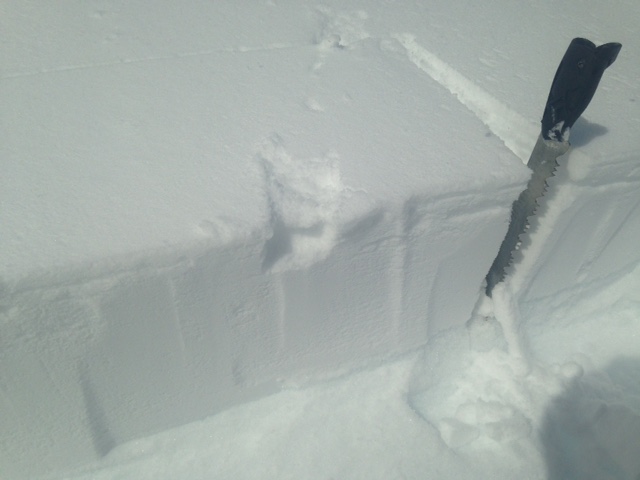
Left - Wind slab on a southeast aspect on 2.28.15 (N.Meyers)
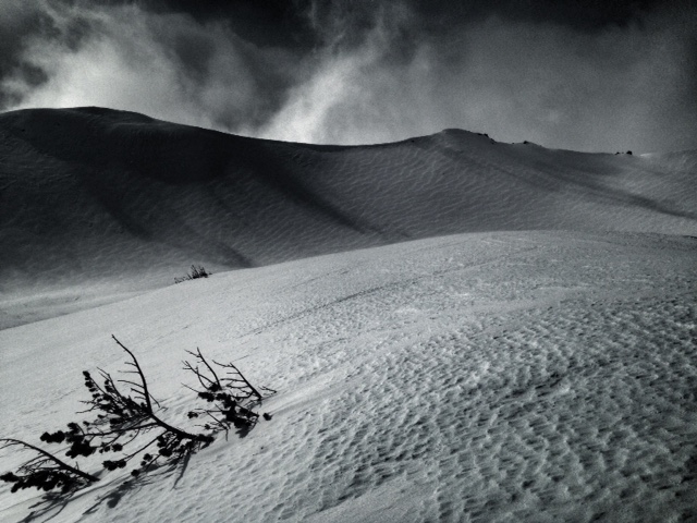
Right - Generally scoured conditions for many areas exposed to wind. Ridgeline in background wind loaded, east/southeast facing. (N.Meyers)
Castle Lake and Mt Eddy zones are still hosting shallow snowpacks. All areas below about 6,000 feet in the forecast area are hosting patchy snow with dirt showing around trees and in sunny spots.
Report your observations to the MSAC! A photo, a few words... send them in! (nimeyers@fs.fed.us or 530-926-9614)
Castle Lake area has a shallow snowpack. Skiing is out of the question at this point due to lack of snow.
Sand Flat Winter Trails: OPEN, trail conditions are firm and getting thin with some tree debris on snow surface.
Pilgrim Creek Snowmobile Park: OPEN, however due to lack of low elevation snow, one must drive up the road several miles before enough snow is encountered. One CANNOT DRIVE over Military Pass. Snowmobiling is not recommended due to low snow depths.
-------------------------------------------------------------------------------------------------------------------------------
Terrain: Remember most of the terrain that we like to play on is greater than 30 degrees. Avalanches are possible on anything steeper than 30 degrees. Avoid cornices, rock bands, terrain traps and runout zones of avalanche paths.
Weather: Most of our areas avalanche danger will occur 24-48 hours after a storm. We still can see persistent weak layers from time to time and we always will be sure to let you know about that! Heed the basic signs: Wind (significant snow transport and depositions), Temperature (rain/snow/rain/snow, which in turn weakens the snowpack), and Precipitation (Snow or rain add weight and stress to the current snowpack).
Snowpack: If snow accumulates, give the snowpack a chance to adjust to the new snow load before you play on or near steep slopes (greater than 30 degrees). Most direct action avalanches occur within 24-48 hours of recent snowfall. Watch for obvious signs of snowpack instability such as recent natural avalanche activity, collapsing of the snowpack (often associated with a “whumphing” sound), and shooting cracks. If you see these signs of instability, limit your recreation to lower angle slopes.
Human Factor: Don’t forget to carry and know how to use avalanche rescue gear. You should NOT be skiing or climbing potential avalanche slopes without having beacons, shovels, and probes. Only one person in a group should be exposed to potential avalanche danger at a time. Remember, climbing, skiing, and riding down the edge of slopes is safer than being in the center. Just because another person is on a slope doesn’t mean that it is safe. Be an individual! Make your own decisions. Heed the signs of instability: rapid warming, “whumphing” noises, shooting cracks, snowing an inch an hour or more, rain, roller balls, wind loading, recent avalanche activity.
The Five Red Flags of Avalanche Danger any time of year include: 1) Recent/current avalanche activity 2) Whumpfing sounds or shooting cracks 3) Recent/current heavy snowfall 4) Strong winds transporting snow 5) Rapid warming or rain on snow.
Weather and Current Conditions
Weather Summary
In Mt Shasta City this morning at 0500, we have mostly clear skies and a current temperature of 30 F degrees.
WEATHER STATION INFORMATION (0500hrs):
On Mt Shasta (South Side) in the last 24 hours...
Old Ski Bowl - 7,600 feet, the current temperature is 16 F. We have received .02 inches of water in the last 24 hours and about 1 inch of new snow at the Old Ski Bowl station. Snow on the ground totals 91 inches with 1-2 inches settlement. Temperatures in the last 24 hours have ranged from 16 F to 29 F.
Gray Butte - 8,000 feet, The current temperature is 19 F and temps have ranged from 18 F to 25 F in the last 24 hours. Winds have been light and variable up until 2100 last night. Since then, winds have averaged 20-30 mph, northeast, with max gusts hitting 42 mph.
Castle Lake and Mt Eddy (West side of Interstate-5)...
Castle Lake - 5,600 feet, the current temperature is 24 F. Temps have ranged from 22 F to 33 F in the last 24 hours. New snow in the last 24 hours totals .5-1 inch with 1 inch settlement. The Castle Lake area has overall a patchy 9-10 inches of snow on the ground.
Mt Eddy - 6,500 feet, the current temperature is 16 F. Temps have ranged from 16 F to 30 F in the last 24 hours. Current snow depth is 29 inches with 1 inch settlement and .5-1 inches new snow in the last 24 hours. Winds have averaged 2 mph, with gusts to 12 mph, southerly.
WEATHER SYNOPSIS: Temperatures are cooler this morning and will bring a crisp sunny day to the area. Winds have picked up out of the east / northeast this morning... we will see lighter wind speeds below and near treeline, however over the next few days, above treeline winds will increase and shift back to more northerly by Tuesday. One last blip of weather will squeeze through Monday morning bringing some light snow showers to the mountain. This is nothing to get excited about... only .04 inches of precip expected and thus maybe a dusting of fresh snow. For the week, warming temperatures, sun and beautiful blue skies will be a good bet! Have a good one...
THIS SEASON: Since October 1st (the wet season) , we have received 30.16 inches of water, normal is 29.50 inches, putting us at 102% of normal. For the month of February, we sit at 10.16 inches of water, normal is 7.23, putting us at 140% of normal. For the year of 2015, we've received 10.64 inches water, normal is 14.29, equalling 74% of normal.
Looking back into 2014, Mt Shasta finished off with 34.36 inches of water with normal being 43.21 inches, leaving us at 79% of normal for the year. For the month of December, Mt Shasta finished at 163% of normal, receiving 12.83 inches of water, normal is 7.85 inches.
Always check the weather before you attempt to climb Mt Shasta. Further, monitor the weather as you climb. Becoming caught on the mountain in any type of weather can compromise life and limb. Be prepared.
| 0600 temperature: | 16 |
| Max. temperature in the last 24 hours: | 29 |
| Average wind direction during the last 24 hours: | Northeast |
| Average wind speed during the last 24 hours: | 0-5 mph/variable until 2100, then 20-30 mph/NE mi/hr |
| Maximum wind gust in the last 24 hours: | 42 mi/hr |
| New snowfall in the last 24 hours: | 0-1 inches |
| Total snow depth: | 91 inches |
Two Day Mountain Weather Forecast
Produced in partnership with the Medford NWS
| For 7000 ft to 9000 ft | |||
|---|---|---|---|
|
Sunday (4 a.m. to 10 p.m.) |
Sunday Night (10 p.m. to 4 a.m.) |
Monday (4 a.m. to 10 p.m.) |
|
| Weather | Sunny | Increasing clouds | Increasing cloudys, chance of snow |
| Temperature (°F) | 39 | 26 | 37 |
| Wind (mi/hr) | Northeast/East 5-10 mph | Variable 0-5 mph | Northerly 5-10 mph |
| Precipitation SWE / Snowfall (in) | / 0 | / 0 | / 0 |
| For 9000 ft to 11000 ft | |||
| Sunday | Sunday Night | Monday | |
| Weather | Sunny | Increasing clouds | Increasing clouds, chance of snow |
| Temperature (°F) | 38 | 17 | 35 |
| Wind (mi/hr) | East/Northeast 15-25 mph with gusts higher, wind chill -6 | North/Northwest 0 | Northerly 10-20 mph with gusts higher |
| Precipitation SWE / Snowfall (in) | / 0 | / 0 | / 0 |

