

You are here
Avalanche Advisory for 2015-03-14 06:40:24
- EXPIRED ON March 15, 2015 @ 6:40 amPublished on March 14, 2015 @ 6:40 am
- Issued by Nick Meyers - Shasta-Trinity National Forest
Bottom Line
The avalanche danger is LOW for all elevations and aspects.
Normal caution advised.
Climbers should be heads up for ice fall, "slide for life" conditions and very strong southwesterly winds this weekend, near and above treeline.


Avalanche Problem 1: Normal Caution
-
Character ?

-
Aspect/Elevation ?
-
Likelihood ?CertainVery LikelyLikelyPossible
 Unlikely
 -
Size ?HistoricVery LargeLargeSmall

Warm temperatures continue today, however increasing clouds will keep wet loose related instabilities at bay. A storm moves into the area tonight with very strong south/southwest winds near and above treeline. While new snow totals are not predicted to be more than a couple inches, wind transport could create wind drifts and slabs on leeward aspects tomorrow.
Recent Observations
The mountain received a couple inches of new snow, deposited smooth-as-a-babies bottom due to light wind speeds on top of our 85 inch, rock solid base on 3-11-15. Snow levels with this storm were generally above 8,000 feet though snow fell down to 6,500 to 7,000. From Bunny Flat to treeline, a skiff of snow was recorded and it wasn't until near and above treeline areas that measurable snow was encountered. This storm was followed by a couple very warm days and it continues to be downright balmy today. These warm temps created some snow surface instabilities in the form of rollerballs and donut rolls on many easterly, southerly and some westerly aspects (8,000 to 9,500 feet), but from our observations, none were able to gather enough mass to cause concern. The new snow has consolidated and bonded well in response to sunny and warm days since the storm. Overall, new snow occumulation did not provide enough material to form significant slabs on top of old snow surfaces. Some extreme north facing slopes near treeline are still hosting dryer snow with shallow wind slabs, but stability tests did not indicate unstable conditions for said slabs. Below treeline, tree wells are showing and dirty snow exists. March isn't over yet and many are still holding out for a couple more good storms this season!
For all users, LOW danger exists and normal caution is advised. Continue to always use safe travel methods: carry situational awareness on your skin up the mountain, choose safe routes and watch for what others are doing, ski one at a time, stop in safe zones!
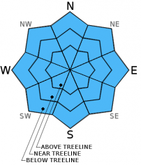
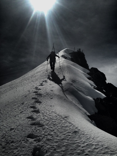
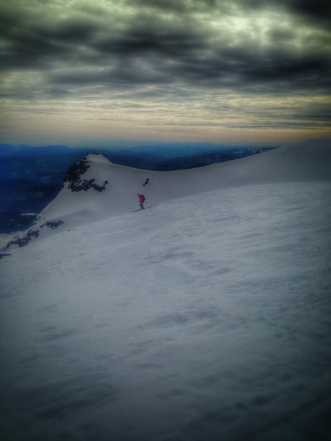
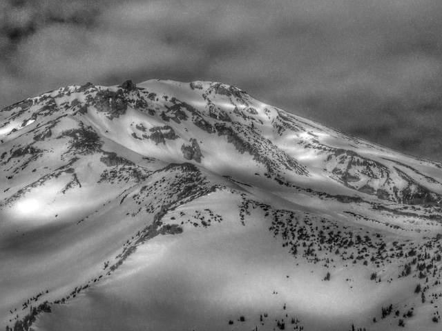
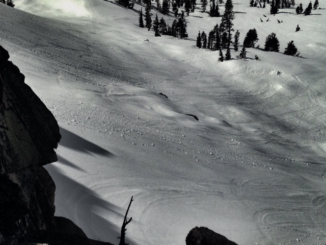
All photos from N Meyers on 3.13.15, clockwise from top left:
*The Doc, deep in the heart of the Mt Shasta backcountry
*Old Ski Bowl ski
*Some roller ball evidence on a southwest/west facing slope
*A great look at Sargents Ridge and The East Side of Mt Shasta
For folks that plan on climbing Mt. Shasta: Route conditions on Casaval Ridge, Sargents Ridge, and Avalanche Gulch are currently good. That being said, there are some objective hazards to be noted. Snow surfaces will be firm and smooth in the early morning hours and will make for "slide for life" conditions. Should one slip and fall and are unable to self-arrest, a long tumble is a possibility. Ice fall from rime ice that still partially covers the Red Banks and other rock outcroppings is happening, even in the early morning hours. A helmet, crampons, and a mountain axe are necessary equipment and should be used.
Castle Lake and Mt Eddy zones are still hosting a shallow snowpack. All areas below about 6,000 feet in the forecast area are hosting patchy snow with dirt showing around trees and in sunny spots. For Castle Lake, skiing is out of the question at this point due to lack of snow.
Report your observations to the MSAC! A photo, a few words... send them in! (nimeyers@fs.fed.us or 530-926-9614)
Sand Flat Winter Trails: OPEN, trail conditions are firm and getting thin with some tree debris on snow surface.
Pilgrim Creek Snowmobile Park: OPEN, however due to lack of low elevation snow, one must drive up the road several miles before enough snow is encountered. One CANNOT DRIVE over Military Pass. Snowmobiling is not recommended due to low snow depths.
-------------------------------------------------------------------------------------------------------------------------------
Terrain: Remember most of the terrain that we like to play on is greater than 30 degrees. Avalanches are possible on anything steeper than 30 degrees. Avoid cornices, rock bands, terrain traps and runout zones of avalanche paths.
Weather: Most of our areas avalanche danger will occur 24-48 hours after a storm. We still can see persistent weak layers from time to time and we always will be sure to let you know about that! Heed the basic signs: Wind (significant snow transport and depositions), Temperature (rain/snow/rain/snow, which in turn weakens the snowpack), and Precipitation (Snow or rain add weight and stress to the current snowpack).
Snowpack: If snow accumulates, give the snowpack a chance to adjust to the new snow load before you play on or near steep slopes (greater than 30 degrees). Most direct action avalanches occur within 24-48 hours of recent snowfall. Watch for obvious signs of snowpack instability such as recent natural avalanche activity, collapsing of the snowpack (often associated with a “whumphing” sound), and shooting cracks. If you see these signs of instability, limit your recreation to lower angle slopes.
Human Factor: Don’t forget to carry and know how to use avalanche rescue gear. You should NOT be skiing or climbing potential avalanche slopes without having beacons, shovels, and probes. Only one person in a group should be exposed to potential avalanche danger at a time. Remember, climbing, skiing, and riding down the edge of slopes is safer than being in the center. Just because another person is on a slope doesn’t mean that it is safe. Be an individual! Make your own decisions. Heed the signs of instability: rapid warming, “whumphing” noises, shooting cracks, snowing an inch an hour or more, rain, roller balls, wind loading, recent avalanche activity.
The Five Red Flags of Avalanche Danger any time of year include: 1) Recent/current avalanche activity 2) Whumpfing sounds or shooting cracks 3) Recent/current heavy snowfall 4) Strong winds transporting snow 5) Rapid warming or rain on snow.
Weather and Current Conditions
Weather Summary
In Mt Shasta City this morning at 0500, we have cloudy skies and a current temperature of 55 F degrees.
WEATHER STATION INFORMATION (0500hrs):
On Mt Shasta (South Side) in the last 24 hours...
Old Ski Bowl - 7,600 feet, the current temperature is 41 F. Snow on the ground totals 85 inches, no new snow and little settlement. Temperatures have ranged from 38 F to 51 F.
Gray Butte - 8,000 feet, The current temperature is 39 F and temps have ranged from 35 F to 48 F in the last 24 hours. Winds have been westerly in direction, averaging 10-20 mph with max gusts to 28 mph, WNW.
Castle Lake and Mt Eddy (West side of Interstate-5)...
Castle Lake - 5,600 feet, the current temperature is 43 F. Temps have ranged from 41 F to 60 F in the last 24 hours. The Castle Lake area has a patchy 6-8 inches of snow on the ground and no new snow during this last storm.
Mt Eddy - 6,500 feet, the current temperature is 41 F. Temps have ranged from 39 F to 52 F in the last 24 hours. Current snow depth is 25 inches with 1-2 inches settlement. Winds have averaged 1-2 mph SW, with gusts to 16 mph, south.
WEATHER SYNOPSIS: A large plume of subtropical moisture extends from below the Hawaiian islands northeast to the Paific Coast. While impressive looking, this front will remain mostly offshore and the associated precip with this storm will be focused north of the area. We won't remain high and dry, but this isn't going to be our Miracle March storm we've all been hoping for. The Mt Shasta area can expect precipitation to start later today and tonight with the brunt of the water falling late tonight and Sunday morning. Temps are warm, and thus driving snow levels during the beginning of the storm to 9,000 to 10,000 feet. By the end of the storm, we should see snow levels drop to 7,000 to 8,000 feet, however by then we'll see just some lingering showers. Wind will be a big theme this weekend and one can expect west/southwest winds to crescendo, 30-40 mph at exposed, mid mountain levels today, 40-50 mph tomorrow, with gusts into the 60 mph range.
THIS SEASON PRECIPITATION: Since October 1st (the wet season) , we have received 30.25 inches of water, normal is 32.59 inches, putting us at 92% of normal. For the month of March, we sit at 0.09 inches of water, normal is 3.09, putting us at 2% of normal. For the year of 2015, we've received 10.73 inches water, normal is 17.38, equalling 61% of normal.
Always check the weather before you attempt to climb Mt Shasta. Further, monitor the weather as you climb. Becoming caught on the mountain in any type of weather can compromise life and limb. Be prepared.
| 0600 temperature: | 41 |
| Max. temperature in the last 24 hours: | 51 |
| Average wind direction during the last 24 hours: | Westerly |
| Average wind speed during the last 24 hours: | 10-20 mph mi/hr |
| Maximum wind gust in the last 24 hours: | 28 mi/hr |
| New snowfall in the last 24 hours: | 0 inches |
| Total snow depth: | 85 inches |
Two Day Mountain Weather Forecast
Produced in partnership with the Medford NWS
| For 7000 ft to 9000 ft | |||
|---|---|---|---|
|
Saturday (4 a.m. to 10 p.m.) |
Saturday Night (10 p.m. to 4 a.m.) |
Sunday (4 a.m. to 10 p.m.) |
|
| Weather | Mostly cloudy, chance of rain, rain likely in the evening | Rain | Rain likely, cloudy |
| Temperature (°F) | 51 | 38 | 45 |
| Wind (mi/hr) | South 10-20 mph | South 10-20 mph | South 15-20 mph |
| Precipitation SWE / Snowfall (in) | / 0 | / .25-.5" rain | / .1-.25" rain |
| For 9000 ft to 11000 ft | |||
| Saturday | Saturday Night | Sunday | |
| Weather | Mostly cloudy, chance of rain and snow | Rain and snow | Snow, cloudy |
| Temperature (°F) | 49 | 32 | 42 |
| Wind (mi/hr) | Southwest 30-40 mph average, gusts to 50-60 mph | South/southwest 0 | South/southwest 40-50 mph with gusts 60-70 mph in exposed areas |
| Precipitation SWE / Snowfall (in) | / 0 | / 2-4 | / 1-3 |

