

You are here
Avalanche Advisory for 2015-03-20 06:10:27
- EXPIRED ON March 21, 2015 @ 6:10 amPublished on March 20, 2015 @ 6:10 am
- Issued by Nick Meyers - Shasta-Trinity National Forest
Bottom Line
The avalanche danger is LOW for all elevations and aspects.
Normal caution advised.
Climbers should be heads up for ice fall and "slide for life" conditions.
Carry a beacon shovel and probe. Wear a helmet. Know how to use your ice axe and crampons.


Avalanche Problem 1: Normal Caution
-
Character ?

-
Aspect/Elevation ?
-
Likelihood ?CertainVery LikelyLikelyPossible
 Unlikely
 -
Size ?HistoricVery LargeLargeSmall

Low danger exists for today.
If you plan on heading up onto the mountain this weekend, expect cooling temperatures and winter weather. Snow with southerly wind will cause the avalanche danger to rise in the next few days.
Recent Observations
The birds are chirping, bugs are hatching and flowers are blossoming...sounds like Spring to me, but no, we are not giving up on Old Man Winter yet! This weekend is hopefully case and point. Two waves of weather will move across the Mt Shasta area this weekend bringing gradually decreasing snow levels and increasing precip amounts with a short break in the middle.
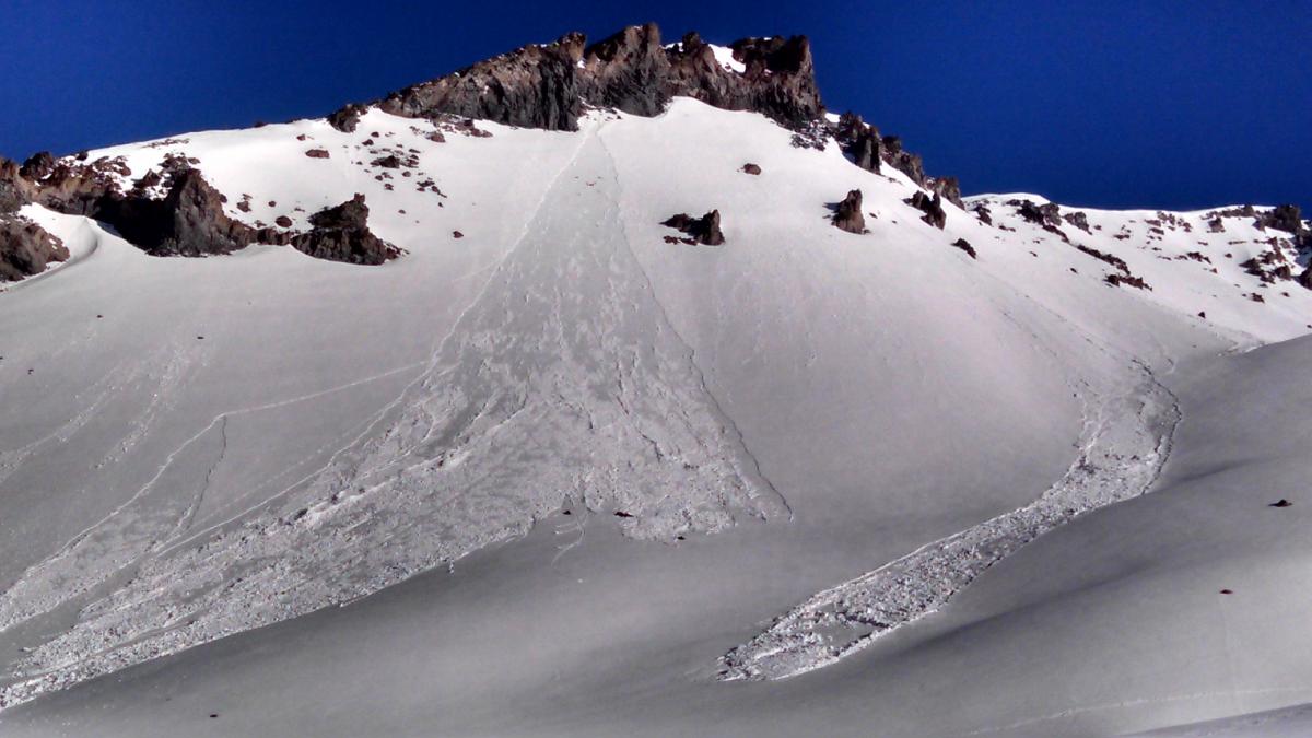
Over the week, we saw fairly widespread natural and some human triggered wet loose point releases on many east, south and west aspects. Knowbody was caught or injured that we heard of. Snow levels with the past weekends storm rose to almost 11,000 feet at times, thus all areas below, near and above treeline received rain on snow. Top layers of the snowpack were very saturated and wet loose point releases occured within new snow layers on top of old snow during the beginning of the week. Only a couple inches was recorded from the storm with 3-4 inches of settlement over the week.
Photos:
Top - Casaval Ridge 3-18-15 [Bob Hutcheson]
Bottom - Wet/loose point releases, photo taken on 3-18 however slides occured earlier in the week, late Sunday/Monday. [Bob Hutcheson]
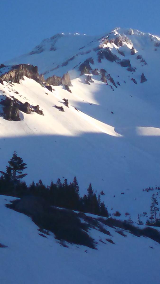
The snowpack is currently in a transitional phase: From 7,000 to about 8,500/9,000 feet, smooth, supportable melt/freeze snow can be found on warmer aspects, east and south. From +/- 8,500 feet and above, the snowpack is still transitioning and thus skiing conditions are a little funky, but not bad. Cooling temperatures over the week will prevent any wet loose activity. The danger is currently low, however keep your antennas up as we get new snow and wind this weekend.
Below treeline, tree wells are showing and dirty snow exists. On the upper mountain, a report from mid-week noted 6 to 12 inches of dryer powder on the old, firm snow on a north facing slope. "Conditions were exhausting..." he noted! The Catwalk on Casaval ridge is narrow with one short section of exposed ice.
Continue to always use safe travel methods: carry situational awareness on your skin up the mountain, choose safe routes and watch for what others are doing, ski one at a time, stop in safe zones!
For folks that plan on climbing Mt. Shasta: Route conditions on Casaval Ridge, Sargents Ridge, and Avalanche Gulch are currently good. That being said, there are some objective hazards to be noted. Snow surfaces will be firm and smooth in the early morning hours and will make for "slide for life" conditions. Should one slip and fall and are unable to self-arrest, a long tumble is a possibility. Ice fall from rime ice that still partially covers the Red Banks and other rock outcroppings is happening, even in the early morning hours. A helmet, crampons, and a mountain axe are necessary equipment and should be used.
Castle Lake and Mt Eddy zones are still hosting a shallow snowpack. All areas below about 6,000 feet in the forecast area are hosting patchy snow with dirt showing around trees and in sunny spots. For Castle Lake, skiing is out of the question at this point due to lack of snow.
Report your observations to the MSAC! A photo, a few words... send them in! (nimeyers@fs.fed.us or 530-926-9614)
Sand Flat Winter Trails: OPEN, however snow depths are meager and the Lower Sand Flat road is exposed dirt. We recommend heading up to Bunny Flat and touring up the road or anywhere higher in elevation!
Pilgrim Creek Snowmobile Park: CLOSED due to lack of snow
-------------------------------------------------------------------------------------------------------------------------------
Terrain: Remember most of the terrain that we like to play on is greater than 30 degrees. Avalanches are possible on anything steeper than 30 degrees. Avoid cornices, rock bands, terrain traps and runout zones of avalanche paths.
Weather: Most of our areas avalanche danger will occur 24-48 hours after a storm. We still can see persistent weak layers from time to time and we always will be sure to let you know about that! Heed the basic signs: Wind (significant snow transport and depositions), Temperature (rain/snow/rain/snow, which in turn weakens the snowpack), and Precipitation (Snow or rain add weight and stress to the current snowpack).
Snowpack: If snow accumulates, give the snowpack a chance to adjust to the new snow load before you play on or near steep slopes (greater than 30 degrees). Most direct action avalanches occur within 24-48 hours of recent snowfall. Watch for obvious signs of snowpack instability such as recent natural avalanche activity, collapsing of the snowpack (often associated with a “whumphing” sound), and shooting cracks. If you see these signs of instability, limit your recreation to lower angle slopes.
Human Factor: Don’t forget to carry and know how to use avalanche rescue gear. You should NOT be skiing or climbing potential avalanche slopes without having beacons, shovels, and probes. Only one person in a group should be exposed to potential avalanche danger at a time. Remember, climbing, skiing, and riding down the edge of slopes is safer than being in the center. Just because another person is on a slope doesn’t mean that it is safe. Be an individual! Make your own decisions. Heed the signs of instability: rapid warming, “whumphing” noises, shooting cracks, snowing an inch an hour or more, rain, roller balls, wind loading, recent avalanche activity.
The Five Red Flags of Avalanche Danger any time of year include: 1) Recent/current avalanche activity 2) Whumpfing sounds or shooting cracks 3) Recent/current heavy snowfall 4) Strong winds transporting snow 5) Rapid warming or rain on snow.
Weather and Current Conditions
Weather Summary
In Mt Shasta City this morning at 0500, we have clear skies and a current temperature of 35 F degrees.
WEATHER STATION INFORMATION (0500hrs):
On Mt Shasta (South Side) in the last 24 hours...
Old Ski Bowl - 7,600 feet, the current temperature is 38 F. Snow on the ground totals 81 inches, no new snow and 3 inches settlement since last Sunday. Temperatures have ranged from 37 F to 53 F.
Gray Butte - 8,000 feet, The current temperature is 40 F and temps have ranged from 40 F to 52 F in the last 24 hours. Winds have been primarily northwest in direction, averaging 5-10 mph with max gusts to 21 mph, NW.
Castle Lake and Mt Eddy (West side of Interstate-5)...
Castle Lake - 5,600 feet, the current temperature is 44 F. Temps have ranged from 41 F to 57 F in the last 24 hours. The Castle Lake area has a patchy very little if any snow left on the ground.
Mt Eddy - 6,500 feet, the current temperature is 39 F. Temps have ranged from 31 F to 52 F in the last 24 hours. Current snow depth is 21 inches with 4 inches settlement since last Sunday. Winds have averaged 2-4 mph WSW, with gusts to 8 mph, east.
WEATHER SYNOPSIS: We are entering into a period of wintery weather this weekend! Two systems will push through - the first will enter today and later tonight and will be the smaller of the two storms. While temps are cooler than they have been, snow levels will still remain between 7,000 and 8,000 feet with .10 inches of water expected, so a skiff of snow on the mountain by tomorrow. A partial clearing will ensure for Saturday... clouds will increase again on Sunday when the second wave is predicted to arrive. This one will bring close to an inch of water with snow levels much lower than we've seen as cold air pushes down over the weekend - as low as 4,000 foot freezing levels by Monday. For both of these systems, south/southwest wind will be a factor, primarily above treeline. Expect averages to be 20-30 mph at times with gusts higher.
THIS SEASON PRECIPITATION: Since October 1st (the wet season) , we have received 30.84 inches of water, normal is 33.72 inches, putting us at 91% of normal. For the month of March, we sit at 0.68 inches of water, normal is 4.22, putting us at 16% of normal. For the year of 2015, we've received 11.32 inches water, normal is 18.51, equalling 61% of normal.
Snow Survey Results for March 2015 for the Sacramento, Shasta and Trinity Watersheds: 49% of normal with at average depth of 37 inches. Historic average for snow is 76.8 inches. Last year at this time we were 36% of normal. Similar years to this year are 1936, 1977, 1988, 1994.
Always check the weather before you attempt to climb Mt Shasta. Further, monitor the weather as you climb. Becoming caught on the mountain in any type of weather can compromise life and limb. Be prepared.
| 0600 temperature: | 38 |
| Max. temperature in the last 24 hours: | 53 |
| Average wind direction during the last 24 hours: | West/Northwest |
| Average wind speed during the last 24 hours: | 5-10 mi/hr |
| Maximum wind gust in the last 24 hours: | 21 mi/hr |
| New snowfall in the last 24 hours: | 0 inches |
| Total snow depth: | 81 inches |
Two Day Mountain Weather Forecast
Produced in partnership with the Medford NWS
| For 7000 ft to 9000 ft | |||
|---|---|---|---|
|
Friday (4 a.m. to 10 p.m.) |
Friday Night (10 p.m. to 4 a.m.) |
Saturday (4 a.m. to 10 p.m.) |
|
| Weather | Partly sunny | Mostly cloudy, chance of rain after 11pm. Chance of precipitation 50% | Slight chance of rain and snow showers, partly sunny |
| Temperature (°F) | 49 | 31 | 44 |
| Wind (mi/hr) | South 5-10 mph | South 10-20 mph | South 5-10 mph |
| Precipitation SWE / Snowfall (in) | / 0 | / 0- .10 | / 0 |
| For 9000 ft to 11000 ft | |||
| Friday | Friday Night | Saturday | |
| Weather | Partly sunny, windy | 50% chance of snow after 11pm, mostly cloudy | 20% chance of snow showers. Partly sunny. |
| Temperature (°F) | 50 | 28 | 44 |
| Wind (mi/hr) | Southwest 20-30 mph, gusts higher | Southwest 0 | West/Southwest 30-40 mph |
| Precipitation SWE / Snowfall (in) | / 0 | / 1-2 | / 0 |

