

You are here
Avalanche Advisory for 2015-03-29 06:41:54
- EXPIRED ON March 30, 2015 @ 6:41 amPublished on March 29, 2015 @ 6:41 am
- Issued by Jon Dove - Shasta-Trinity National Forest
Bottom Line
The avalanche danger will continue to be LOW for all elevations and aspects. The possibility for loose wet snow instabilities, roller balls, and pin wheels on steeper S-SE-E aspects remains today. Slides large enough to bury a person are unlikely, however, they can knock one off their feet and push them into undesirable terrain. Normal caution is advised.
Carry a beacon shovel and probe. Wear a helmet. Know how to use your ice axe and crampons.


Avalanche Problem 1: Normal Caution
-
Character ?

-
Aspect/Elevation ?
As temperatures cool this week the possibility of any loose wet snow instabilities will diminish. The chance of precipitation on Tuesday and Wednesday will only be a factor if measurable amounts of snow are produced. Models only predict a scant amount of water which may only produce an inch or two of snow. Otherwise, firm and smooth snow conditions will exist on all elevations and aspects. For climbers this presents "slide for life" conditions if one were to fall and are unable to self-arrest. An ice axe, crampons, and helmet are necessary equipment. Know how to use them!
Recent Observations
Good corn snow conditions have been in ample abundance this weekend making for great spring skiing and riding. Slightly cooler temperatures yesterday only slightly delayed softening of snow. Temperatures warm by a few degrees today, and by a few more degrees on Monday before falling by close to 20 degrees on Tuesday. More seasonally accurate temperatures will continue through the remainder of the week. The drop in temperatures to a more seasonal norm will be accompanied with a chance of precipitation on Tuesday and Wednesday. Snow levels will drop to 4000 feet by Wednesday, however, water amounts contained in this system will be light at less than a tenth of an inch forecast. Winds will be a concern starting Monday night into Tuesday with speeds of 35-50 mph with higher gusts at mid to upper elevations (above 9,ooo feet) coming out of the SW to W. Wednesday will remain breezy, as well. The weather will dry up on Thursday and Friday, but remain cool. These changes in weather for the coming week will affect the snow on Mt. Shasta in a couple of ways. The cooler, more seasonal, temperatures will not allow snow to soften at most elevations and aspect during the day. The cold front forecast for Monday night and Tuesday will come with strong winds that will also prohibit any softening of the snow surface. The prospect of light snow on Wednesday will not do much in the way of adding a substantial new layer of snow. Thin wind slabs may potentially form if new snow accumulates to significant amounts. Look for them on leeward SE-E-NE slopes and other isolated pockets.
A ski tour up into Avalanche Gulch made for a pleasant outing on good corn snow. A descent from 50/50 flat at close to 9,300 feet provided smooth turns in 1-2 inches of wet snow on a supportable base. The snow did get a little sticky in scattered spots below tree line. No loose wet snow instabilities, roller balls, or pin wheels were observed or reported.
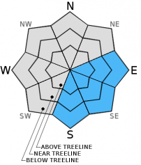
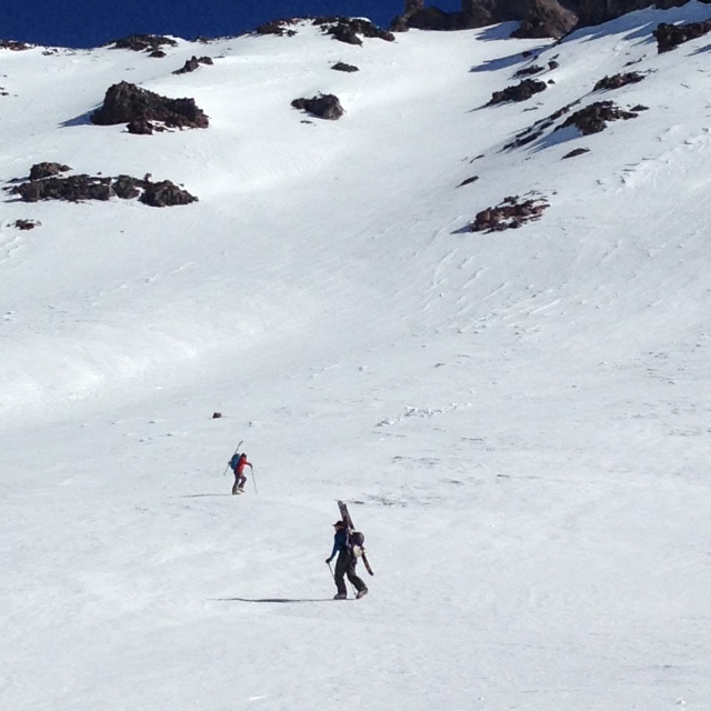
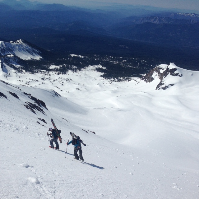
Photos:
Top Left- Forrest and Alyssa below Shastarama chute on ascent 3/27/2015 - Photo: Jon Dove
Top Right- Shay and Alyssa climbing up into the Shastarama chute proper 3/27/2015 - Photo: Jon Dove
Bottom- Forrest dropping in and slaying the corn, top of Shastarama chute 3/27/2015 - Photo: Jon Dove
Continue to always use safe travel methods: carry situational awareness on your skin up the mountain, choose safe routes and watch for what others are doing, ski one at a time, stop in safe zones!
For folks that plan on climbing Mt. Shasta: Route conditions on Casaval Ridge, Sargents Ridge, and Avalanche Gulch are currently good. Snow conditions have made the melt/freeze transition into supportable firm snow at most elevations and aspects. Snow on more northerly facing aspects may host snow that has not fully transitioned yet, and may be a little punchy. This means that boot penetration of a few inches is possible. Firm snow on W-SW-S-SE-E aspects will soften some during the day making for corn snow conditions. Climbers should be advised that the presence of firm, smooth snow means the possibility for a long fall is present. "Slide for life" conditions exist if self-arrest is not achieved immediately! Ice fall from rime ice that has built up on the Red Banks and other rock outcroppings will be happening even in the early morning hours. A helmet, crampons, and a mountain axe are necessary equipment and should be used.
Castle Lake and Mt Eddy zones are still hosting a shallow snowpack. All areas below about 6,000 feet in the forecast area are hosting patchy snow with dirt showing around trees and in sunny spots. For Castle Lake, skiing is out of the question at this point due to lack of snow.
Report your observations to the MSAC! A photo, a few words... send them in! (nimeyers@fs.fed.us or 530-926-9614)
Sand Flat Winter Trails: OPEN, however snow depths are meager and the Lower Sand Flat road is exposed dirt. We recommend heading up to Bunny Flat and touring up the road or anywhere higher in elevation!
Pilgrim Creek Snowmobile Park: CLOSED due to lack of snow
-------------------------------------------------------------------------------------------------------------------------------
Terrain: Remember most of the terrain that we like to play on is greater than 30 degrees. Avalanches are possible on anything steeper than 30 degrees. Avoid cornices, rock bands, terrain traps and runout zones of avalanche paths.
Weather: Most of our areas avalanche danger will occur 24-48 hours after a storm. We still can see persistent weak layers from time to time and we always will be sure to let you know about that! Heed the basic signs: Wind (significant snow transport and depositions), Temperature (rain/snow/rain/snow, which in turn weakens the snowpack), and Precipitation (Snow or rain add weight and stress to the current snowpack).
Snowpack: If snow accumulates, give the snowpack a chance to adjust to the new snow load before you play on or near steep slopes (greater than 30 degrees). Most direct action avalanches occur within 24-48 hours of recent snowfall. Watch for obvious signs of snowpack instability such as recent natural avalanche activity, collapsing of the snowpack (often associated with a “whumphing” sound), and shooting cracks. If you see these signs of instability, limit your recreation to lower angle slopes.
Human Factor: Don’t forget to carry and know how to use avalanche rescue gear. You should NOT be skiing or climbing potential avalanche slopes without having beacons, shovels, and probes. Only one person in a group should be exposed to potential avalanche danger at a time. Remember, climbing, skiing, and riding down the edge of slopes is safer than being in the center. Just because another person is on a slope doesn't’t mean that it is safe. Be an individual! Make your own decisions. Heed the signs of instability: rapid warming, “whumphing” noises, shooting cracks, snowing an inch an hour or more, rain, roller balls, wind loading, recent avalanche activity.
The Five Red Flags of Avalanche Danger any time of year include: 1) Recent/current avalanche activity 2) Whumpfing sounds or shooting cracks 3) Recent/current heavy snowfall 4) Strong winds transporting snow 5) Rapid warming or rain on snow.
Weather and Current Conditions
Weather Summary
In Mt Shasta City this morning at 0500, we have clear skies and a current temperature of 43 F degrees. Winds are calm.
WEATHER STATION INFORMATION (0500hrs):
On Mt Shasta (South Side) in the last 24 hours...
Old Ski Bowl - 7,600 feet, the current temperature is 38 F. Snow on the ground totals 80 inches with 2 inches settlement since yesterday. Temperatures have ranged from 32 F to 49 F.
Gray Butte - 8,000 feet, the current temperature is 40 F. Temps have ranged from 36 F to 46 F. Winds have been variable in direction, averaging 8 mph with gusts to 42 mph, NNW.
Castle Lake and Mt Eddy (West side of Interstate-5)...
Castle Lake - 5,600 feet, the current temperature is 42 F. Temps have ranged from 29 F to 52 F. The Castle Lake area has very little snow left on the ground.
Mt Eddy - 6,500 feet, the current temperature is 40 F. Temps have ranged from 35 F to 49 F in the last 24 hours. Current snow depth is 17 inches with 1 inch settlement. Winds have been averaging 2 mph with gusts to 12 mph, ESE.
WEATHER SYNOPSIS: High pressure will continue to be the ruling force directing the weather through Monday. Monday night through Tuesday a cold front will herald a major change in the weather with temperatures falling by close to 20 degrees on Tuesday. This will bring temperatures from the above normal level to something that is closer to early spring norms. These cooler, more seasonal temperatures will persist through the remainder of the week. This cold front will also bring the chance of some precipitation to the area on Tuesday and Wednesday. Models only predict measurable amounts of water on Wednesday, however, at slightly less than a tenth of an inch. Winds will be heavy as the front passes Monday night and Tuesday coming out of the SW to W at 35-50 mph. Winds will stay breezy on Wednesday as well as remaining cool. Things dry up on Thursday and Friday with a chance of overnight frost in valley bottoms.
THIS SEASON PRECIPITATION: Since October 1st (the wet season) , we have received 31.43 inches of water, normal is 35.07 inches, putting us at 89% of normal. For the month of March, we sit at 1.27 inches of water, normal is 5.57, putting us at 22% of normal. For the year of 2015, we've received 11.91 inches water, normal is 19.86, equalling 59% of normal.
Snow Survey Results for March 2015 for the Sacramento, Shasta and Trinity Watersheds: 49% of normal with at average depth of 37 inches. Historic average for snow is 76.8 inches. Last year at this time we were 36% of normal. Similar years to this year are 1936, 1977, 1988, 1994.
Always check the weather before you attempt to climb Mt Shasta. Further, monitor the weather as you climb. Becoming caught on the mountain in any type of weather can compromise life and limb. Be prepared.
| 0600 temperature: | 38 |
| Max. temperature in the last 24 hours: | 49 |
| Average wind direction during the last 24 hours: | Variable |
| Average wind speed during the last 24 hours: | 8 mph mi/hr |
| Maximum wind gust in the last 24 hours: | 42 mph mi/hr |
| New snowfall in the last 24 hours: | 0 inches |
| Total snow depth: | 80 inches |
Two Day Mountain Weather Forecast
Produced in partnership with the Medford NWS
| For 7000 ft to 9000 ft | |||
|---|---|---|---|
|
Sunday (4 a.m. to 10 p.m.) |
Sunday Night (10 p.m. to 4 a.m.) |
Monday (4 a.m. to 10 p.m.) |
|
| Weather | Mostly sunny | Partly Cloudy | Mostly sunny |
| Temperature (°F) | 61 | 40 | 63 |
| Wind (mi/hr) | North 5-10 mph | North Around 5 mph | Southeast shifting to Southwest in the afternoon 10-15 mph |
| Precipitation SWE / Snowfall (in) | / 0 | / 0 | / 0 |
| For 9000 ft to 11000 ft | |||
| Sunday | Sunday Night | Monday | |
| Weather | Mostly sunny | Partly Cloudy | Mostly sunny |
| Temperature (°F) | 34 | 31 | 34 |
| Wind (mi/hr) | West 20-25 mph with gusts to 35 | Southwest 0 | Southwest 25-30 mph with higher gusts |
| Precipitation SWE / Snowfall (in) | / 0 | / 0 | / 0 |

