

You are here
Avalanche Advisory for 2015-04-04 06:51:57
- EXPIRED ON April 5, 2015 @ 6:51 amPublished on April 4, 2015 @ 6:51 am
- Issued by Jon Dove - Shasta-Trinity National Forest
Bottom Line
The avalanche danger will remain LOW for all elevations and aspects. Firm and smooth "slide for life" snow conditions exist, and present the potential for a long fall if one is unable to self-arrest in the event of a slip. Ice fall and rock fall is a possibility so keep eyes up slope as you climb. Normal caution is advised.
Carry a beacon shovel and probe. Wear a helmet. Know how to use your ice axe and crampons.


Avalanche Problem 1: Normal Caution
-
Character ?

-
Aspect/Elevation ?
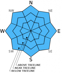
Normal caution advised. Firm and smooth snow conditions will exist on all elevations and aspects. For climbers this presents "slide for life" conditions if one were to fall and are unable to self-arrest. An ice axe, crampons, and helmet are necessary equipment. Know how to use them!
Recent Observations
Winter weather is forecast to return to the area late tonight into Sunday, and avalanche conditions will increase with the addition of significant new snow amounts. The presence of windy conditions at the mid and upper elevations will bring the prospect of wind slab development as well. For today, however, we must endure one more day of dry, partly sunny skies. Temperatures will be warm enough at near and below tree line to soften up the top inch or two of snow and provide for a pleasant Saturday tour. Higher, more exposed terrain above 9,000-9,500 feet will remain too cool and breezy for the snow surface to soften much.
Observations made yesterday on a short ski tour to tree line revealed decent corn snow conditions as the top one to two inches of snow managed to soften providing for good skiing. Reports from other skiers who ventured higher up into Avalanche Gulch stayed consistent with the expected effect of the cooler, more seasonal temperatures on the snow. Most of those I spoke with decided to make 50/50 Flat at 9,300 feet their high point as snow was not softening enough from there on up. No loose wet snow instabilities, roller balls, or pin wheels were observed in any of the usual S-SE-E aspects at elevations low enough for snow to soften.
Reports gathered from climbers who managed to reach the summit yesterday detailed firm snow conditions making for good climbing along the entire length of the Avalanche Gulch route. No rock or ice fall were witnessed.
Continue to always use safe travel methods: carry situational awareness on your skin up the mountain, choose safe routes and watch for what others are doing, ski one at a time, stop in safe zones!
For folks that plan on climbing Mt. Shasta: Route conditions on Casaval Ridge, Sargents Ridge, and Avalanche Gulch are currently good. Snow conditions have made the melt/freeze transition into supportable firm snow on all elevations and aspects. Firm snow on W-SW-S-SE-E aspects above 9,000 feet will not soften much during the day making good corn snow harder to find. Climbers should be advised that the presence of firm, smooth snow means the possibility for a long fall is present. "Slide for life" conditions exist if self-arrest is not achieved immediately! The potential for ice fall and rock fall exists and may be happening even in the early morning hours. A helmet, crampons, and a mountain axe are necessary equipment and should be used.
Castle Lake and Mt Eddy zones are still hosting a shallow snowpack. All areas below about 6,000 feet in the forecast area are hosting patchy snow with dirt showing around trees and in sunny spots. For Castle Lake, skiing is out of the question at this point due to lack of snow.
Report your observations to the MSAC! A photo, a few words... send them in! (nimeyers@fs.fed.us or 530-926-9614)
Sand Flat Winter Trails: OPEN, however snow depths are meager and the Lower Sand Flat road is exposed dirt. We recommend heading up to Bunny Flat and touring up the road or anywhere higher in elevation!
Pilgrim Creek Snowmobile Park: CLOSED due to lack of snow
-------------------------------------------------------------------------------------------------------------------------------
Terrain: Remember most of the terrain that we like to play on is greater than 30 degrees. Avalanches are possible on anything steeper than 30 degrees. Avoid cornices, rock bands, terrain traps and runout zones of avalanche paths.
Weather: Most of our areas avalanche danger will occur 24-48 hours after a storm. We still can see persistent weak layers from time to time and we always will be sure to let you know about that! Heed the basic signs: Wind (significant snow transport and depositions), Temperature (rain/snow/rain/snow, which in turn weakens the snowpack), and Precipitation (Snow or rain add weight and stress to the current snowpack).
Snowpack: If snow accumulates, give the snowpack a chance to adjust to the new snow load before you play on or near steep slopes (greater than 30 degrees). Most direct action avalanches occur within 24-48 hours of recent snowfall. Watch for obvious signs of snowpack instability such as recent natural avalanche activity, collapsing of the snowpack (often associated with a “whumphing” sound), and shooting cracks. If you see these signs of instability, limit your recreation to lower angle slopes.
Human Factor: Don’t forget to carry and know how to use avalanche rescue gear. You should NOT be skiing or climbing potential avalanche slopes without having beacons, shovels, and probes. Only one person in a group should be exposed to potential avalanche danger at a time. Remember, climbing, skiing, and riding down the edge of slopes is safer than being in the center. Just because another person is on a slope doesn't’t mean that it is safe. Be an individual! Make your own decisions. Heed the signs of instability: rapid warming, “whumphing” noises, shooting cracks, snowing an inch an hour or more, rain, roller balls, wind loading, recent avalanche activity.
The Five Red Flags of Avalanche Danger any time of year include: 1) Recent/current avalanche activity 2) Whumpfing sounds or shooting cracks 3) Recent/current heavy snowfall 4) Strong winds transporting snow 5) Rapid warming or rain on snow.
Weather and Current Conditions
Weather Summary
In Mt Shasta City this morning at 0500, we have overcast skies and a current temperature of 41 F degrees. Winds to 6 mph, northwesterly.
WEATHER STATION INFORMATION (0500hrs):
On Mt Shasta (South Side) in the last 24 hours...
Old Ski Bowl - 7,600 feet, the current temperature is 29 F. Snow on the ground totals 78 inches with no settlement. Temperatures have ranged from 25 F to 42 F.
Gray Butte - 8,000 feet, the current temperature is 28 F. Temps have ranged from 26 F to 38 F. Winds have been Westerly in direction, averaging 12 mph with gusts to 21 mph, W.
Castle Lake and Mt Eddy (West side of Interstate-5)...
Castle Lake - 5,600 feet, the current temperature is 30 F. Temps have ranged from 30 F to 52 F. The Castle Lake area has very little snow left on the ground.
Mt Eddy - 6,500 feet, the current temperature is 27 F. Temps have ranged from 25F to 42 F in the last 24 hours. Current snow depth is 12 inches with no settlement. Winds have been variable in direction, averaging 2 mph with gusts to 9 mph, ESE.
WEATHER SYNOPSIS: A weak upper trough continues to spread over the area today bringing some mid to high level clouds with the sun poking through. Mt. Shasta will remain dry through the day into tonight. Southwest winds will be light at near and below tree line at 5-10 mph, and will be higher at the mid and upper elevations (above 9,000 feet) at 20-30 mph with higher gusts. An upper level low will begin to drop southward across the region tonight bringing a cool showery pattern through Sunday. Precipitation will begin to fall sometime late Saturday night into early Sunday morning, then tapering off Sunday night. Models forecast 0.57 inches of water by late Sunday night. A pocket of cold air aloft will lead to an unstable air mass and the chance of thunder storms.
THIS SEASON PRECIPITATION: Since October 1st (the wet season) , we have received 31.43 inches of water, normal is 35.81 inches, putting us at 87% of normal. For the month of April, we sit at 0 inches of water, normal is 0.35, putting us at 0% of normal. For the year of 2015, we've received 11.91 inches water, normal is 20.60, equalling 57% of normal.
Snow Survey Results for March 2015 for the Sacramento, Shasta and Trinity Watersheds: 49% of normal with at average depth of 37 inches. Historic average for snow is 76.8 inches. Last year at this time we were 36% of normal. Similar years to this year are 1936, 1977, 1988, 1994.
Always check the weather before you attempt to climb Mt Shasta. Further, monitor the weather as you climb. Becoming caught on the mountain in any type of weather can compromise life and limb. Be prepared.
| 0600 temperature: | 29 |
| Max. temperature in the last 24 hours: | 42 |
| Average wind direction during the last 24 hours: | Westerly |
| Average wind speed during the last 24 hours: | 12 mph mi/hr |
| Maximum wind gust in the last 24 hours: | 21 mph mi/hr |
| New snowfall in the last 24 hours: | 0 inches |
| Total snow depth: | 78 inches |
Two Day Mountain Weather Forecast
Produced in partnership with the Medford NWS
| For 7000 ft to 9000 ft | |||
|---|---|---|---|
|
Saturday (4 a.m. to 10 p.m.) |
Saturday Night (10 p.m. to 4 a.m.) |
Sunday (4 a.m. to 10 p.m.) |
|
| Weather | Partly sunny with increasing clouds in the afternoon | Mostly cloudy, snow showers likely | Cloudy, snow showers with some thunder possible |
| Temperature (°F) | 45 | 21 | 32 |
| Wind (mi/hr) | North shifting to Southwest in the afternoon Around 5 mph | Southwest 5-10 mph with gusts to 20 mph | South 10-15 mph |
| Precipitation SWE / Snowfall (in) | / 0 | / 1-2 inches | / 3-5 inches |
| For 9000 ft to 11000 ft | |||
| Saturday | Saturday Night | Sunday | |
| Weather | Partly sunny with increasing clouds in the afternoon | Mostly cloudy, snow showers likely | Cloudy, snow showers with some thunder possible |
| Temperature (°F) | 21 with wind chill to -5 | 10 with wind chill to -17 | 10 with wind chill to -19 |
| Wind (mi/hr) | Southwest 20-30 mph with higher gusts | Southwest 0 | Southwest 30-40 mph with higher gusts |
| Precipitation SWE / Snowfall (in) | / 0 | / 1-3 inches | / 5-9 inches |

