

You are here
Avalanche Advisory for 2015-04-05 06:33:12
- EXPIRED ON April 6, 2015 @ 6:33 amPublished on April 5, 2015 @ 6:33 am
- Issued by Nick Meyers - Shasta-Trinity National Forest
Bottom Line
The avalanche danger is LOW for all elevations and aspects today, however will rise over the next 48-72 hours.
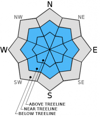
Moderate to Considerable avalanche danger for wind and storm slab avalanches, near and above treeline, is possible as new snow accumulates on our old, firm snowpack. Wide open slopes and bowls above treeline will be the best places for these avalanche problems to be found early this week.
Always carry a beacon, shovel and probe.


Avalanche Problem 1: Wind Slab
-
Character ?

-
Aspect/Elevation ?
-
Likelihood ?CertainVery LikelyLikelyPossible
 Unlikely
 -
Size ?HistoricVery LargeLargeSmall

New snow with south/southwest/west wind will create conditions condusive for wind slab formation. Areas above treeline will see the best chance of hosting wind slabs. Typically south/southwest/west winds will load north/northeast/east and closely associate slopes, however with local orographics and funky terrain orientation on Mt Shasta, other slope aspects not expected can be wind loaded.
If you choose to travel above treeline, keep an eye out for areas of ankle to boot top or deeper slabs/wind drifts near ridgelines along bowls and stay off these areas until the snowpack stabilizes.
Today, the avalanche danger will be low and wind slabs will likely be small and insignificant. Slab formation and associated danger with this avalanche probelm is expected to rise over the next 48-72 hours. Danger could rise to moderate/considerable near and above treeline. Keep this in mind as your late season powder hunt takes place.
Avalanche Problem 2: Storm Slab
-
Character ?

-
Aspect/Elevation ?

-
Likelihood ?CertainVery LikelyLikelyPossible
Unlikely
-
Size ?HistoricVery LargeLargeSmall
New snow accumulation over the next three days is expected to be 1-2 feet on Mt Shasta. Cooler temperatures and a few inches of snow today will be followed by warmer temperatuers and heavy snow tomorrow. This may create "upside down cake effect" storm slabs, with weaker snow below denser, stronger snow. Storm slabs are possible near and above treeline where our firm, old snow exists. Open bowls and wide open terrain where we still have a good snowpack will be the best places to find storm slabs.
The danger today will be low, however will increase to moderate/considerable as new snow accumulates over the next 48-72 hours.
Recent Observations
Conditions have not changed significantly over the weekend. Firm, smooth snow surfaces with limited softening continue today. This will change soon as several storm systems pass over the area beginning this afternoon (see weather section below). These systems are forecasted to give us up to 1.75 inches of precipitation by mid week with snow levels down to Mt Shasta City limits at times. This could mean 1-2 feet of new snow accumulation on the mountain over the next few days. West/Southwest winds will accompany these systems with the highest wind speeds near and above treeline. Wind and storm slab development will take place and the avalanche danger will rise.
We will have to wait and see how new snow bonding to old snow goes... based on predicted temperatures, models are showing this first wave of snow to be cooler, followed by a brief break, and then heavier, warmer snow close behind. This could mean the "upside down cake effect", or heavier (dense) snow on top of lighter (less dense) snow. This is not favorable for good snow stability. Temps are going to warm up a few degrees after the storm, mid-week. Any avalanche danger will likely be during or 24-48 hours after these storm systems.
For folks that plan on climbing Mt. Shasta: All routes on the mountain are currently in great shape, however with incoming new snow, climbing is not advised for the next several days. The avalanche danger is expected to rise with the formation of wind and storm slab avalanches. Post holing will also be a problem where significant accumulation occurs. WInd, extreme wind chill and winter weather will be encountered this week and if one still chooses to make a trip up or on Mt Shasta, be prepared!
Castle Lake and Mt Eddy zones are still hosting a shallow snowpack. All areas below about 6,000 feet in the forecast area are hosting patchy, if any snow with dirt showing around trees and in sunny spots. For Castle Lake, skiing is out of the question at this point due to lack of snow.
Report your observations to the MSAC! A photo, a few words... send them in! (nimeyers@fs.fed.us or 530-926-9614)
Sand Flat Winter Trails: OPEN, however snow depths are meager and the Lower Sand Flat road is exposed dirt. We recommend heading up to Bunny Flat and touring up the road or anywhere higher in elevation!
Pilgrim Creek Snowmobile Park: CLOSED due to lack of snow
-------------------------------------------------------------------------------------------------------------------------------
Terrain: Remember most of the terrain that we like to play on is greater than 30 degrees. Avalanches are possible on anything steeper than 30 degrees. Avoid cornices, rock bands, terrain traps and runout zones of avalanche paths.
Weather: Most of our areas avalanche danger will occur 24-48 hours after a storm. We still can see persistent weak layers from time to time and we always will be sure to let you know about that! Heed the basic signs: Wind (significant snow transport and depositions), Temperature (rain/snow/rain/snow, which in turn weakens the snowpack), and Precipitation (Snow or rain add weight and stress to the current snowpack).
Snowpack: If snow accumulates, give the snowpack a chance to adjust to the new snow load before you play on or near steep slopes (greater than 30 degrees). Most direct action avalanches occur within 24-48 hours of recent snowfall. Watch for obvious signs of snowpack instability such as recent natural avalanche activity, collapsing of the snowpack (often associated with a “whumphing” sound), and shooting cracks. If you see these signs of instability, limit your recreation to lower angle slopes.
Human Factor: Don’t forget to carry and know how to use avalanche rescue gear. You should NOT be skiing or climbing potential avalanche slopes without having beacons, shovels, and probes. Only one person in a group should be exposed to potential avalanche danger at a time. Remember, climbing, skiing, and riding down the edge of slopes is safer than being in the center. Just because another person is on a slope doesn't’t mean that it is safe. Be an individual! Make your own decisions. Heed the signs of instability: rapid warming, “whumphing” noises, shooting cracks, snowing an inch an hour or more, rain, roller balls, wind loading, recent avalanche activity.
The Five Red Flags of Avalanche Danger any time of year include: 1) Recent/current avalanche activity 2) Whumpfing sounds or shooting cracks 3) Recent/current heavy snowfall 4) Strong winds transporting snow 5) Rapid warming or rain on snow.
Weather and Current Conditions
Weather Summary
In Mt Shasta City this morning at 0500, we have cloudy skies and a current temperature of 39 F degrees with calm winds.
WEATHER STATION INFORMATION (0500hrs):
On Mt Shasta (South Side) in the last 24 hours...
Old Ski Bowl - 7,600 feet, the current temperature is 22 F. Snow on the ground totals 77 inches with one inch settlement. Temperatures have ranged from 22 F to 37 F.
Gray Butte - 8,000 feet, the current temperature is 22 F. Temps have ranged from 22 F to 34 F. Winds have been west/southwest in direction, averaging 5-10 mph with gusts to 21 mph, WSW.
Castle Lake and Mt Eddy (West side of Interstate-5)...
Castle Lake - 5,600 feet, the current temperature is 28 F. Temps have ranged from 27 F to 48 F. The Castle Lake area has very little, if any snow left on the ground.
Mt Eddy - 6,500 feet, the current temperature is 26 F. Temps have ranged from 24 F to 36 F. Current snow depth is 8 inches with no settlement. Winds have been easterly in direction, averaging 1-2 mph with gusts to 9 mph, ESE.
WEATHER SYNOPSIS: April SNOW showers bring May flowers...or something like that! Winter is not over yet and the next few days of weather are going to bring some of the season's lowest snow levels and a decent amount of precipitation, we hope. Today, snow showers and a chance of thunder will begin with the heaviest precip expected in the afternoon...snow levels will be as low as 4,000 feet. Winds on the mountain will stay consistently 20-30 mph out of the WSW. We will get a brief break in the systems Sunday night.... close behind and set to arrive on Monday afternoon/evening, times of moderate to heavy precipitation with snow levels down to Mt Shasta City limits. Winds will rise and fall over the next few days, however on the mountain one can still expect consistent WSW winds to blow 15-25 mph with gusts higher. Overall, we should see upwards of 1.5 to 1.75 inches of precip for both storms by late Tuesday, which could mean 1-2 feet of new snow on the mountain by mid week.
THIS SEASON PRECIPITATION: Since October 1st (the wet season) , we have received 31.43 inches of water, normal is 35.92 inches, putting us at 87% of normal. For the month of April, we sit at 0 inches of water, normal is 0.46, putting us at 0% of normal. For the year of 2015, we've received 11.91 inches water, normal is 20.71, equalling 57% of normal.
Snow Survey Results for March 2015 for the Sacramento, Shasta and Trinity Watersheds: 49% of normal with at average depth of 37 inches. Historic average for snow is 76.8 inches. Last year at this time we were 36% of normal. Similar years to this year are 1936, 1977, 1988, 1994.
Always check the weather before you attempt to climb Mt Shasta. Further, monitor the weather as you climb. Becoming caught on the mountain in any type of weather can compromise life and limb. Be prepared.
| 0600 temperature: | 21 |
| Max. temperature in the last 24 hours: | 37 |
| Average wind direction during the last 24 hours: | West/Southwest |
| Average wind speed during the last 24 hours: | 5-10 mi/hr |
| Maximum wind gust in the last 24 hours: | 21 mi/hr |
| New snowfall in the last 24 hours: | 0 inches |
| Total snow depth: | 78 inches |
Two Day Mountain Weather Forecast
Produced in partnership with the Medford NWS
| For 7000 ft to 9000 ft | |||
|---|---|---|---|
|
Sunday (4 a.m. to 10 p.m.) |
Sunday Night (10 p.m. to 4 a.m.) |
Monday (4 a.m. to 10 p.m.) |
|
| Weather | Snow showers, some thunder is possible as well! | Snow showers... tapering off, thunder possible | Snow showers, heavy at times |
| Temperature (°F) | 25 | 19 | 29 |
| Wind (mi/hr) | South 5-15 mph | South/southwest 5-10 mph with gusts to 20 mph | South/southwest 10-15 mph |
| Precipitation SWE / Snowfall (in) | / 3-7 | / 1-3 | / 3-5 |
| For 9000 ft to 11000 ft | |||
| Sunday | Sunday Night | Monday | |
| Weather | Snow showers | Snow showers, tapering off, thunder possible | Snow showers, heavy at times |
| Temperature (°F) | 9 | 8, wind chill to -17 | 13, wind chill to -14 |
| Wind (mi/hr) | Southwest 20-30 mph with higher gusts | West/Southwest 5-9 | South/southwest 30-40 mph with higher gusts |
| Precipitation SWE / Snowfall (in) | / 5-9 | / 2-4 | / 3-7 |

