

You are here
Avalanche Advisory for 2015-04-10 06:47:04
- EXPIRED ON April 11, 2015 @ 6:47 amPublished on April 10, 2015 @ 6:47 am
- Issued by Nick Meyers - Shasta-Trinity National Forest
Bottom Line
The avalanche danger is LOW for below and near treeline areas, all aspects.
While the new snow has shown good bonding and stability, pockets of MODERATE avalanche danger in extreme, steep terrain (>38 degrees) may be encountered above treeline. Dig a pit, identify and test weak layers and make sound judgements.


Avalanche Problem 1: Normal Caution
-
Character ?

-
Aspect/Elevation ?
-
Likelihood ?CertainVery LikelyLikelyPossible
 Unlikely
 -
Size ?HistoricVery LargeLargeSmall

The snowpack has settled up to 13 inches since the storm and shown good stability. Do no rule out the chance of point release slides on cold, shaded northerly aspects in steep, extreme terrain or slab avalanches on all other aspects. Most concern will lie above treeline.
It's advised to dig a pit, identify weak layers and make judgements accordingly. Aspect and elevation changes have the snowpack holding powder, crusts, drifts, scoured areas, slabs and also shallow buried objects below treeline. Don't let your guard down today and take all normal precautions!
Recent Observations
A whopper of storm this past week stirred the even the most bitter "I'm over winter..." shredders out onto the slopes of Mt Shasta. Mid-week crowds on Wednesday were impressive and it's assumed there are going to be a lot of timesheets coded a sick day for 6/8/15.
A solid 2 feet of snow fell over the course of 36 hours on Monday and Tuesday of this past week with snow levels down to Dunsmuir/Castella. Winds were moderate with this storm... there was not much wind affect below treeline, but per usual, near and above treeline experienced average speeds of 10-15 mph with gusts to 20-30 mph, southerly in direction. Snow depths measured areas of drifted snow 3 to 4 feet deep.
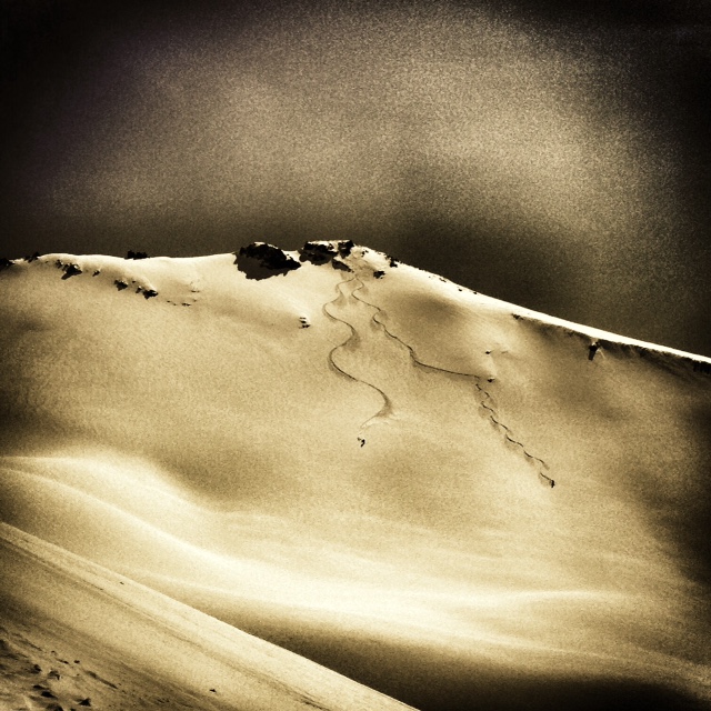
Widespread surface point release avalanches were visible for a short period when visibility cleared shortly after the storm. All of these slides were small to medium in size and did not travel very far. Snowmobilers taunted the slopes off of Sargents Ridge in the Old Ski Bowl where the point releases were occuring and had many safer users a little nervous, including myself. One report during the storm mentioned 2-3 inches of settlement or "whoomfing" on a tour near the Horse Camp cabin... he promptly turned around. While I thought we might see a decent sized wind or storm slab avalanche somewhere due to several red flags of avy danger checked off, there have been no reports or personal observations of any significant slides since the storm, only point releases and very small, insignificant and shallow surface slabs caused by ski cuts. Since the storm, temps have made a slow crescendo over the week and the snowpack has begun to settle and stabilize nicely. The storm snow has shown good bonding to the old snow surfaces and up to 13 inches of settlement.
Yesterday, folks of all user type skied and snowmobiled on slopes all over the south side of the mountain. These were slopes of all aspects around the compass rose that I would consider potentially suspect, but still there were no unstable results. Snow pit tests have shown good stability and while I think that we are past the time of the most elevated concern, I would not fully write off the possibilty of further point releases and maybe a small slab. Dig a pit, locate potential weak layers and make good judgement. It's a mixed bag out there pending on aspect and elevation: powder, heavy snow, breakable crusts, drifts, scoured areas and shallow buried objects can all be encountered.
Photos:
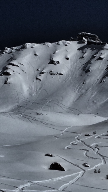
Left - Skiers dropping in off of Green Butte Ridge. Remember, safe travel techniques mean skiing ONE AT A TIME! [Photo: J Koster]
Right - The Old Ski Bowl mid-week, tracks taunting the avy debris. Also not safe travel. Recent avy debris and high-marking right next to it...?? [Photo: M Bogatay]
For folks that are interested in climbing Mt. Shasta this weekend: All routes on the mountain are currently in great shape, however with the several feet of new snow over this past week, post holing will be a problem where significant accumulation has occured. Some areas received a good bit of wind and have scoured the snowpack down to the old snow, but these areas are far and few between. Once again, post holing will be severe and climbing Mt Shasta will be difficult. If one chooses to come up onto Shasta, ski's, snowshoes or splitboard are advised! Further... wind, extreme wind chill and winter weather will be encountered this weekend and if one still chooses to make a trip up or on Mt Shasta, be prepared! As shown this past week, severe winter storms are still possible. :)
Castle Lake and Mt Eddy zones are still hosting a shallow snowpack. All areas below about 6,000 feet in the forecast area are hosting patchy, if any snow with dirt showing around trees and in sunny spots. For Castle Lake, skiing is out of the question at this point due to lack of snow.
Report your observations to the MSAC! A photo, a few words... send them in! (nimeyers@fs.fed.us or 530-926-9614)
Sand Flat Winter Trails: OPEN, however snow depths are meager and the Lower Sand Flat road is exposed dirt. We recommend heading up to Bunny Flat and touring up the road or anywhere higher in elevation!
Pilgrim Creek Snowmobile Park: CLOSED due to lack of snow
-------------------------------------------------------------------------------------------------------------------------------
Terrain: Remember most of the terrain that we like to play on is greater than 30 degrees. Avalanches are possible on anything steeper than 30 degrees. Avoid cornices, rock bands, terrain traps and runout zones of avalanche paths.
Weather: Most of our areas avalanche danger will occur 24-48 hours after a storm. We still can see persistent weak layers from time to time and we always will be sure to let you know about that! Heed the basic signs: Wind (significant snow transport and depositions), Temperature (rain/snow/rain/snow, which in turn weakens the snowpack), and Precipitation (Snow or rain add weight and stress to the current snowpack).
Snowpack: If snow accumulates, give the snowpack a chance to adjust to the new snow load before you play on or near steep slopes (greater than 30 degrees). Most direct action avalanches occur within 24-48 hours of recent snowfall. Watch for obvious signs of snowpack instability such as recent natural avalanche activity, collapsing of the snowpack (often associated with a “whumphing” sound), and shooting cracks. If you see these signs of instability, limit your recreation to lower angle slopes.
Human Factor: Don’t forget to carry and know how to use avalanche rescue gear. You should NOT be skiing or climbing potential avalanche slopes without having beacons, shovels, and probes. Only one person in a group should be exposed to potential avalanche danger at a time. Remember, climbing, skiing, and riding down the edge of slopes is safer than being in the center. Just because another person is on a slope doesn't’t mean that it is safe. Be an individual! Make your own decisions. Heed the signs of instability: rapid warming, “whumphing” noises, shooting cracks, snowing an inch an hour or more, rain, roller balls, wind loading, recent avalanche activity.
The Five Red Flags of Avalanche Danger any time of year include: 1) Recent/current avalanche activity 2) Whumpfing sounds or shooting cracks 3) Recent/current heavy snowfall 4) Strong winds transporting snow 5) Rapid warming or rain on snow.
Weather and Current Conditions
Weather Summary
In Mt Shasta City this morning at 0500, we have mostly clear skies and a current temperature of 28 F degrees with calm winds.
WEATHER STATION INFORMATION (0500hrs):
On Mt Shasta (South Side) in the last 24 hours...
Old Ski Bowl - 7,600 feet, the current temperature is 29 F. Snow on the ground totals 90 inches. Storm total over the week was about 2 feet, though has settled out to about half that today. Temperatures have ranged from 22 F to 43 F.
Gray Butte - 8,000 feet, the current temperature is 30 F. Temps have ranged from 25 F to 37 F. Winds have been variable in direction, averaging 5-9 mph with gusts to 21 mph, SW.
Castle Lake and Mt Eddy (West side of Interstate-5)...
Castle Lake - 5,600 feet, the current temperature is 32 F. Temps have ranged from 29 F to 53 F. The Castle Lake area received 6-8 inches of snow over the week and has settled down to about 4-5 inches. There is overall very little snow at Castle Lake and skiing is not possible.
Mt Eddy - 6,500 feet, the current temperature is 32 F. Temps have ranged from 22 F to 42 F. Current snow depth is 18 inches. The Mt Eddy area received 1-2 feet of new snow over the week and has settled several inches. Winds have been southerly in direction, averaging 1-2 mph with gusts to 9 mph, SE.
WEATHER SYNOPSIS: A couple quick moving, small storms will move through the area this weekend. Most of the action will be focused north of Mt Shasta, but we will see some clouds likely shrouding the mountain, a slight chance of light precip and increased wind on Saturday. In between all that, expect clear to partly cloud skies with fairly mild temps. Winds will increase to 25-35 mph at mid-mountain levels out of the west. Snow levels, if we get any, will drop to as low as 6,000 feet. Sunday should clear up and then be followed by another better looking storm for early next week... still however, that storm does not even compare to the whopper of this past week!
THIS SEASON PRECIPITATION: Since October 1st (the wet season) , we have received 32.77 inches of water, normal is 36.47 inches, putting us at 89% of normal. For the month of April, we sit at 1.34 inches of water, normal is 1.01, putting us at 132% of normal. For the year of 2015, we've received 13.25 inches water, normal is 21.26, equalling 62% of normal.
Snow Survey Results for April 2015 for the Sacramento, Shasta and Trinity Watersheds: 24% of normal, with water content at 26%, and an average depth of 20 inches. Historic average for snow is 83 inches. Last year at this time we were 28% of normal. Similar years to this year are 1936, 1977, 1988, 1994. More concerning is the McCloud area snowpack where there is no measurable snow. For the first time since 1945, the first year snow surveys were started on the McCloud river watershed, the survey courses were 0% of normal. The majority of southern Siskiyou County's current snowpack exists above 7,000 feet. Snow above this elevation actually show a favorable increase from last year. However, after the 4th year of below average snowpack and with no current snowpack in the lower elevations, the drought will have serious implications to water supplies and on the health of natural resources and wildlife.
Always check the weather before you attempt to climb Mt Shasta. Further, monitor the weather as you climb. Becoming caught on the mountain in any type of weather can compromise life and limb. Be prepared.
| 0600 temperature: | 30 |
| Max. temperature in the last 24 hours: | 43 |
| Average wind direction during the last 24 hours: | Variable |
| Average wind speed during the last 24 hours: | 5-10 mi/hr |
| Maximum wind gust in the last 24 hours: | 21 mi/hr |
| New snowfall in the last 24 hours: | 0 inches |
| Total snow depth: | 90 inches |
Two Day Mountain Weather Forecast
Produced in partnership with the Medford NWS
| For 7000 ft to 9000 ft | |||
|---|---|---|---|
|
Friday (4 a.m. to 10 p.m.) |
Friday Night (10 p.m. to 4 a.m.) |
Saturday (4 a.m. to 10 p.m.) |
|
| Weather | Increasing clouds | Mostly cloudy | 20% chance of snow showers before 11am |
| Temperature (°F) | 44 | 32 | 43 |
| Wind (mi/hr) | South/southeast 5-15 | South/southwest 5-10 | West/southwest 10-15 mph |
| Precipitation SWE / Snowfall (in) | / 0 | / 0 | / 0-.5 |
| For 9000 ft to 11000 ft | |||
| Friday | Friday Night | Saturday | |
| Weather | Increasing clouds | Mostly cloudy | 20% chance of snow showers before 11am |
| Temperature (°F) | 46 | 29 | 48 |
| Wind (mi/hr) | Southwest 10-20 | West 0 | West 25-35 mph with gusts higher |
| Precipitation SWE / Snowfall (in) | / 0 | / 0 | / 0-.5 |

