

You are here
Avalanche Advisory for 2015-12-04 07:34:27
- EXPIRED ON December 5, 2015 @ 7:34 amPublished on December 4, 2015 @ 7:34 am
- Issued by Nick Meyers - Shasta-Trinity National Forest
Bottom Line
The Mt Shasta area snowpack continues to build. LOW avalanche danger for all elevations and aspects exists today. Shallow buried objects are plentiful and one will need to take caution if venturing out for an early season adventure.


Avalanche Problem 1: Normal Caution
-
Character ?

-
Aspect/Elevation ?
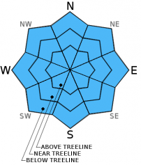
-
Likelihood ?CertainVery LikelyLikelyPossible
 Unlikely
 -
Size ?HistoricVery LargeLargeSmall

The avalanche danger is LOW for all elevations and aspects. Human triggered and natural avalanches are unlikely as new snow rests on either bare ground or a thin layer of snow from the previous storm with rocks and brush to hold things in place. Remember, LOW avalanche danger means that unstable snow can still exist on isolated features in steep terrain at higher elevations. Normal caution is advised.
Forecast Discussion
A winter weather advisory will extend to 10 am today as the current system pushes east. Precipitation will diminish by this afternoon, but skys will remain mostly cloudy through Saturday. The next storm system is set to begin moving through the area Saturday night with snow likely after midnight. Winds will increase as the storm approaches Saturday night with winds coming out of the SW at speeds up to 60 mph at 10,000 ft. The snow level will start out warm then cool as is it progresses across the region in the classic "right side up" fashion. A progressive jetstream over the Pacific will push this system along, so heavier snow with this system will occur in a relatively limited 12 hr period starting late Saturday and into early Sunday morning. This system appears to be targeted at Mt. Shasta! Potential snow amounts are uncertain at this point.
THIS SEASON PRECIPITATION: Since October 1st (the wet season), we have received 3.38 inches of water, normal is 8.03 inches, putting us at 42% of normal. For the month of December, we have received 1.35 inches of water, normal is .67 putting us at 201% of normal! For the year of 2015 we've received 20.56 inches of water, normal is 36.03 inches putting us at 57% of normal.
Recent Observations
Observations limited at this time. A shallow snowpack still prevails and riders will need to be careful. More to come!
The Five Red Flags of Avalanche Danger any time of year include: 1) Recent/current avalanche activity 2) Whumpfing sounds or shooting cracks 3) Recent/current heavy snowfall 4) Strong winds transporting snow 5) Rapid warming or rain on snow.
Weather and Current Conditions
Weather Summary
Good Morning! In Mt Shasta City at 0500, we have a current temperature of 36 F, coudy skies and intermittent, light precipitation.
MOUNTAIN WEATHER STATION INFORMATION (0500hrs):
On Mt Shasta (South Side) in the last 24 hours...
Old Ski Bowl - 7,600 feet, the current temperature is 23 degrees F. Snow on the ground totals 17.5 inches. Temperatures in the last 24 hours have ranged from 21 F to 25 F. Storm total is 13 inches.
Gray Butte - 8,000 feet, the current temperature is 21 degrees F. Temperatures have ranged from 21 F to 24 F in the last 24 hours. Winds have averaged 6 mph from the SW with a max gust to 21 mph, SW.
Castle Lake and Mt Eddy (West side of Interstate-5)...
Castle Lake - 5,600 feet, the current temperature is 26 degrees F. Temperatures have ranged from 26 F to 29 F in the last 24 hours. Snow on the ground measures 13 inches. Storm total is 11 inches.
Mt Eddy - 6,500 feet, the current temperature is 24 degrees F. Temperatures have ranged from 24 F to 29 F. Snow on the ground measures 24 inches. Storm total is 10 inches. Winds have averaged 2 mph and southerly in direction with a max gust to 5 mph, SW.
Always check the weather before you attempt to climb Mt Shasta. Further, monitor the weather as you climb. Becoming caught on the mountain in any type of weather can compromise life and limb. Be prepared.
| 0600 temperature: | 24 |
| Max. temperature in the last 24 hours: | 26 |
| Average wind direction during the last 24 hours: | Southwest |
| Average wind speed during the last 24 hours: | 6 mi/hr |
| Maximum wind gust in the last 24 hours: | 21 mi/hr |
| New snowfall in the last 24 hours: | 13 inches |
| Total snow depth: | 17.5 inches |
Two Day Mountain Weather Forecast
Produced in partnership with the Medford NWS
| For 7000 ft to 9000 ft | |||
|---|---|---|---|
|
Friday (4 a.m. to 10 p.m.) |
Friday Night (10 p.m. to 4 a.m.) |
Saturday (4 a.m. to 10 p.m.) |
|
| Weather | Snow showers, mainly before 4pm | 20% chance of snow showers before 10 pm. Mostly Cloudy | Partly sunny, breezy |
| Temperature (°F) | 26 | 25 | 35 |
| Wind (mi/hr) | Southwest 5-15 mph, gusts to 25 | South/Southwest 15-20 mph, with gusts to 25 mph | South/Southeast 20-25 mph, gusts to 35 |
| Precipitation SWE / Snowfall (in) | / 1-2 | / 0 | / 0 |
| For 9000 ft to 11000 ft | |||
| Friday | Friday Night | Saturday | |
| Weather | Snow showers, mainly before 4pm, windy with wind chill to -12 | 30% chance of snow showers before 10pm, Mostly cloudy, wind chill to -7 | Partly sunny, wind chill to -7 |
| Temperature (°F) | 12 | 14 | 27 |
| Wind (mi/hr) | West 20-30 with gusts to 40 | Southwest 2-4 | Southwest 35-45 with gusts higher |
| Precipitation SWE / Snowfall (in) | / 2-4 | / 0-.5 | / 0 |

