

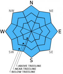
You are here
Avalanche Advisory for 2015-12-07 07:06:58
- EXPIRED ON December 8, 2015 @ 7:06 amPublished on December 7, 2015 @ 7:06 am
- Issued by Nick Meyers - Shasta-Trinity National Forest
Bottom Line
LOW avalanche danger exists for all aspects and elevations in the forecast area. Small, isolated pockets of unstable snow may exist.
Normal caution is advised. Watch out for shallow buried objects!
Climbers: A winter climb of Mt Shasta up's the ante considerably. Avalanche danger, sub-zero temperatures and extreme weather can be encountered. It is your responsibility to be prepared for all aspects of winter mountaineering.


Avalanche Problem 1: Normal Caution
-
Character ?

-
Aspect/Elevation ?
-
Likelihood ?CertainVery LikelyLikelyPossible
 Unlikely
 -
Size ?HistoricVery LargeLargeSmall

Warming temperatures over the last 24 hours have aided in consolidating the snowpack. Overall, our still shallow snowpack remains well anchored. Any instabilities are likely associated with lower density snow that could linger at the base of the snowpack below and near treeline on cold, shady aspects - NW-N-NE facing slopes.
Above treeline, snow depth totals are less due to wind, though it is not out of the realm of possibility that one could encounter small wind slab formation above treeline near ridgetops and bowls on N-NE-E slopes. Pay attention to local orographics as other aspects can be wind loaded also.
While there could be areas in the forecast area that one may find that one spot where all of the factors of weak snow, poor anchoring and sufficiently steep terrain all meld together to form a "perfect storm", play it safe and always practice safe travel techniques. Expose only one person at a time when in or below avalanche terrain, don't rely on marginal islands of safety and don't group up in avalanche runout zones!
Forecast Discussion
The forecast area will receive a titch of precipitation today. Step outside however and you'll feel the balmy morning temperature causing your winter heart to slump a little bit. Rest easy. We are going to see a brief break in storm systems and a couple days of warming this week, but Thursday should lift spirits as temps begin to cool again and another round of real winter moves in.
Today, scattered showers and an ensuing break in systems with up to a tenth of an inch of water could fall from the sky over the next 24 hours with snow levels near 8,000 feet. Winds will be mild below treeline, though above treeline one will experience breezy conditions in exposed areas, southerly in nature, 20-30 mph with gusts higher. Tuesday has a slight chance of precip, but unlikely. Wednesday, another storm approaches. Let the games begin!
THIS SEASON PRECIPITATION: Since October 1st (the wet season), we have received 4.60 inches of water, normal is 8.73 inches, putting us at 52% of normal. For the month of December, we have received 2.57 inches of water, normal is 1.37 putting us at 187% of normal. For the year of 2015 we've received 21.78 inches of water, normal is 36.73 inches putting us at 59% of normal.
Recent Observations
Albeit the small avalanche that was reported on the backside of Coyote from the Mt Shasta Ski Park yesterday, overall the snowpack has shown indications of increasing stability over the past 24-48 hours. Warming temperatures have helped to settle and increase bonding with layers in the snowpack, particularly the deeper snow layers. Any remaining concern lies in isolated areas where lower density snow remains at the base of the snowpack below and near treeline on NW-N-NE aspects. That said, that snow is pretty well anchored with our general rough ground surface: rocks, trees, brush, etc.
Above treeline, observations are limited. Salt and pepper snow surface conditions can be seen indicating a shallow snowpack. Wind as been prevalent, scouring many areas. Shallow, small to medium size wind slabs may be found in the usual areas: ridgetops, bowls and extreme terrain. Sensitivity of said slabs is unknown, so tread lightly, dig a pit, conduct a stability test!
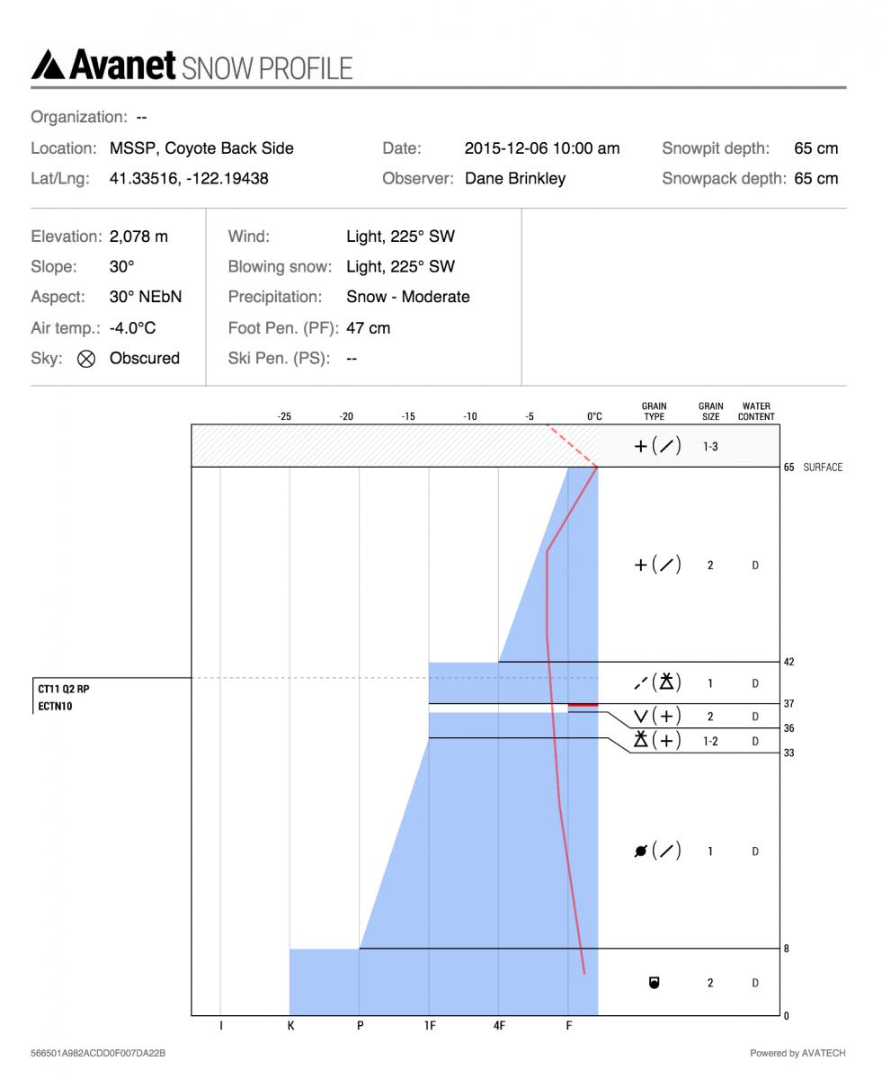
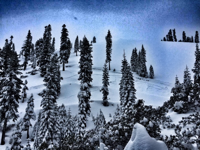
Yesterday, 12/6/15, a natural avalanche was reported from a local professional observer on the backside of Coyote, Mt Shasta Ski Park. This was a storm slab, R1-D1, 200 foot wide and 100 foot long avalanche with about an 8 inch deep crown. This slope is northeast facing at 6,000 feet and about 40 degrees. Buried surface hoar was the suspected weak layer in this isolated pocket. Photo and Pit Profile: Dane Brinkley
The Sand Flat cross country ski trails are covered and good to go! Enjoy!
Pilgrim Creek Snowmobile Park has 4-6 inches of snow at the parking area as of 12.4.15.
The Five Red Flags of Avalanche Danger any time of year include: 1) Recent/current avalanche activity 2) Whumpfing sounds or shooting cracks 3) Recent/current heavy snowfall 4) Strong winds transporting snow 5) Rapid warming or rain on snow.
Weather and Current Conditions
Weather Summary
Good Morning! In Mt Shasta City at 0500, we have a current temperature of 45 F with cloudy skies and light rain. Temperatures this morning were 12 degrees warmer than yesterday!
MOUNTAIN WEATHER STATION INFORMATION (0500hrs):
On Mt Shasta (South Side) in the last 24 hours...
Old Ski Bowl - 7,600 feet, the current temperature is 30 degrees F. Snow on the ground totals 25 inches with 1 inch new snow in the last 24 hours. Temperatures in the last 24 hours have ranged from 21 F to 30 F.
Gray Butte - 8,000 feet, the current temperature is 29 degrees F. Temperatures have ranged from 20 F to 29 F in the last 24 hours. We are having technical problems with the anemometer at this time. Working on fixing this!
Castle Lake and Mt Eddy (West side of Interstate-5)...
Castle Lake - 5,600 feet, the current temperature is 34 degrees F. Temperatures have ranged from 25 F to 34 F in the last 24 hours. Snow on the ground measures 17 inches with .5-1 inch settlement.
Mt Eddy - 6,500 feet, the current temperature is 32 degrees F. Temperatures have ranged from 23 F to 32 F. Snow on the ground measures 32 inches with 1 inch new snow in the last 24 hours. Winds have averaged 2 mph and southeast in direction with a max gust to 10 mph, SE.
Always check the weather before you attempt to climb Mt Shasta. Further, monitor the weather as you climb. Becoming caught on the mountain in any type of weather can compromise life and limb. Be prepared.
| 0600 temperature: | 32 |
| Max. temperature in the last 24 hours: | 32 |
| Average wind direction during the last 24 hours: | SSW |
| Average wind speed during the last 24 hours: | n/a mi/hr |
| Maximum wind gust in the last 24 hours: | n/a mi/hr |
| New snowfall in the last 24 hours: | .5-1 inches |
| Total snow depth: | 25 inches |
Two Day Mountain Weather Forecast
Produced in partnership with the Medford NWS
| For 7000 ft to 9000 ft | |||
|---|---|---|---|
|
Monday (4 a.m. to 10 p.m.) |
Monday Night (10 p.m. to 4 a.m.) |
Tuesday (4 a.m. to 10 p.m.) |
|
| Weather | Rain likely and cloudy | Rain likely, mainly before 10pm, cloudy | Chance of rain, cloudy. Rising temperatures. |
| Temperature (°F) | 36 | 32 | 40 |
| Wind (mi/hr) | South 5-15 mph | South 5-15 mph | South 5-15 mph |
| Precipitation SWE / Snowfall (in) | / .10 - .25 | / .10 - .25 | / 0 |
| For 9000 ft to 11000 ft | |||
| Monday | Monday Night | Tuesday | |
| Weather | Snow likely, cloudy, windy | Chance of snow, cloudy, rising temperatures, windy | Chance of snow, otherwise mostly cloudy |
| Temperature (°F) | 27 | 27 | 36 |
| Wind (mi/hr) | West 40-45 mph, increasing in the PM | West 1-2 | West/Southwest 35-40 mph then increasing to 50-55 mph in the PM |
| Precipitation SWE / Snowfall (in) | / 1-2 | / 0-1 | / 0-.5 |

